
Caribbean Sea
The Caribbean Sea is an open sea in the tropical Atlantic Ocean, located east of Central America and north of South America, covering the surface of the Caribbean plate. It is also called the sea of the Antilles because it is located to the south and west of the Antillean arc. Together with the Gulf of Mexico they form the American Mediterranean Sea.
It borders to the north with the so-called Greater Antilles —Cuba, Hispaniola (Haiti and the Dominican Republic) and Puerto Rico—, located to the south of the Tropic of Cancer, to the east with the Lesser Antilles (meridian 60° W), to the south with Venezuela, Colombia, Panama and Costa Rica (parallel 9° N), and to the west with Mexico, Belize, Guatemala, Honduras and Nicaragua (meridian 88° W), and Honduras, Nicaragua, Costa Rica (meridian 84° W).
The Caribbean Sea is one of the largest salty seas in the world and has an area of about 2,763,800 km². The deepest point of the sea is the trench of the Cayman Islands, located between Cuba and Jamaica at 7686 m below sea level. The country with the largest extension, both coastal and territorial waters, in the Caribbean is Venezuela, with 4,208 km of coastline that runs from east to west, passing through islands and archipelagos. The Caribbean coastline has many gulfs and bays: the Bay of Samaná, Las Águilas, the Gulf of Venezuela, Morrosquillo, Darién, Los Mosquitos, and Honduras.
“The Caribbean” is a region made up of the Caribbean Sea, its islands and the coasts that surround this sea.
The Caribbean Sea connects with the Pacific Ocean through the Panama Canal.
Inhabitants who were born or live in areas near this sea are called Caribbean.
History
The first inhabitants of the Antilles islands were the Taínos, a sedentary tribe with religious beliefs of a polytheistic nature and who stood out for being good farmers, fishermen and potters; their language derives from that of the Arawaks, the family from which they came, migrating from South America approximately 3,000 years ago. At the time of discovery, the Caribs, noted for their skills as navigators and warriors, predominantly occupied the region, coming from the banks of the Orinoco River, and were in full conquest of the Taino territories. In their early chronicles, the Europeans also claimed that the Caribs ate human flesh, an idea that has been recorded in the word cannibal.

The Caribbean Sea was an unknown body of water to Europe and Asia until 1492, when Christopher Columbus first sailed it trying to find a route to India. After the islands' discovery by him, the area was quickly colonized by Western civilization, becoming commonplace for European trade routes and eventually attractive to piracy. In 1495, the Catholic Monarchs allowed all their subjects to crew ships to the recently discovered Indies, which caused many vessels to launch into the Atlantic without proper preparation, being easy prey for the "wolves of the sea". On the Caribbean coast, during that time, some of the most famous commercial fairs were held, such as Portobelo, which lasted 40 days, a town where constant pirate attacks would take place, for which the Spanish built the Fort of San Lorenzo at the end of the 16th century. This same problem occurred in other Caribbean ports such as Cartagena de Indias and Havana, where military defenses were built, work for which numerous groups of African slaves were transported to the region.
Shortly after its discovery and occupation by Spain, the sea drew the attention of the English and French crowns, which sent experienced sailors to conquer territories and successfully took the islands of Martinique and Guadeloupe for France, and Antigua and Barbuda, Montserrat, Barbados and Jamaica, for England, these being the most important possessions that the Spanish Empire lost in the Caribbean.

In 1625, a base was established on the island of Tortuga where corsairs and buccaneers of both nationalities associated to attack ships from the Spanish colonies and expeditions left from there to besiege the coastal cities until the end of the 17th century. Another famous pirate base was established in the Jamaican port of Port Royal in 1656, until its partial destruction by an earthquake on June 7, 1692. In the region some names of pirates such as Morgan, El Olonés, and Blackbeard, among others.
From the 19th century the colonized countries began to become independent, although currently some French, British, Dutch, and American possessions continue under European administration. In its waters there are 22 island territories and 12 countries, Cuba being the last country to gain independence from Spain in 1898. In that same year, Puerto Rico was taken by the United States as a prize of war and remains under US rule to this day.
In 1903, with the intervention of the United States, Panama was separated from Colombia and the canal was built, connecting the Caribbean Sea with the Pacific Ocean. It was inaugurated on August 15, 1914, but was administered by the United States until December 31, 1999.
On December 12, 2001, the heads of state and government of the member countries of the Association of Caribbean States, meeting on the Island of Margarita (Venezuela), adopted the Declaration of Margarita, "recognizing the Caribbean Sea as a common heritage of the region, and an invaluable asset to which we give priority for its conservation", with the objective of "consolidating its own Caribbean identity". They have committed "to establish the Greater Caribbean region as a Zone of Cooperation", which "will initially consist of joint actions in the priority areas of the ACS, that is, Trade, Sustainable Tourism, Transport and Natural Disasters".
Etymology
The name Caribbean is derived from the Caribs, a name used to describe the predominant Amerindian ethnic group in the region at the time of first contact with Europeans at the turn of the century XV. The Italian navigator Américo Vespucci affirmed that the term Charaibi among the natives meant "wise men" and it is possible that this was used to describe the Europeans upon their arrival in the Americas. After the discovery of the West Indies by Christopher Columbus, the Spanish term Antilles was common for this place; derived from it, the "sea of the Antilles" it has been a common name for the Caribbean Sea in several European languages. During the decades following the discovery, the Spanish domain in this sea was indisputable and, therefore, the name of Antilles was maintained for many years.
Geology
The Caribbean Sea is a sea located along the Caribbean plate. It is estimated to be between 160 and 180 million years old and was formed by a horizontal fracture that divided the supercontinent called Pangea in the Mesozoic Era. The surface of the Caribbean Sea is divided into 5 oceanic basins separated by some submarine mountain ranges. The pressure exerted by the South American plate to the east of the Caribbean, makes the region of the Lesser Antilles have a high volcanic activity, highlighting events such as the volcanic eruption of Mount Pelée in 1902, which was the cause of the highest number of fatalities during the 20th century.

The Atlantic Ocean enters the Caribbean through the Anegada Passage between the Lesser Antilles and the Virgin Islands, and the Paso de los Vientos located between Cuba and Haiti, which is an important route between the United States and the Panama Canal. The Yucatan channel connects the Caribbean Sea with the Gulf of Mexico between the Yucatan peninsula in Mexico and the island of Cuba.
The deepest points are in the depression of the Cayman Islands reaching 7686 m. Despite this, the Caribbean Sea is considered a relatively shallow sea compared to other large bodies of water.
The underwater floor of the Caribbean Sea has only one oceanic trench: the Cayman Trench, since the Puerto Rico Trench, although it is close, is located on the opposite side of the island of the same name, in the open Atlantic Ocean; even so, both put the area at high risk of earthquakes. Underwater earthquakes pose the threat of generating tsunamis that could have devastating effects on the islands. Historical scientific data reveals that during the last 500 years twelve earthquakes with a magnitude greater than 7.5 on the Richter scale have occurred in the area.
Oceanography

Delimitation of the IHO
The highest international authority on sea delimitation, the International Hydrographic Organization (IHO), considers the Caribbean Sea as an independent sea. In his world reference publication, "Limits of oceans and seas" (Limits of oceans and seas, 3rd edition of 1953), he assigns it the identification number 27 and defines it as follows:
In the Yucatan channel the same limit as the one described for the Gulf of Mexico [a line that unites the Cape Catoche lighthouse (21°37'N, 87°04'W) with the lighthouse of the Cape of San Antonio in Cuba].
North. In the Winds Pass, a line that connects Caleta tip (74°15'W) and Perla tip (19°40'N) in Haiti. In the channel of the Mona, a line that unites Engaño and the end of Agujereada (18°31'N, 67°08'O), in Puerto Rico.
Eastern limits. From the tip of San Diego (Puerto Rico) to the north along the same meridian (65°39'O) to the line 100 brazas, and from there to the east and to the south, so that all islands, sand banks and shallow waters of the Lesser Antilles are included in the Caribbean Sea to the tip Galera (northeast of the island of Trinidad). From the tip Galera through Trinidad to tip Galeota (southeast extremities) and from there to tip Baja (9°32'N, 61°00'W) in Venezuela.Limits of oceans and seap. 14-15.
Oceanographic features
On average, the salinity of the Caribbean Sea is 35 to 36 parts per thousand and the surface temperature is 28 °C, while at the bottom of the sea the water reaches a temperature of 4 °C.
Caribbean currents carry considerable amounts of water from the Atlantic Ocean through the eastern passages in the Lesser Antilles to the northwest to exit the Gulf of Mexico through the Yucatán Channel. On average, between 15 and 20% of the surface water that enters the Caribbean comes from the fresh waters of the estuaries of the Orinoco and Amazon rivers, driven northwest by the Caribbean current. On the other hand, the water discharged by the Orinoco during the months of rain generates large concentrations of chlorophyll in the eastern part of the sea.
In the area between northern Venezuela, Colombia, and Nicaragua, a circular current that rotates counterclockwise occurs almost all year round. This current is generated by the heavy rainfall in the region, which can also reduce the temperature and increase the salinity and density of the water, contributing some nutrients to the water such as nitrogen, phosphorus and others used by plants.
Hydrography

The hydrographic slope of the Caribbean Sea is one of the largest in the world. The longest river that flows into it is the Magdalena, which crosses into Colombia from the Colombian Massif for about 1,540 km. The Magdalena in turn receives the flow of other rivers such as Cauca and Cesar.
Other rivers that flow into the Caribbean are: Unare, Tuy, Tocuyo, Catatumbo and Chama, in Venezuela; Ranchería, Sinú and Atrato, in Colombia; San San, Chagres (Panama Canal) and Changuinola, in Panama; Grande, Prinzapolca and Huahua, in Nicaragua; San Juan, in the southeastern area of Nicaragua, which connects Lake Cocibolca or Lake Nicaragua with the Caribbean; Coco, on the border of Honduras and Nicaragua; Patuca, Sico, Aguán and Ulúa, in Honduras; Motagua and Dulce, in Guatemala; Belize, in Belize; Hondo, in Mexico; Cauto, in Cuba; Yaque del Sur, Ozama, Nizao, Haina, Chavón and Macorís, in the Dominican Republic; Negro, in Jamaica; and Grande de Patillas, in Puerto Rico.
Estuaries that form at the mouth of rivers to the sea create special ecosystems and living conditions. The basic ecological conditions in this environment are: a salinity that fluctuates throughout the year, supply of fresh water, loaded with organic matter and nutrients, which contribute to biological productivity and also loaded with sediments that cloud the environment, and influence permanent coastal marine waters that in the Caribbean are clearer and less fertile than those of any estuary.
Also noteworthy is Lake Maracaibo, which is connected to the Caribbean through the Gulf of Venezuela, it is the largest lake in South America with an area of 13,820 km² and one of the oldest on earth.
Climate

The climate of the Caribbean is influenced by the oceanic currents of the Gulf and Humboldt. The tropical location of the sea helps to keep the water at a moderately high temperature, in a range between 21 and 32.2 °C during the year (70 and 90 °F).
The Caribbean is the source of some Western Hemisphere hurricanes. The Caribbean hurricane season occurs between the months of June to December, and with greater force between August and September. On average, about 9 tropical storms occur annually and 5 reach hurricane intensity. According to the National Hurricane Center in the Caribbean, 385 hurricanes occurred between 1494 and 1900. Air currents that develop off the west coast of Africa make their way across the Atlantic Ocean, some of which become tropical storms and they can even become Atlantic hurricanes, especially in low-pressure areas of the eastern Caribbean.
Among the historical records of the most devastating hurricanes are: Hurricane San Calixto II between October 10 and 16, 1780, which passed through the Lesser Antilles, Puerto Rico, the Dominican Republic and possibly Florida, leaving a balance of between 22,000 and 24,000 deaths, and Hurricane Mitch that originated in the Colombian Caribbean and it toured Central America to the Yucatán Peninsula and Florida between October 22 and November 5, 1998, leaving between 11,000 and 18,000 dead.
Hurricanes are an annual problem for the Caribbean islands due to their destructive nature. Coral reefs are also in danger of being destroyed by hurricanes, as they deposit large amounts of sand, mud, sediment and rocks on them.
Flora and fauna
The flora of the Caribbean Sea presents a great biodiversity: it is estimated that the Caribbean has 13,000 species of plants, and that more than 6,500 of these are endemic. Some of the plants that can be found are the olive, which is located mainly in the Dominican Republic; the caimito, which extends throughout the Caribbean region; the guayacan, the national flower of Jamaica; the ceiba, the national tree of Puerto Rico and Guatemala, and the mahogany, the national tree of the Dominican Republic.
To the south, between Panama and Colombia, the coasts of the Caribbean Sea are part of one of the most biodiverse ecosystems on the planet, the biogeographic Chocó.

The fauna of the Caribbean is characteristic of a subtropical climate, mainly influenced by warm ocean currents, 42% of its species are endemic. There are about 450 species of fish, among which we can mention the barracuda, the grouper, moray eel and various families of characins. There are also 600 species of birds, 155 of them endemic such as the cortacubas (endemic species and one of the oldest in the Caribbean); Most of the bird species are migratory, such as the mangrove canary and the green heron. According to Bidlife International in 2006 there were 29 species of birds in danger of extinction in Cuba and two officially extinct. Bird species such as the Puerto Rican amazon, the yacutinga and the sabanera dove are in danger of extinction.
There are 500 species of reptiles in the Caribbean, of which 94% are endemic such as the green iguana and the blue iguana, endemic to Grand Cayman Island (both endangered), the Mona iguana, endemic from the island of Mona (Puerto Rico), the rhinoceros iguana typical of the Dominican Republic, and the American crocodile spread throughout the islands of the Caribbean, Central America and northern South America (in danger of extinction), as well as various species of sea turtles such as the hawksbill
There are 170 endemic amphibian species in the Caribbean and according to the Global Amphibian Assessment report, in 2004 more than 80% of amphibians were threatened in the Dominican Republic, Cuba and Jamaica, and 92% in Haiti. Species such as the golden coquí are seriously threatened with extinction.
There are 90 species of mammals in the Caribbean, among the native mammals we can mention the dolphin, the manatee, the almiquí (endemic to the Antilles) and various species of bats, and the humpback whale as a migratory species. Other species such as the Caribbean monk seal they have become extinct during the last centuries due to the direct action of man. In the last 1500 years, 90% of the mammals of the Antilles have become extinct.
Ecology

9% of the planet's coral reefs are found in the Caribbean, covering nearly 20,000 square miles, many of them located off the Caribbean islands and the coast of Central America. Among them stands out the Barrier of the Belize Reef, with an area of 96,300 ha, which was declared a World Heritage Site in 1996, is part of the Great Mayan Reef (also known as Mesoamerican Reef System), which with more than a thousand kilometers in length is the second largest in the world, covering the Caribbean coasts of Mexico, Belize, Guatemala and Honduras. Currently the hot water currents are endangering the coral reefs of the Caribbean. Coral reefs support some of the most diverse habitats in the world, but they are very fragile ecosystems. When tropical waters exceed 30°C over a long period of time, the zooxanthellae die. These plants provide food for corals and give them their color. The resulting bleaching on coral reefs kills them and damages the ecosystem. Over 42% of coral colonies have completely bleached, while 95% are experiencing some form of bleaching.

The habitat maintained by the reefs is critical for some tourism activities such as fishing and diving and provides an economic income for the Caribbean nations of $3.1-4.6 billion dollars. The continuous destruction of the reefs can deteriorate the economy of the region. In 1986, the protocol of the convention for the protection and development of the marine environment in the Caribbean region came into effect, whose purpose is to protect marine life that is in danger through the prohibition of human activities that can increase its destruction in various areas. Currently, this protocol has been ratified by 15 nations. Some organizations have also been formed to preserve marine life in the Caribbean, such as the Caribbean Conservation Corporation, which seeks to study and protect sea turtles, and teach people about their care.
In relation to the above, it is worth mentioning that the Institute of Marine Sciences and Limnology of the National Autonomous University of Mexico carried out a regional study, financed by the Department of Technical Cooperation of the International Atomic Energy Agency, in in which specialists from 12 Latin American countries (Colombia, Costa Rica, Cuba, Guatemala, Haiti, Honduras, Jamaica, Mexico, Nicaragua, Panama, the Dominican Republic and Venezuela) participated, whose conclusions indicate that heavy metals such as mercury, arsenic and lead, have been identified in the coastal zone of the Caribbean Sea. The analysis of metals and toxic hydrocarbons is based on the investigation of coastal sediments that have accumulated less than 50 meters deep during the last hundred and fifty years. The results of the project were presented in Vienna, within the "Water matters" forum, and the 2011 General Conference of the aforementioned multilateral organization.
Political division


.svg)
Independent countries
Continental coasts:
Belize

- Cayo Ambergris
- Turneffe Islands
- Cayo Corker
- Cayo San Jorge
- Cayo Chapel
- Cayo Goff
Colombia

- San Andrés, Providencia and Santa Catalina
- Island of San Andrés
- Providence Island
 Sanandresan Landscape of Colombia.
 - Isla Santa Catalina
- Cayo Alburquerque
- Low New
- Cayo Bolívar
- Cayo Roncador
- Cayo Rocoso
- Cayo Santander
- Serranilla Island
- Banco Serrana
- Banco Quitasueño
- Bolívar
- Isla Tierra Bomba
- Coral Islands of the Rosary
- Córdoba
- Strong island
- Tortuguilla Island
- Magdalena
- Isla de Salamanca
- Sucre
- Archipelago de San Bernardo

Costa Rica
- Limon Province
- Calero Island
- Isla Moín
- Pacuare Island
- Palma
- Penitentiary Island
- Uvita Island
- Tortuguero Island
United States
- South Florida (State)
- Miami
- Fort Lauderdale
- Hollywood
- Pompano Beach
- West Palm Beach
- Mouthball
- Florida Keys
Guatemala

- Izabal Department
- Livingston
- Puerto Barrios
- Santo Tomas de Castilla
Honduras
- Cayos Cochinos
- Bay Islands
- Roatan
 Roatan Island, Honduras.
 - Guanaja
- Useful
- Roatan
- Swan Islands

Mexico
- State of Quintana Roo
- Cancun
- Chetumal
- Contoy Island
- Island
- Tulum
- Playa del Carmen
- Puerto Aventuras
- Cozumel
 Playa de Punta Sur, Cozumel, Mexico.
 - Holbox Island
- White Island
- Mahahual
- Punta Allen
- Akumal
- Xcalak
- Banco Chinchorro

Nicaragua
- Maize Islands
- Miskito Cays
- Pearls
Panama
- Province of Bocas del Toro
 The Caribbean Sea in Bocas del Toro, Panama.
- Isla Colón
- Cayos Zapatillas
- Isla Bastimentos
- Guna Yala Archipelago (or San Blas)
- Isla Narganá
- Naluenga Island
- Island El Porvenir
- Wichubwala Island
- Ukupseni Island
- Netherlands Cays
- Province of Veraguas
- Escudo Island of Veraguas
- Colón Province
- Grande Island

Venezuela

- Anzoátegui State
- Chinese Islands
- Border Islands
- Isletas de Píritu
- Carabobo State
- Long Island
- Falcon State
- Cayo Borracho
- Dead One
- Cayo Paiclá
- Cayo Peraza
- Cayo the fishermen
- Playuelita
- Cayo Sal
- Cayo Sombrero
- State New Sparta
- Isla de Margarita
- Island of Car
- Island of Cubagua
- State Sucre
- Caracas

- Federal Venezuelan Units
- Archipelago Los Monjes
- Archipelago Las Aves
- Archipelago The Witnesses
- Archipelago of Los Frailes
- Islands The Brothers
- Island of Aves
- Island La Sola
- Island The Turtle
- Cayo Herradura
- Tortuguillo Islands
- Island La Orchila
- Island La Blanquilla
- Island of Patos
- Archipelago Los Roques
- Gran Roque
- Cayos de Francisquí
- Long Island
- Nordisquí
- Madrisquí
- Crash
- Spenhe Fall
- Cayo Carenero
- Waterfall
- Two Mosquis
- Cayo Sal
- Big Key
- State Zulia
- San Carlos Island
- Toas Island
- Island of Zapara
- Isla Los Pájaros
- Island of Fishermen
- Providence Island
Islands of the Greater Antilles

Haiti
- Island of the Gonâve
- Turtle Island
- Isla Vaca
- Cayman Islands
Jamaican
- Cayos de Morant
- Banco de Pedro
- Cayos de Pedro
- Cayos de Puerto Real
Dominican Republic
- Saona Island
- Beata Island
- Isla Catalina
- Alto Velo Island
- Manjùria Island
Cuba
- Archipelago of the Canarreos
- Island of Youth
- Cayo Largo del Sur
 Sirenas Beach in Cayo Largo del Sur, Cuba.
- Jardines de la Reina
- Gardens of the King
- Cayo Coco
- Cayo Guillermo
- Roman Cayo
- White Key
- Cayo Sabinal
- Cayo Santa Maria
- Cayo Guajaba
- Colorado Archipelago
- Archipelago of the Canarreos

Islands of the Lesser Antilles
 Antigua and Barbuda
- Antigua
- Barbuda
- Redonda
 Barbados
 Dominica
 Grenada
- Carriacou
- Ronde Island
- Little Martinique
 San Cristóbal y Nieves
- San Cristobal
- Snow
 Saint Vincent and the Grenadines
- Baliceaux
- Bequia
- Canouan
- Mayreau
- Mustique
- Palm Island
- Small Saint Vincent
- Cayos de Tobago
- Union
- Young Island
- Saint Vincent
 Saint Lucia
 Trinidad and Tobago
- Trinidad
- Tobago
- Chacachacare
- Gaspar Grande
- Gasparillo
- Huevo Island
- Isla Monos
- Little Tobago
Territories dependent on other countries
The main islands dependent on other countries in the Caribbean are:
United States
- United States Virgin Islands
 St. Thomas, United States Virgin Islands.
- St. Thomas
- San Juan
- Santa Cruz
- Water Island, Virgin Islands (in:), Water Island

- Puerto Rico
- Culebration
- Vieques
- Mona
- Islote Monito
- Get rid of it.
- Dead Box
- Cabras Island
- Navaza
France

- Guadalupe
- Basse-Terre
- Great-Terre
- The Desirede
- Petite Terre
- Les Saintes
- Marie-Galante
- Martinique
- San Martín (France)
- Tintamarre
- Island of San Bartolomé
Netherlands
- Aruba
 Porto Marie beach in Curacao.
- Renaissance island
- Palm Island (Aruba)
- Bonaire
- Little Bonaire
- Curacao
- Little Curacao
- Pens Island
- Saba
 Palm Beach, Aruba
- Green Island
- San Eustaquio
- Sint Maarten
- Mal Aborder

.jpg)
United Kingdom


- Anguilla
- Anguillita
- Dog
- Little Scrub
- Prickly Pear
- Sandy
- Scrub
- Seal
- Hat.
- British Virgin Islands
- Cut it out.
- Virgin Gorda
- Overruled
- Jost Van Dyke
- Cayman Islands
- Cayman Brac
- Grand Cayman
- Little Cayman
- Montserrat

Economy and human activity

The Caribbean region has experienced a significant increase in human activity since its colonization period. The sea is one of the largest oil production areas in the world, with approximately 170 million tons per year. Important oil and natural gas deposits are found in the Venezuelan Caribbean, which report a production of 3,081 million barrels per day of oil (2005) and 29.7 billion cubic meters of gas (2003). The area also generates an extensive fishing industry in the countries that surround it, accounting for half a million tons of fish annually. It is a large producer of sugar cane with an annual production close to 30 million tons in 2005, which represents approximately 2% of world production.
Human activity in the area also accounts for a significant increase in pollution; estimates from the Pan American Health Organization in 1993 report that only 10% of the waste from Central America and the Caribbean islands is adequately treated.
Tourism

The Caribbean Sea is one of the meccas of international tourism. The Caribbean Tourism Organization estimates that about 12 million tourists visit the region throughout the year. The Caribbean is one of the main cruise destinations in the world. The Caribbean Tourism Organization also estimated that between 1991 and 1992, 8 million tourists who traveled on cruise ships were received. Among the places preferred by visitors and tourists, they are from the island of the Dominican Republic, Puerto Rico, Cuba, Jamaica, Aruba, Barbados, the Virgin Islands, Saint Martin, Costa Rica, the Bay Islands in Honduras, Trinidad or Margarita in Venezuela; to the cities of Cancun, Puerto Aventuras, Playa del Carmen and Cozumel, as well as the Xcaret eco-archaeological park, in the Riviera Maya; Majahual, Xcalak and Río Huache on the Costa Maya route in Mexico; o Cartagena de Indias, San Andrés y Providencia and Santa Marta in Colombia; Puerto La Cruz, Barcelona, Isla de Aves, Los Roques, Punto Fijo, Choroní, Tucacas and Barlovento in Venezuela; Bocas del Toro, Colón, Guna Yala and the Panama Canal in Panama, just to name a few of its countless destinations.
Culture

The Caribbean is the setting of inspiration for various literary works and films related to piracy and fantasy, a genre in which authors such as Daniel Defoe and Robert Louis Stevenson, among others, stand out. Among the fictional films geographically characterized in the Caribbean the Pirates of the Caribbean series of films and some of James Bond can be mentioned. An adaptation of the first series of films is represented in a Disneyland park. The life and customs of the inhabitants of the Caribbean have also been represented in literary works with authors such as the Cuban novelist Alejo Carpentier, the Dominican Juan Bosch, the Saint Lucian Derek Walcott and the Colombian Gabriel García Márquez, among others.
The Caribbean region is the cradle of various musical genres that are part of Caribbean music, such as reggae and ska, from Jamaica, merengue and bachata from the Dominican Republic; calypso from Trinidad and Tobago; reggaeton shares its origins between Panama and Puerto Rico, bolero, son cubano and son montuno originating from Cuba; cumbia, porro and vallenato from the Colombian Caribbean coast, among others.
One of the most popular sports in the Caribbean is baseball, of which there is an annual regional competition called the Caribbean Series. Cricket in the English-speaking Antilles and, more recently, soccer with all its associations affiliated to Concacaf, with the exception of Colombia and Venezuela, which are in Conmebol, also stand out. On the other hand, the regional multi-sport event that brings together the representatives of the Caribbean is the Central American and Caribbean Games, which have been held every four years since 1926, being the oldest regional multi-sport competition currently in force.
In the area of the Caribbean Sea, a great variety of languages are spoken due to the diversity of origins of their culture, among the most prominent we can mention Spanish (Mexico, Cuba, Dominican Republic, Puerto Rico and the coasts of Central and South America — including archipelagos of said countries), English (Jamaica — patois), Virgin Islands, Antigua and Barbuda, Dominica, Grenada, Saint Kitts and Nevis, Saint Vincent and the Grenadines, Saint Lucia, Trinidad and Tobago, Barbados, Cayman Islands, Anguilla, Montserrat), San Andresan Creole on the islands of San Andrés and Providencia in Colombia, French (Haiti (Creole), Guadeloupe, Martinique, Saint Martin, Saint Bartholomew), Dutch (Bonaire (Papiamento), Curaçao (Papiamento), Saba, Saint Eustatius, Saint Martin and Aruba).
The predominant religion is Catholic Christianity (Dominican Republic, Puerto Rico, Jamaica, Antigua and Barbuda, Saint Lucia, Cayman Islands, Dominica, Netherlands Antilles, Central and South American coasts), although Protestantism is practiced on some islands (Barbados), Hinduism (one of the most representative in Trinidad and Tobago), Anglicanism (Montserrat, Saint Vincent and the Grenadines), and in others Santeria (Cuba), Voodoo (Haiti) and Rastafarianism (a one of the most representative in Jamaica).

Barbados
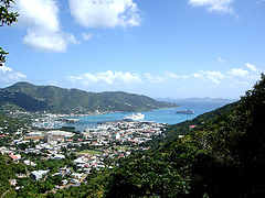
British Virgin Islands

Montserrat
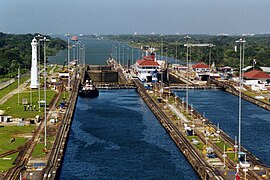
Panama Canal
Trinidad and Tobago

Rock Diamond, Martinique

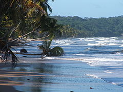
Scotts Head, Dominica


Contenido relacionado
Nile
Tabarca Island
Geography of Niger