
Cardenas (Tabasco)
Cárdenas is a Mexican city located in the state of Tabasco, head of the homonymous municipality. It is the second most populous city in the state, after the capital, Villahermosa.
Today, Cárdenas is a progressive city, a vital center for the oil, sugar, rice and chocolate industries; as well as an important communication hub inside and outside the state, since it is crossed by federal highway 180, which connects the Southeast region with the center of the country.
Etymology
The city is named after the illustrious Dr. José Eduardo de Cárdenas y Romero, on whose initiative the town was founded on the land of his ranch "Los Naranjos" donated by him. The original name of the town was San Antonio de los Naranjos, but on January 2, 1851 the name was changed to San Antonio de Cárdenas. In 1868, the H. State Congress granted the town the title of "Heroic", due to the patriotic participation of the population during the French intervention in 1863.[quote required]
History
Between 1680 and 1689, due to the incursions of English pirates under the command of Laureen Graff, alias Lorencillo, the Agualulcos had to leave Barra de Santa Ana and go inland, founding villages and towns such as San Felipe Río Nuevo (today, Villa Gutierrez Gomez) and Huimango. The Nahuatl tribe that originally inhabited the place where this population is currently located, gave it the name: “Ayahualco” which means: “In the fence full of water”.
To avoid once and for all the siege by pirates, the peoples of Chontalpa resolved in 1765 to cover the Mezcalapa or Dos Bocas river, in the so-called “don Chilo Pardo pass”, a site located in the municipality from Huimanguillo, diverting it towards a tributary branch of the Grijalva river. Since then, that channel that drastically decreased its flow, was called "Río Seco". Francisco Javier Santamaría; Historical Document of Tabasco, 1980).
Two old maps were recently found, one dated 1776, and the other dated 1777, in which a settlement called Pueblo Nuevo appears, on the site that today corresponds to the municipal seat.
Foundation of the city
On April 22, 1797, by order of the colonial governor Miguel de Castro y Araoz, and at the initiative of Dr. José Eduardo de Cárdenas y Romero, the survey of the lands of San Antonio Río Seco began, and with it, the foundation of San Antonio de Los Naranjos, in what today would be the first painting of the city of H. Cárdenas.
Manuel Gil y Sáenz in his Historia de Tabasco cites that on February 12, 1825, the town of San Antonio was granted the creation of its Town Hall in accordance with Regulatory Law No. 21 of February 9, 1825. Tabasco was governed by Don Agustín Ruiz de la Peña.

On January 2, 1851, the State Congress decreed that the town was declared a town with the name of San Antonio de Cárdenas, in memory of the most illustrious, Dr. José Eduardo de Cárdenas y Romero, by virtue of having been the donor of the land he owned "Los Naranjos", as he said: "for the widening and extension of the town."
French invasion
On June 18, 1863, Tabasco was invaded by the French, who occupied the state capital. Faced with this situation, on October 7, the illustrious Andrés Sánchez Magallanes, from Tabasco, rose up in arms in the town of San Antonio de los Naranjos, publicizing the act of insurrection calling for the "ignorance of the invading government and summoning all the towns and villages of the state to fight against the intervention", because it is "very necessary and very precise to defend the national territory, freedom and independence that the immortals Hidalgo and Morelos bequeathed to us in the proclamation and protest that they made in the year 1810.” In the minutes, the interventionist chief and self-appointed state governor, Eduardo González Arévalo, and the other authorities emanating from him were unknown; the residents of Cárdenas, as well as Huimanguillo and Otra Banda del Grijalva, were encouraged "to join us and help us shake off the chains of the oppressors". Thus, shouting Long live the Republic, die to the Colorados!!, Sánches Magallanes began the liberation struggle in Tabasco in the town of San Antonio de los Naranjos.
"Heroic" Title
In 1868, the State Congress issued a decree granting the title of "Heroic" to the town of Cárdenas as a reward for its patriotic behavior in defending the state against the French invaders and declared the colonel of National Guard of Cárdenas, Andrés Sánchez Magallanes, for having been the first to raise the national banner against the usurping power.[citation required]

At the end of 1890, the territorial division of the municipality was made up of a village (H. Cárdenas), 2 towns (Barra de Santa Ana and San Felipe Río Nuevo) and 12 rural neighborhoods (Arroyo Hondo, Bajío, Camino Nacional, Calzada, Habanero, Hidalgo, Limón and Candelero, Naranjeño, Paso and Playa, Poza Redonda and Santuario, Río Seco 1.ª, Río Seco 2.ª, Santana and Zapotal).
On September 16, 1910, by decree No. 21 of May 27, 1910, the XXIV State Legislature, at the initiative of Deputy Salvador de la Rosa and Abraham Bandala Patiño being Governor, was elevated to the category of city to the villa of H. Cárdenas.
On April 5, 1919, it was one of the 17 free municipalities into which the state is divided and on May 4, 1949, Cárdenas is ratified as a municipality of the state of Tabasco.
History Archive
Cárdenas has a historical archive, where photographs of former presidents are kept, as well as bibliographic and informative material referring to the history of the municipality, it has consultation services for the public, through prior registration.
Demographics
According to the census carried out in 2020 by the National Institute of Statistics and Geography (INEGI), in Cárdenas there were a total of 80,454 inhabitants, of whom 41,878 were women and 38,576 were men.
In 2020, a total of 31,785 homes were registered, of which 23,647 were inhabited.
Demographic evolution
During the period 2010-2020, the city had a decrease of -1.3% per year.
| Graphic of demographic evolution of Cardenas between 1900 and 2020 |
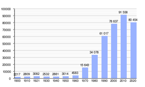 |
Source: National Institute of Statistics and Geography. |
Infrastructure

Services The city of Cárdenas, is the second most important city in the state, it has some services such as: Electric power, drinking water, public lighting, public safety and transit, cleaning service, markets, paving, drainage maintenance, pantheons, flea markets, walks and gardens. The City Council provides and manages the services of parks and gardens, markets, cleaning, sports units, tarot reading and recreation, pantheons, public safety, drinking water and municipal flea market. It has public libraries that provide various services to communities such as promoting the habit of reading within which are reading circles, story time and research time, which are activities that recreate the imagination of users.
Trade

The city has all kinds of commerce, such as supermarkets and self-service stores of national chains, cinemas, bars, hotels, meeting rooms, automotive agencies, representations of heavy machinery auto parts, car sales, grocery stores, clothing, furniture, footwear, hardware stores, construction materials, stationery and books. Among which are: Chedraui, Soriana Mercado, Bodega Aurrerá, Sam's Club, Famsa, Salinas & Rocha, Elektra, Cinemex, Coppel, OXXO; automotive agencies such as: Ford, Volkswagen, Mitsubishi, Chevrolet, Nissan; restaurants: El Costeño, Burger King, Pizza Hut, Domino's Pizza, KFC; banks such as: Banorte, Bancomer, Banamex, Scotiabank and HSBC.
Communications

The city of Cárdenas can be easily reached by road since the town is crossed by two federal highways.
- The federal highway n.o 180, also called "Circuito del Golfo y del Caribe", Coatzacoalcos-Villahermosa, which crosses the city from east to west and communicates to the city of Cárdenas, with Villahermosa, the capital of the state. It also communicates to Cárdenas with the cities of the southeast and the rest of the country.
- The federal road No. 187 Malpaso-El Bellote that crosses the city from south to north and that communicates to the Cárdenas with the cities of Huimanguillo, Comalcalco, Paraíso and the port of Dos Bocas, and which has a modern stretch of four lanes between Cárdenas and Huimanguillo.
Geography
The city of Cárdenas is located south of the municipality of Cárdenas, in the state of Tabasco; it belongs to the Grijalva region and the Chontalpa subregion; to which the municipalities of Comalcalco, Cunduacán, Huimanguillo and Paraíso also belong. It is built on the bed of the Seco River, a former tributary of the Grijalva, and has an average height of 8 m above sea level.

Climate
The climate, as in most of the state, is warm-humid, which encourages abundant vegetation to grow around the city and in sparsely urbanized areas. The city has an average annual temperature of 26.3 °C and an average annual rainfall of 2046.3 mm.
| Month | Ene. | Feb. | Mar. | Open up. | May. | Jun. | Jul. | Ago. | Sep. | Oct. | Nov. | Dec. | Annual |
|---|---|---|---|---|---|---|---|---|---|---|---|---|---|
| Temp. max. abs. (°C) | 37.0 | 39.0 | 42.0 | 43.5 | 42.0 | 42.5 | 39.0 | 39.0 | 38.5 | 38.5 | 36.5 | 38.0 | 43.5 |
| Average temperature (°C) | 27.6 | 28.9 | 31.9 | 34.3 | 35.3 | 34.3 | 33.5 | 33.5 | 32.6 | 31.0 | 29.4 | 28.0 | 31.7 |
| Average temperature (°C) | 22.9 | 23.7 | 25.9 | 28.0 | 29.0 | 28.6 | 28.0 | 28.0 | 27.5 | 26.3 | 24.7 | 23.4 | 26.3 |
| Temp. medium (°C) | 18.2 | 18.5 | 19.9 | 21.8 | 22.8 | 22.8 | 22.5 | 22.5 | 22.4 | 21.6 | 20.0 | 18.8 | 21.0 |
| Temp. min. abs. (°C) | 10.0 | 9.5 | 10.0 | 10.0 | 14.0 | 16.5 | 19.0 | 18.0 | 16.0 | 15.0 | 12.5 | 9.0 | 9.0 |
| Total precipitation (mm) | 137.5 | 90.8 | 43.0 | 51.0 | 69.7 | 217.2 | 172.3 | 232.1 | 339.0 | 344.9 | 212.7 | 136.1 | 2046.3 |
| Precipitation days (≥ 1 mm) | 10.6 | 8.1 | 5.2 | 4.2 | 4.9 | 13.3 | 14.5 | 15.8 | 17.5 | 16.4 | 11.3 | 10.7 | 132.5 |
| Source: National Meteorological Service. | |||||||||||||
Museums
Carlos Pellicer Museum that is located in the city of Cárdenas, where works of the poet, photographs and archaeological pieces of the Olmec culture are exhibited.
Works of Art
Mural: "The Heroic Cárdenas through her history", made by the muralist painter Homero Magaña Arellano, and is located in the Municipal Palace. This mural reflects the history of the city, from the colonial era, the foundation, the battles, the development of the population, etc.
Mural: "The Evolution of Man", by Ponce Montuy, at the Carlos Pellicer Cámara museum in the city.