
Cantabrian Sea
The Cantabrian Sea is the coastal sea of the Atlantic Ocean that bathes most of the northern coast of Spain and the extreme southwest of the Atlantic coast of France; it supposes the southern area of the Bay of Biscay. span>), in the province of La Coruña, to the mouth of the Adour river, near the city of Bayonne, on the coast of the Pyrenees-Atlantiques department, in the French Basque Country. It bathes 800 kilometers of shared coastline through the provinces of La Coruña and Lugo (Galicia), Asturias, Cantabria, Vizcaya and Guipúzcoa (Basque Country), and the French department of the Atlantic Pyrenees.
Etymology
The Cantabrian Sea was named by the Romans in the I century BC. C. as Cantabricus Oceanus in reference to one of the peoples that inhabited its coasts: the Cantabrians. i>Gallicus Oceanus.
Physical characteristics
The Cantabrian Sea is actually a marine trough that was formed by the collision between the Indo-European and Iberian plates between 115 and 75 million years ago. Today those plates are still in motion, in fact, Galicia and Brittany are moving apart a few centimeters a year, and the submarine canyon they form is opening up more and more. Topographically speaking, the Cantabrian continental shelf can be divided into two parts:
- The first one extends from the mouth of the Bidasoa River to Cap Vidio, and is characterized by having a North-South orientation and being extremely narrow, with a little steep slope and affected by smaller rocky blooms. Along the Cantabrian coast the platform can be reduced to less than 10 km (8 km in front of Ajo) widening west. The continental slope, a transition zone between the platform and the depth of the sea, is very pronounced with a slope of about 10-12 %, falling to 4000 m deep and is crossed by numerous cannons.
- The platform in the area that goes from Cabo Vidio to the mouth of the Miño River, is wider and uniform. The maximum width of 80 km is reached in front of La Coruña, while in front of Ortegal it is reduced to 30 km.
The seabed is divided into units by the presence of seamounts and seabeds, as well as deep submarine canyons. Among the most characteristic submarine canyons in this area are those of Capbreton, Santander, Torrelavega, Llanes, Lastres and Avilés. Some of these canyons are very pronounced, such as Capbreton, where the seabed drops 1,000 meters less than 3 km from the coast.
Geography
The Cantabrian coastline is straight and long, with a steep slope towards the sea, abundant cliffs, few beaches and small estuaries. The deposits are generally made of stone and rubble, the sediments are located within the estuaries, at the mouth of the rivers or in the inlets. The waves in the northwest sector determine the net direction of coastal transport in an easterly direction. This coastal area maintains enclaves of high ecological value and exceptional landscapes, such as cliffs, dune ridges and marshes. In this sense, El Cachucho stands out, a 235,000-hectare marine protected area located off the Asturian town of Ribadesella and at a distance of 65 km from the coast at longitude 5°W.
The grain size of the sediments decreases with depth, with medium and fine sands in the shallow waters and silts at greater depths. The finest sediments, such as silts, are located on the continental slope.
The seabed alternates between rock, gravel and mud. During the first kilometers offshore, the continental platform maintains depths between 200 and 300 m, until it reaches the continental slope where it falls to a depth of 4000 m.
Temperature
The Bay of Biscay constitutes a sea of transition between the cold seas of the north and the temperate seas of the tropics, which makes it an ecotone for cold-water plant and animal species. The outcrop of deep and cold waters existing off the Galician coast causes the water temperature to increase as we move towards the East. This surface water temperature presents a marked seasonality, so during the winter the water temperature can drop to 10 °C, while in summer it reaches approximately 22 °C. These temperatures are unusually high given the geographical region that the sea occupies. Cantabrian Sea, and are due to the warming effects of the Gulf Stream.
In winter, the agitation of the waves means that the temperature gradient as we descend is practically zero and we have to go down to 1000 m depth for the temperature to drop to 10 °C. But in summer the relative calm of the sea encourages the formation of thermoclines, the surface layer gets very hot but the heat does not reach the lower layers, producing these sudden changes in temperature. Thus, there is a permanent thermocline at a depth of about 200 m, almost coinciding with the continental shelf. From a depth of 1,000 m, the temperature is 5 °C all year round.
Salinity
The average salinity of the Cantabrian Sea is 35 g/L, although it differs slightly depending on the rainfall regime, the greater or lesser proximity to the coast and the presence of mouths of mighty rivers. Salinity also varies with depth and experiences a halocline with a significant drop at about 700 m depth.
Tides
It has a significant tidal amplitude, being able to be a maximum of 4.5 m, especially in spring tides in March. The tidal range of the northern coast of Spain differs significantly from those of the Mediterranean Sea, so the tide tables are taken into account in the Cantabrian Sea for the planning of maritime activities.
Winds
During the winter on the Cantabrian coast, the Northwest and Southwest winds predominate, the former being the one with the greatest impact on navigation due to its repercussions on sea currents and its intensity. The oceanic Northwest is the cause of the great storms of the coast, and therefore, the one that makes coastal navigation difficult in winter.
The strong winds, preferably from the Northwest, that blow over the Cantabrian Sea have their origin in the low pressures centered over the British Isles and the North Sea in combination with the Azores anticyclone. The distance traveled by the wind and the maintenance of its constant direction and speed cause waves of 2 to 3 m height to be generated, which causes quite agitated seas. Under very particular conditions, more propitious in the months of April-May and September-October, the west winds can reach gale magnitudes with waves that can exceed 7 m in height.
During spring, northerly winds blow, which in summer acquire a northeasterly component. Its low intensity and its direction facilitates navigation.
In this general scheme of winds, the one with a southern component stands out, which has to cross the Cantabrian mountain range, originating in the descent from the peaks to the coast the phenomenon known as the Foehn effect, which dries and overheats it extraordinarily. This wind, active both in winter and in summer, has a notable impact on coastal navigation and, above all, on approach and docking maneuvers in port.
The frequency of strong winds is much greater in winter and late autumn, although there are times when the dreaded gale occurs in summer, especially in July.
Currents
Generically, in areas with a predominance of west winds, such as the Cantabrian Sea, the water moves slowly in an easterly direction, which is why it has been called the west wind current. More specifically, the currents of the Bay of Biscay are characterized by being derivations of the great current of the west wind in the North Atlantic and, therefore, they tend to be irregular in intensity and direction, depending to a great extent on the prevailing winds. Thus, the most intense currents occur mainly in winter, with a clear component to the East. In the summer months, when the predominance of the west winds weakens, the surface circulation of the Cantabrian waters flows from North to South, from Brittany to the Aquitaine coast, and from East to West along the Cantabrian coast. to join with the general circulation of the South in the area of Cape Finisterre.
Biodiversity
.jpg)
As mentioned, the Cantabrian Sea forms the subtropical/boreal transition zone of the eastern Atlantic, where typical species of temperate waters from the south are found together with those of northern origin. As a consequence, there are high biodiversity indices compared to the adjacent areas. To this we must add that the topographic complexity and the wide range of substrata on its continental shelf result in many different types of habitat. It is also the spawning ground in winter and spring for some species, such as hake, megrim, sea bream, mackerel, horse mackerel and anchovy, and the feeding ground for others, such as tuna. These species along with monkfish and Norway lobster, they are the main components of the catches of the fishing fleet that fishes these waters.
The number of fish species decreases progressively with depth, with coastal waters being the ones with the highest productivity in contrast to the reverse phenomena that appear in invertebrates, which prefer deeper waters and muddy substrates due to their predominance of detrimental eating habits.
Fishing industry

Fisheries, which have operated for centuries in this sea and by extension in the Bay of Biscay, have been industrialized especially since the middle of the century XX. While in the north of Spain for the transformation and conservation of fish, pickling was especially used, in the Mediterranean salting is the one that had notable roots. At the end of the XIX century, the arrival of Italians attracted by the wealth of the Cantabrian Sea led to a de facto transformation that influenced and conditioned both the development of the manufacturing sector as well as of the extractive sector itself, and even the growth of the different coastal towns where they decide to settle. It was these Italian industrialists who introduced salting of anchovies (engraulis encrassicholus) to Spain and taught the Cantabrian population how to make the well-known anchovy fillets in oil.
Trawlers operate on the muddy bottoms of the continental shelf, while longliners work mainly on the bottom of the shelf, and gillnets are used on rocky terrain near the shoreline and shelf. There are also seasonal pelagic fisheries for anchovy (purse seine), mackerel (handline, trawl, purse seine) and tunas (troll and bait) during their spring and summer migrations.
Fisheries have had a strong impact on seabed communities and have induced changes in their structure. This impact has been mainly direct (target species fishing mortality and bycatch) and indirect through habitat modifications due to sediment erosion and benthos damage by different elements of fishing gear. Fishing discards, which in 2009 constituted more than 20% of the total catches in the Cantabrian Sea, also have an indirect impact, causing changes in biological interactions. One of the main consequences of fishing pressure on the structure of communities is that It benefits species with high growth rates and wide distribution, while the most specialized ones and those with low development rates are eliminated, resulting in a simplification of the communities. Associated with this is an increase in dominance values and a drop in biodiversity, both of which have been collected in scientific reports on fish communities in the Cantabrian Sea.
The impact of fishing in the Cantabrian Sea is comparable to that of the most intensively exploited temperate platform ecosystems in the world. Most of the commercially important continental shelf stocks in the area are or have been fully exploited or overexploited. This has been reflected in a gradual transition from long-lived, high trophic level piscivorous groundfish landings (hake, monkfish, megrim) to lower trophic level planktivorous fish (blue whiting, horse mackerel). According to scientific studies since 1993 there has been no further decline and the fisheries may have reached their historical lower trophic level limit that year.
Each year, scientific campaigns are carried out to estimate the biomass of anchovy in the Cantabrian Sea, a fishery that together with that of the white tuna (thunnus alalunga) constitutes the main source of income for the inshore fleet of most of the fishing ports of the Cantabrian coast. After the maximum historical catches in the mid-1960s, there was a sharp decline that lasted until the mid-1970s. From 1975 there was a relative increase, most probably related to the introduction of technological improvements in fishing, only to experience a sharp drop in catches from 1978 on, culminating in the historical minimums of 1982 and 1986, of around 5,000 and 8,000 tons respectively. At the beginning of the 1990s, an important recovery of the species took place, reaching total catches of 40,000 tons in 1993.
The low number of new fingerlings, caused by factors such as sea temperature, salinity or currents, together with overfishing for decades, caused the Cantabrian anchovy fishing ground to collapse in 2005, with catches that barely exceeded the 200 tons, which forced the European Commission to order a prolonged closure sine die. This fact, which scientists had been warning about for some time, turned out to be a real disaster for the fishing sector: the inshore fleet was destined to see one of its main fisheries disappear due to the uncertain recovery of the species and the powerful Cantabrian canning industry was forced to import anchovies from Argentina and the Mediterranean to supply itself. Since that fateful year the fishing sector and Cantabrian canner has been forced to adapt to sustainability criteria. Five years after the decree of the complete closure of the fishing ground, and after a costly recovery of the species, the ban was put to an end when a biomass index was found 33% higher than that of 2005.
By the year 2022, the annual scientific evaluation campaign for the anchovy estimated for that year a biomass of the adult population of about 230,000 tons, a figure well above the minimum value that guarantees the sustainability of the species (21,000 tons), which confirmed the recovery of the species and the effectiveness of the environmental sustainability management plans of the purse seine fishing sector. At the same time, since the 1990s there has been an upward trend in zooplankton and specifically copepods, which are the food for anchovies, increasing by 2.4% per decade.
Sea transport
The Bay of Biscay, and thus the Cantabrian Sea, is on the main route for supertankers that transport oil from the Middle East and Africa to European Union (EU) ports. More than 70% of the total oil consumed in the EU is transported through the Finisterre Pass directly to the English Channel and then to the final destination in different European ports. For this reason, the risk of spills has always been important and has made this region the most affected by this type of accident in the world, with major shipwrecks since 1976 and in some cases at intervals of less than a decade, such as the one in the Egeo (1992), the Erika (1999) and the Prestige (2002).
History
Human communities on the Atlantic flank of the Cantabrian Coast have historically been conditioned by the restrictions of an orography and an ecosystem that have forced them to depend on foreign spaces for food, especially cereals. The territories from which they were supplied have historically been two, each one more complicated: on the one hand, the northern plateau, to whose access the mountain range of the Cantabrian mountain range was interposed; and on the other, Atlantic Galicia and especially the interior of Aquitaine, whose access was limited by the relatively difficult sea crossing.
In this sense, the Bay of Biscay has often been considered a mare tenebrosum, closed, dangerous and difficult to navigate. However, archaeological investigations are currently challenging this view. Since the late 19th century I d. C., from its sheltered bays and inlets arose settlements that over time became of great importance, as evidenced by the emergence of the Brotherhood of the Four Villas or the Brotherhood of the Marshes, federations of ports that formed a naval and economic power of first order in the Atlantic Arc.
Sailing during the Metal Age
Since ancient times, there has been a general idea that knowledge of navigation in recent prehistoric Europe was very rudimentary compared to the great Mediterranean commercial civilizations. For this reason it was considered unlikely that the Atlantic peoples could carry out high-altitude navigation before the Iron Age. This image comes from the notion of barbarian Europe versus the civilized Orient developed by contemporary historians of the Roman conquest. However, it must be taken into account that in the Atlantic countries, land communications were complicated until the arrival of the railway, and that maritime transport was the most common way to travel.
New findings have shown experts and historians the connections of the Celtic peoples of the north of the peninsula with the European Atlantic world of the first millennium BC. C..
The works of archaeologists such as Richard Bradley or Jon Henderson lead one to think of Atlantic Europe as a series of promontories that would be in the Atlantic finisterres along the coast of the British Isles, France, Spain and Portugal connected by routes of coastal shipping that helped spread the Celtic world. Examining evidence of settlement, maritime trade, and material culture from each area, scholars point to areas of similarity fostered by maritime ties, which shaped their character and perception of themselves these communities of the Atlantic coast.
Human settlements of tribes such as Astures, Cantabrians, Autrigones, Caristios and Várdulos arose along the entire coast of the Cantabrian Sea, who made fishing their main economic activity, although in those primitive times it was not very important. It is worth noting the coastal settlements of maritime forts, more common in Asturias and Galicia, which took advantage of easily defendable sea promontories and which were configured as true watchtowers over the ocean.

Julius Caesar, Strabo and Avienus cite the use by Lusitanians, Galicians and Britons of leather boats (similar to Irish currach or Welsh coracles), which has led some authors to argue that the indigenous populations of northern the Iberian Peninsula also used them, always related to fishing, inland navigation or small coastal routes.
However, there are factors that work against the theory that Bronze Age navigators used leather boats, such as the enormous cost of covering the hull of a boat with skins, or the need to landfalls to let the leather dry and re-waterproof it (which seriously limits the distances and duration of the journeys). On the other hand, there is evidence of wooden boats for river navigation, which makes it logical to think that they were also used in maritime navigation due to their robustness and load capacity.
The common cultural sequence during the Iron Age between the castro culture of the Celtic peoples of the north of the peninsula with that of Brittany, the south of England or the north of the British Isles, in which there is a synchrony of processes (metallurgy of the iron, the appearance of the oppida, etc.), leads to the deduction of the existence of an Atlantic axis of contact and interaction. existence of commercial maritime routes at least since the Bronze Age. The presence of these and other archaeological remains prior to the Roman conquest, as well as research in the field of genetics, demonstrate the existence of maritime contacts beyond the Cantabrian coast.
On the other hand, petroglyphs such as the one at Auga dos Cebros (Oia, Pontevedra), with the representation of an Uluburun-type cargo ship from the second millennium BC, with a wooden hull, about 16 oarsmen, which has a mast in a central position and with a high prow and stern, seem to document the arrival of the first Mediterranean ships to the Atlantic arc, probably interested in the gold and tin trade.
During the pre-Roman period, the Trasmontana population reached a certain level of development and the food problem was felt. The solution consisted of making contact with the least complex and costly scenario: the Aquitanian space. In the mid-century I a. C. the interrelationship with said territory seemed to have already reached a certain consistency. Findings such as that of the Cabárceno cauldron, similar to those found near Battersea (London) or in Dublin (Ireland), or the Moñes diadem, with representations of the Irish and Welsh Celtic mythology, seem to show that maritime trade existed at least 600 years before the arrival of the Romans between the inhabitants of the northern part of the Peninsula and those of the European Atlantic zone, especially with the inhabitants of the British Isles..
The end of spring and the entire summer season would be the only suitable period for long-distance and high-altitude navigation. During the rest of the year the journeys would cover short distances, dedicated mainly to fishing, and never far from the coast. On the northwestern coast of Europe, force 7 storms are eight times more frequent in winter, and the average number of days with heavy seas is four times greater than in summer. Therefore, the most prudent thing for the navigators of the Metal Age was to make their trips in summer. It has been estimated that a framed boat could withstand force 5 storms (fresh breeze 20 knots), and a leather boat could even handle a force 6 storm (22 to 27 knots).
During this period, navigation would be non-instrumental, based on the observation of natural phenomena —such as winds, currents, and tides— or the movement of stars and planets.
Maritime trade during Roman times
.JPG)
Archaeological data indicate that the chronological evolution of the Cantabrian ports presents notable similarities. Thus, no data supports its existence during the controversial period of the Cantabrian Wars and immediately after. However, there must have been the availability of a port infrastructure capable of hosting at any given time nothing less than the landing of the Classis Aquitanica, probably at a time when land routes were formally non-existent. It would not be until the time of Tiberius, from the year 14 to 37, when the beginning of a verified commercial activity can be established.
During the period of the Julio-Claudian dynasty, enclaves such as Gijón, a Romanized indigenous settlement, and the appearance of other smaller ones along the Cantabrian coast took place. However, it will not be until the Flavian emperors when the definitive articulation of the Cantabrian ports takes place, with the takeoff or consolidation of settlements such as Flavium Brigantium, Noega, Portus Samanum-Flaviobriga, Oiasso and Portus Victoriae, strategic locations chosen well for being located sheltered from the north and northwest winds or because they are important connections with Roman roads that gave access to the interior of the Iberian Peninsula. This process would normalize the high-altitude navigation system and the integration of the Cantabrian maritime space in the domain area Roman naval.
During the II century d. C. all the mentioned ports would enjoy their maximum splendor. After the profound imperial crisis of the 3rd century, there was a recovery at the beginning of the VI century, in which an increase in in the importation of foreign products. The intense navigability of this Sinus Aquitanus is confirmed not only by classical literary sources, but above all, by archaeological evidence, as a large number of Roman remains and even wrecks on the Cantabrian coast and the Bay of Biscay, especially concentrated in the area of Fuenterrabía and Cabo Higuer. Which, along with other data such as the Cantabrian iron trade, the findings of terra sigillata Sudgalica, etc., suggest the possible existence of a maritime trade route that linked the entire Cantabrian Sea with Burdigala (now Bordeaux), and from here, a waterway along the Garona River and the Midi plain, to Narbo Martius (present-day Narbonne) with access to the sea M editerranean.
During the empire, the region of Aquitaine would be one of the great granaries of the Roman world and, without a doubt, the most capable of the Cantabrian coastal environment. other provisions from Aquitaine. The genesis and commercial development of all these Cantabrian ports would follow an expansion from east to west if we look at the chronology of the archaeological materials found in Oiasso (Irún) and Flaviobriga (Castro Urdiales), places relatively close to the important Aquitanian export port of Burdigala. Thus, all of them would be linked from the end of the Julio-Claudian period and, without a doubt, from the Flavian period, by a specifically Cantabrian maritime route, as part of a high-altitude navigation system that would connect the Mediterranean with the North Atlantic.
However, the western half of the Cantabrian region —Galicia and Asturias— was conditioned by the distance from the Aquitaine region to be able to supply itself with food, and was forced to develop a vilicario system of some importance on the coast itself which fell on agricultural production, partially supported in the interior of the Meseteño. On the contrary, the eastern half —Cantabria and Vasconia— radically dispensed with such a possibility due to its proximity to the supply granary of Aquitaine. The interrelation became established to such an extent that in imperial times the Sinus Aquitanus functioned as a true "Roman lake".
In these times, navigation in winter was still almost nil, declaring mare clausum or closed sea, which clearly reflects the paralysis of Roman maritime activity in the winter season or hiems, as opposed to the good summer season or aestas. The term mare clausum does not indicate that navigation was really prohibited, but rather that it was a practice that was not recommended between the months of November and March.
The crisis and incursions of northern peoples during the Early Middle Ages
The Roman decadence began a convulsive period with few historiographical sources. Bishop Hidacio points out in his chronicle that around the year 456 d. C. the coast was devastated by expeditions of Hérulos. During this period the Cantabrian coast was defenseless against the razzias of the peoples of northern Europe. Although the sea would probably be open to coastal navigation, there is no evidence of the existence of maritime trade or exchanges. It is unknown if the Roman ports were still active, abandoned or only served local trade.
Authors such as Sean McGrail consider that the trend in Western Europe was not the existence of ports, which did not become general until well into the historical age, but that there must have been more informal docking places, for example secluded beaches, with hardly any modifications by the hand of man.
During this period and despite the presence of pirates, the northern Cantabrian coast maintained its dependence on the Aquitaine world. In this sense, we know from Gregory of Tours that around the year 580 a Cantabrian named Mauranus undertook a pilgrimage to the sanctuary of Martin de Tours, in France, seeking healing. For this journey he embarked on one of the three ships that left for Bordeaux from an important port in Cantabria.
Until the beginning of the VII century, the historical evolution of the Cantabrian coastal region could hardly be identified with that of the interior of the peninsula, whose context and transformation followed other paths. During that long period of time, the eastern Cantabrian coast materialized its peculiar historical development, establishing a direct relationship with the Franks, although its dependence would probably be limited to pure taxation as a sign of recognition.
Subsequently, the first arrival of the Vikings to the Iberian Peninsula through the Cantabrian Sea is recorded in the year 844, the second being in the year 858. As mentioned in the Silense Chronicle, the Scandinavians tried to assault and loot numerous coastal towns, although they were defeated on numerous occasions and initially by Ramiro I of Asturias.
Commercial expansion during the Late Middle Ages

The centuries of the High Middle Ages had dismantled the economic and human fabric inherited from Antiquity, and we would have to wait for the 12th century to see a new period of prosperity in the Cantabrian societies that gave rise to urban and economic growth through fishing and commercial activity through the sea. Alternatives to trade and fishing were scarce in the central Cantabrian and eastern. The testimonies of the time speak of the surroundings of the ports in the north of the peninsula as a poor region, deficient in grain and with infertile soils, incapable of producing food in sufficient quantity for the population. Therefore, it was key to economic sustenance to risk traveling across the Atlantic to import food through maritime trade or resort to fishing to meet domestic demand and sell the surplus.
With the natural outlet to the sea through Porto closed, via the Duero River, due to the independence of Portugal in 1179, the great Castilian wool region redirected its exports through the Cantabrian ports.
The fame of the Cantabrian towns as shipyards became such that there was a need to grant them charters and privileges in everything related to the Navy, high-altitude trade and coastal shipping. These privileges and liberties granted by the monarchs through The privileges granted to the port towns, led to a rapid increase in fishing and mercantile activity, which provided sufficient naval force to collaborate significantly in the advance of the so-called Reconquista to the south, being key in the incorporation of the kingdoms of Murcia and Andalusia to Castilla. Those towns were: Santander, Laredo, Castro Urdiales, Bermeo, Guetaria, San Sebastián, Avilés, Gijón, Fuenterrabía, Santoña, Bilbao and San Vicente de la Barquera. All had their famous seamen's brotherhoods limited in each port to the internal regime, fishing operations, cargo, lookouts, mutual aid, etc.
The important naval force that appeared in the middle of the XIII century coming from the coast of the Cantabrian Sea overflowed towards the rest of the arc European Atlantic, and it did nothing but grow and establish itself, until it became a preponderant power in Atlantic waters during the following centuries. During this century La Rochelle, the main French port in the Bay of Biscay, was already frequented by ships that made the Atlantic route to England and Flanders.
The powerful confederations of Cantabrian port towns emerged at this time, such as the Brotherhood of the Four Towns or the Brotherhood of the Marshes, which formed a first-rate maritime power at the service of the Crown of Castile, maintaining autonomy in its international commercial relations. The ports of the Brotherhood constitute important centers of maritime trade or naval arsenals, being a fundamental piece of the economy of the kingdom. Slowly starting at the end of the 12th century and more rapidly since the end of the XIV, a trade route was created with great effort that linked the Cantabrian ports with those of the North Sea in a transverse direction.
In the XIV century, regular routes were opened from Cantabrian ports to the Mediterranean and North Sea ports, and He went annually to the high-altitude fisheries in France, Ireland or the Canary Islands, where the ships ventured to catch pelagic species that were advantageous from an economic point of view.
Throughout the XIV and XV the small Cantabrian gauged ports continued to assert their presence in the maritime arc that stretched from the western Mediterranean to the North Sea, forming a hegemonic-looking maritime power, capable of acting as an arbitrator between the other maritime nations during the Hundred Years War and to curb the expansionary claims of an entity as powerful as the Hanseatic League.

Throughout the Middle Ages, commercial traffic between the ports of the Celtic Sea was frequently interrupted by wars and conflicts, sometimes only between certain towns or cities, and which nurtured and increased the corsair traditions of the local seafaring populations. Castilians and French on one side and English on the other belligerent in a give and take that conditioned maritime traffic in the English Channel and the Bay of Biscay, taking numerous ships from both sides. On the Castilian side, it is worth noting the looting of Walsingham, the Isle of Wight, Dover, Rye, Portsmouth, Plymouth and the taking of Roche-Guyon in the study of the Seine. In 1380 a Castilian fleet under the command of Fernando Sánchez de Tovar went up the River Thames daring to land in Gravesend, a few kilometers from London. On the English side, the corsair Arripaye transported pilgrims to Santiago de Compostela with a license and in the tornaviaje he filled the warehouses plundering the coasts of Castile and France, going so far as to set fire to Gijón and sack Finisterre. In response in the year 1405 Pero Niño captained a fleet combined Castilian and French that completely destroyed Poole, base port of the English corsair. In his particular revenge, the English led a fleet of 15 ships through the English Channel in 1407, capturing numerous Castilian and French cargo ships.
The important squadrons necessary to sustain all this maritime activity were designed to navigate the difficult waters of the European Atlantic coast. This led to the appearance of a shipyard activity along the bays and inlets of the Cantabrian coast in which the traditional construction techniques of medieval sailing ships were refined, incorporating new technologies that allowed high-altitude journeys to be carried out and Renaissance geographic expansion to be achieved. of later centuries. All this in addition to the hand of a school of skilled sailors and pilots who emerged in the aforementioned towns and hardened in the complicated Atlantic waters.
This naval power was maintained with certain ups and downs during the XV century, laying the necessary foundations, in terms of sailors, ships and nautical knowledge, to achieve the feat of Discovery.
Fishing became a fundamental economic activity for the communities dependent on the Cantabrian Sea, especially the capture of whales, now extinct in the region. During the Late Middle Ages, the start of whaling in these waters took place. Normally the places of pollock in the Cantabrian were the ones that had rights over these fisheries, almost always reserving a part of the animal. Thus, the hunting of the right whale became widespread between the ports of the Basque Country, Cantabria, Asturias and Galicia, whose activity marked the customs and personality of many of these populations over the centuries.
The right whale moves in shallow waters near the coast, approaching bays and inlets, which favored its hunting and exploitation. In the eastern Atlantic, this species migrated in winter to waters located between the Azores and Madeira archipelagos, the Bay of Biscay and the coasts of Western Sahara. In summer they moved towards the seas located between Iceland, Svalbard and the coasts of Norway.
The first documental record of fin whale hunting in the Cantabrian Sea comes from the French Basque Country (Bayonne) and corresponds to the year 1059, followed by one from Santoña, dated 1190 and another from Motrico from 1200. In Asturias the first known document is dated 1232 and in Galicia the first mention of whaling dates back to the year 1371. Although there is archaeological evidence of the use of skeletal remains of the species of gray whale in pre-Roman times in the Campa Torres castro (Gijón) in the IV century B.C. C. or III a. C., it cannot be assured that they were actively hunted or if rather their use came from occasional strandings, so whaling on the Cantabrian coasts during the Ancient Ages has not been proven.
Mainly the peccary or blubber was obtained from the whale, intended for lighting, and the baleen, a material appreciated for its flexibility, products that, because they were not perishable, could be transported to the interior of the Iberian Peninsula at a time when, as already mentioned, the routes through the Cantabrian Mountains were complicated. The meat was hardly eaten in Spain and was exported to the French Basque Country preserved in brine.
Historians place the heyday of whaling in the Cantabrian Sea between the 13th and 14th centuries. During the early days, the different coastal towns built watchtowers from which to watch the sea and watch the blowing of the whales during the breeding season, between October and March. The hunt was carried out from pinnaces or boats of about eight components, between rowers, harpooner and helmsman. After being harpooned, the whale fled plunging into the depths of the sea, dragging the fragile boat to which it was attached by a line, in a dangerous set that had something epic. Once dead, the cetacean was towed to the port of origin of the boat, where it was washed up on the beach, proceeding to its quartering.
Over time, the whaling became ever more far-reaching, as evidenced by the importance of transatlantic fisheries to Newfoundland. Around the year 1520, Basque whalers settled in the Labrador peninsula (Canada) to hunt fin whales. Specialists of these centuries maintain that the trips and inshore fisheries through the Cantabrian Sea, together with those carried out in Ireland and England, served in a way as preparation and training for the subsequent transatlantic voyages to the coasts of Newfoundland.
The right whale was hunted in the Cantabrian Sea for at least eight centuries until its extinction. Currently it has almost disappeared from the eastern Atlantic where it can be seen only sporadically, now concentrating its troops on the North American coast.
Modern Age
Late 14th century and early <span style="font-variant:small-caps;text" century XV storms in the Atlantic were frequent and of great intensity. It coincides with the beginning of the period called the Little Ice Age and numerous testimonies of catastrophes related to storms are recorded. The sea had a hostile nature and the loss of human lives went beyond the maritime sphere, directly threatening the populations of the Cantabrian coast when storms broke out. The number of deaths at sea each year is not easy to count, the residents of San Vicente de la Barquera assured that they lost about 100 men between 1515 and 1516, especially disastrous years as far as tragedies at sea are concerned.
During the first third of the 15th century the privateering activity at sea continued, but despite these attacks the trade with Flanders was still very active in these years. The rivalry between the Hanseatic League and the crown of Castile led to frequent seizures of ships by both sides, without a prior declaration of war and by virtue of the compensation that each one estimated should receive for the acts of the contrary. This meant that commercial expeditions were not made except with strong and numerous fleets as the waters between the Cantabrian ports and the North Seas were increasingly full of pirates and corsairs. Things continued in this situation in such a way that no Hansa ship was seen on the Iberian coast. Such animosity between Hanseatics and Castilians would settle in 1444, the year in which peace was reached. By then the unification of the Spanish monarchy under the reign of Ferdinand II of Aragon and Isabella I of Castile, the establishment of consulates in other nations and above all the great discoveries of the end of the century XV, gave new directions to trade, causing the irremediable decline of the great Hanseatic League and the end of the reasons for enmity.
With the discovery of America in 1492, the active participation of the men of the Cantabrian region in the great oceanic expansion carried out by the Hispanic Monarchy, through the ships built on its shores and the men who piloted them, increased relations with communities from other latitudes. This had the virtue of leaving deep marks on the minds of the population in the areas closest to the coast, manifested in a remarkable ability to adapt and an open receptive attitude towards novelties.
The demand for ships derived from the Carrera de Indias led to an increase in the number of ships built along the Cantabrian coast from 1505, from Fuenterrabía to Santander. Over the centuries XIV, XV and XVI the ship, with a tonnage of 100 tons, was the prototype of a one-armed merchant ship (lacking oars) and with a round rig built in the Bay of Biscay. On the contrary, the caravel, from 60 to 80 tons and whose origin is located in small fishing boats on the coast of Galicia, Portugal and Atlantic Andalusia, began to be built in the Cantabrian Sea in the middle of the century XV. The merchant galleons would be the vessels with the greatest tonnage during these centuries and with the passage of time referred to those built expressly for war under the protection of the Spanish Crown.
If previously the largest ships were built on the Mediterranean coast, in the XVI century there was a displacement of these activities to the Atlantic, especially to the shipyards of Cantabria, Vizcaya and Cádiz, and later to El Ferrol, while the Mediterranean shipyards were left for smaller vessels.
On the Cantabrian coast, the abundant oaks and their iron veins led to the construction of many of the best ships of the time. Important shipyards such as those of Pasajes, Zumaya, Zorroza, Deusto, Colindres or Guarnizo took advantage of the huge reserves of nearby forests to raise these vessels. Construction work was carried out by quite a few shipwrights and caulkers, custodians of inherited knowledge from a long tradition dating back to the Middle Ages.
The Cantabrian riverside shipyards had extensive infrastructure. They had banks to keep the wood moist; sheds and warehouses to store materials; forges and workshops; staff quarters; stands, scaffolding and other wooden structures necessary for the assembly of the boats. There were also docks and tenders. Around all of them there was also an important auxiliary industry of elements and components necessary for the finishing of the ships that were manufactured in the shipyard itself. Sails, rigging, cooperage, motorboats, oars, pitch, and resin, used in caulking, were also obtained elsewhere. Even the large pine trees, essential for flying, were brought from as far away as the North Sea and the Baltic.
The large iron ore resources existing in the eastern area of the Cantabrian Coast favored the establishment, since Antiquity, of numerous forges and forges, some of which specialized over time in the manufacture of nails, anchors, weapons and other accessories. Added to this were important manufacturing facilities such as the La Cavada Royal Artillery Factory, whose blast furnaces supplied the necessary cannons to artillery all these ships.
Between the 16th and XIX hundreds of ships that the Crown and private shipowners used for war and ocean trade were built in the Cantabrian shipyards.
The Cantabrian ports played a key role in this booming Castilian commercial activity, especially from the XV century. Thanks to their ships, the sailors made it possible to connect Castile with the different European mercantile markets, transporting the necessary consumer products to satisfy a growing demand. The rise of trade resulted in the development of maritime transport in the Cantabrian ports.
This commercial success of the mid-15th century century is related to factors such as a rising economic climate; the formation of merchant associations such as the consulate of Burgos in 1494 and, later, that of Bilbao in 1511; the generalization of the new Italian business techniques; and the establishment of extensive networks of commercial companies established in the main European markets.
Wool was gradually added to the export of iron from Biscay, which gradually replaced English wool in the supply of the Flemish textile industry. Added to this important commercial link are other traffics and other destinations such as the French coast of Brittany, Nantes, the Norman ports of Rouen and Calais and the English ports. Atlantic but also those located in the North Sea and the Baltic, and whose destination was Castilla.
With the Hanseatic enemy gone, in Flanders, the main square of European commerce, people from Bilbao and Burgos dispute their mercantile differences. During the XVII century, Bilbao held the indisputable supremacy in all Cantabrian merchandise traffic, finally winning the game over the Burgos consulate, which had oriented its trade through the ports of Santander and Laredo. In practice, trade from Bilbao was controlled mainly by English and Dutch merchants.
The scant importance of the ports of Asturias compared to the rest of the Cantabrian communities is explained by the relative isolation that the layout of the relief imposed on this territory. The transport of goods arriving at the Asturian ports towards the interior presented even greater difficulties than for the other Cantabrian coastal territories, increasing the costs of transport, when it did not make them absolutely impossible during the winters that made the mountain passes impassable.
Francis I of France, in his wars against Emperor Charles I of Spain, resorted to privateers in his ambition to attack ships laden with riches from trade with the Americas. In response, the Gipuzkoan corsairs were a real scourge for the Gauls between 1553 and 1555, cutting communications with Newfoundland and seriously damaging French trade. Although the Gipuzkoan privateering was the most active in this war, the corsair movement enemies did not disappear either. Thus, for example, the Norman corsair François Le Clerc, known as Pie de Palo, made raids along the Cantabrian coast, burning Santa Cruz de La Palma and looting Cuba and Hispaniola. On his return he met the convoy of Pedro Menéndez de Avilés, also with a letter of marque in the service of Felipe II, who sank one of his ships. Not all privateering was professionalized, but many skippers, whose main activity was commercial, if they found lightly armed French merchantmen, they simply tried to capture them.
In 1635 war broke out again between Spain and France and in 1638 a squadron of 189 ships commanded by the Archbishop of Bordeaux, Henri d'Escoubleau de Sourdis, disrupted the Spanish fleet that was going to help Fuenterrabía, which It also meant the destruction of the town of Guetaria. The following year he did the same with Laredo in the battle of the Bay of Santoña, also capturing the captain and forcing the crew to set fire to the admiral of the Galician Squadron, these ships recently built in the Deusto shipyards on the way to La Coruña. that they had taken refuge from the French in the bay and were still insufficiently armed and manned. The archbishop's fleet continued to harass the Cantabrian coast, blocking the Spanish navy that had landed in the port of La Coruña.
These well-known French victories resulted in the disappearance of the Colindres shipyards, heavily damaged and which revealed their vulnerability from a military point of view, and the transfer of their work to the Guarnizo shipyard, in a bay in Santander much more protected.
Municipalities
Main municipalities on the shores of the Cantabrian Sea, from west to east:
- From La Coruña:
- Honey.
- Ortigueira.
- Kidney.
- De Lugo:
- Vice.
- Liver.
- Burela.
- Foz.
- Ribadeo.
- De Asturias:
- Castropol.
- Tapia de Casariego.
- Navia.
- Luarca.
- Chancellor.
- Muros de Nalón.
- Soto del Barco.
- Castrillón.
- Notify them.
- Luanco.
- You sing.
- Gijón.
- Villaviciosa.
- Lastres.
- Ribadesella.
- Plains.
- De Cantabria:
- Saint Vincent de la Barquera.
- Comillas.
- Bats.
- Santander.
- Camargo.
- Noja.
- Holy shit.
- Laredo.
- Castro-Urdiales.
- From Vizcaya:
- Santurce.
- Guecho.
- Plence.
- Arminza.
- Bermeo.
- Elanchove.
- Ea.
- Lequeitio.
- Ondraft.
- From Guipúzcoa:
- Motric.
- Zarauz.
- Deva.
- Zumaya.
- Guetaria.
- Orio.
- San Sebastian.
- Passages.
- Sourcerabia.
- From Atlantic Pyrenees:
- Hendaya.
- Saint John of Light.
- Biarritz.
- Bayona.
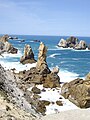
Urros de Liencres, Cantabria.
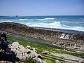
Tidal rase in Piélagos, Cantabria.
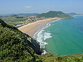
Berria Beach, Cantabria.

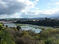
The Cantabrian coast has numerous rivers. Ría de Vivero, Galicia.
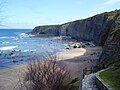
The Canary Islands coast stands out for its cliffs. Playa de Peñarrubia, Gijón (Asturias).
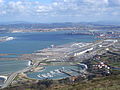
Port facilities of Bilbao, Vizcaya, Basque Country.
Saint Vincent de la Barquera, Cantabria.


Contenido relacionado
Borneo (disambiguation)
Mississippi River
Becilla