Canberra
Canberra(English pronunciation:/^kænb(§) expressed/(![]() listen), ngunnawal: Kanberra, which means "meeting place") is the capital of Australia, with a population greater than 345,000 inhabitants. It is home to the Australian Capital Territory, located in the northern part of it, 300 kilometres south-west of Sydney and 650 kilometres north-east of Melbourne. The situation in Canberra was selected for the position of the national capital in 1908 as a commitment between Sydney and Melbourne, the two major cities. It is different from other Australian cities, as it was built from scratch, as a planned city. After an international competition for the design of the city, the project was selected by the architects Walter Burley Griffin and Marion Mahony Griffin of Chicago and the construction began in 1913. The design of the city had the influence of the "garden city" movement and incorporated into different natural vegetation areas, which led Canberra to obtain the title of "capital of the bush". Although Canberra's growth and development was hampered by the two world wars and the Great Depression, since World War II it became a prosperous city.
listen), ngunnawal: Kanberra, which means "meeting place") is the capital of Australia, with a population greater than 345,000 inhabitants. It is home to the Australian Capital Territory, located in the northern part of it, 300 kilometres south-west of Sydney and 650 kilometres north-east of Melbourne. The situation in Canberra was selected for the position of the national capital in 1908 as a commitment between Sydney and Melbourne, the two major cities. It is different from other Australian cities, as it was built from scratch, as a planned city. After an international competition for the design of the city, the project was selected by the architects Walter Burley Griffin and Marion Mahony Griffin of Chicago and the construction began in 1913. The design of the city had the influence of the "garden city" movement and incorporated into different natural vegetation areas, which led Canberra to obtain the title of "capital of the bush". Although Canberra's growth and development was hampered by the two world wars and the Great Depression, since World War II it became a prosperous city.
As the seat of Australian Government, Canberra is home to the Australian Parliament and the Australian High Court, as well as numerous agencies and Ministries. There are also several social and cultural institutions of national importance. The Federal Government contributes a large percentage to the GDP and provides a wide labor offer. Canberra is a popular destination for domestic tourists, but also for foreigners.
History
Before European settlement, the area where Canberra is located was inhabited by the Ngunnawal and Walgalu tribes. The Ngarigo lived south-east Canberra, the Gundungurra to the north, the Yuin on the coast and the Wiradjuri to the west. Archaeological evidence from the Canberra region suggests a human population dating back 21,000 years. The word "Canberra" said to derive from a local Ngabri word, one of the Ngunnawal, or alternatively from the word Kambera meaning "meeting place" in the Ngunnawal language. The name Ngunnawal was apparently used to refer to the corroboree that served as protection during the seasonal migrations of the population on the Bogong moths that took place in the region each spring.
European exploration and conquest began in Canberra in the early 1820s. Four expeditions arrived between 1820 and 1824. The first white towns in the region date from 1824, when a farm or station was built where today is the Acton Peninsula, by ranchers hired by Joshua John Moore. Moore formally purchased the land in 1826, naming it Canberry.
The European population in the Canberra region continued to increase slowly through the 19th century. Among them were the Campbell family of "Duntroon"; its imposing stone house today belongs to the Royal Military College. The Campbells encouraged the establishment of Scottish farmers to work their land, such as the Southwells of "Weetangera". While the European population increased, the indigenous population was decreasing, mainly due to diseases such as smallpox or measles.
The change of the district of New South Wales (NSW) from rural area to national capital began with a series of debates around federalism in the late 19th century. Following a long dispute, whether Sydney or Melbourne should be the national capital, within a distance of no more than 100 miles from Sydney, with Melbourne being the temporary capital until the new city is completed. Canberra was chosen as the ideal site in 1908, as a result of the study carried out by the government, through the surveyor Charles Scrivener
20th century
The New South Wales government ceded land for the creation of the Australian Capital Territory. In an international design competition conducted by the Department of Foreign Affairs, on January 1, 1910, Walter Burley Griffin's design was chosen for the city, and in 1913 Griffin was selected as Director of Design and Construction for the Federal Capital, starting construction. On March 12, 1913, the city was officially named Canberra by Mrs. Denman, wife of Governor General Lord Thomas Denman, in a ceremony held on Kurrajong Hill, which from then on became known as Capital Hill and in he stands Parliament House. "Canberra Day" is a national holiday celebrated in the city and surrounding Australian Capital Territory on the third Monday in March to mark the anniversary of Canberra's founding.
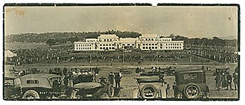
The federal government was transferred to Canberra on May 9, 1927, with the opening of the old Parliament House. The Prime Minister, Stanley Bruce, days before officially took possession of the residence at The Lodge. Planned development for the city slowed down significantly during the Great Depression in the 1930s and during World War II. Some projects planned during that time, such as the creation of cathedrals for Catholic and Anglican worship, were never completed.
Canberra's development began its recovery after the Second World War, and has since grown beyond planners' expectations. Various government departments, along with civil servants, were transferred from Melbourne to Canberra after the war was over. Housing complexes were built to accommodate the growing population. The northern and southern parts of the city had their development around the 1950s, and urban development in the Woden Valley and Belconnen districts began in the mid and late 1960s, respectively. Lake Burley Griffin was completed in 1963.
On January 27, 1972, the Aboriginal Tent was established for the first time around Parliament; it was created to draw attention to indigenous rights and land issues and has been continuously occupied since 1992. In 1973 the Lovett Tower was built, which has since been the tallest in the city.
On 9 May 1988, a larger and more permanent Parliament House was opened on Capital Hill as part of Australia's bicentenary celebration. In December 1988, the Australian Capital Territory was granted home rule after an act in the Commonwealth Parliament. The first elections followed in February 1989, where 17 members were elected to the Legislative Assembly. The Labor Party formed the first Capital Territory government, led by Prime Minister Rosemary Follett, who was the first woman to lead the Australian government.
21st century
On January 18, 2003, parts of Canberra were engulfed in a massive fire that killed four people and destroyed 491 houses, as well as destroying the main telescopes and the research workshop at the National University of Mount Stromlo Observatory. Australia.
Geography
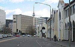
Canberra covers an area of 805.6 square kilometers and is located near the mountain range known as Brindabella, 150 kilometers inland from the east coast of Australia. The highest point in the Canberra area is Mount Majura, 888 meters high, followed by other mountains such as Mount Taylor, Ainslie, Mugga Mugga and Black Mountain, the latter site of the Telstra Tower.
Its latitude is 35° 17′00″ South, its longitude is 149° 07′41″ East and its time zone it is UT+10:00
The Molonglo River flows through Canberra and has been dammed to form the artificial lake Burley Griffin, located in the center of the city. The Molonglo is a tributary of the Murrumbidgee River, which flows north-west from Canberra towards the town of Yass, New South Wales. The Queanbeyan River joins the Molonglo only within the TAC. There are several streams, such as the Jerrabomberra and the Yarralumla, which flow into the Molonglo and Murrumbidgee. Two of the streams, specifically the Ginninderra and the Tuggeranong, have also been dammed to form their respective artificial lakes of the same name.
Climate
Canberra has a relatively dry oceanic climate, with four distinct seasons, due to its latitude, elevation, and distance from the coast. The climates of most Australian coastal cities, including state capital cities, are tempered by the sea. Canberra, however, alternates hot and dry summers with cold and cloudy winters, with occasional snowfalls.
The maximum temperature recorded in Canberra was 42.2 °C on February 1, 1968, while the minimum was −10.0 °C on July 11, 1971. January is usually the hottest month of the year, with a maximum of 27.7 °C, ten days on average with temperatures of 30 °C or more, and two days with more than 35 °C. Due to its characteristic location in the interior and its elevation, the night temperatures of the city tend to soften remarkably. The minimum temperatures in January are 13 °C. On the other hand, the coldest month in Canberra is July, with an average maximum temperature of 11.2 °C and a minimum of −0.2 °C. In total there are usually 99 days of frost, 95 of them occurring during the winter months from April to October.
The rains, meanwhile, usually occur in spring and summer, collecting an average of 629 mm of precipitation annually during 108 rainy days a year. Storms generally occur between October and March. In Canberra an average of 23 days of storms are experienced per year, reaching 19 of them during the aforementioned storm period. Snowfall is very rare in the area, and when it does occur, it barely sets.
| Month | Ene. | Feb. | Mar. | Open up. | May. | Jun. | Jul. | Ago. | Sep. | Oct. | Nov. | Dec. | Annual |
|---|---|---|---|---|---|---|---|---|---|---|---|---|---|
| Temp. max. abs. (°C) | 42.0 | 42.2 | 37.5 | 32.6 | 24.5 | 20.1 | 19.7 | 24.0 | 28.6 | 32.7 | 39.9 | 39.2 | 42.2 |
| Average temperature (°C) | 28.0 | 27.1 | 24.5 | 20.0 | 15.6 | 12.3 | 11.4 | 13.0 | 16.2 | 19.4 | 22.7 | 26.1 | 19.7 |
| Average temperature (°C) | 20.6 | 20.1 | 17.6 | 13.4 | 9.4 | 6.7 | 5.7 | 7.0 | 9.8 | 12.8 | 15.8 | 18.8 | 13.1 |
| Temp. medium (°C) | 13.2 | 13.1 | 10.7 | 6.7 | 3.2 | 1.0 | -0.1 | 1.0 | 3.3 | 6.1 | 8.8 | 11.4 | 6.5 |
| Temp. min. abs. (°C) | 1.6 | 3.0 | -1.1 | -3.7 | -7.5 | -8.5 | -10.0 | -8.5 | -6.8 | -3.4 | -1.8 | 0.3 | -10.0 |
| Total precipitation (mm) | 58.5 | 56.4 | 50.7 | 46.0 | 44.4 | 40.4 | 41.4 | 46.2 | 52.0 | 62.4 | 64.4 | 53.8 | 616.4 |
| Precipitation days (≥ 1 mm) | 7.3 | 6.7 | 6.9 | 7.3 | 8.4 | 9.8 | 10.5 | 11.1 | 10.2 | 10.4 | 9.8 | 7.8 | 106.2 |
| Hours of sun | 294.5 | 254.3 | 251.1 | 219 | 186 | 156. | 179.8 | 217 | 231 | 266.6 | 267 | 291.4 | 2813.7 |
| Source No. 1: Climate averages for Canberra Airport Comparison (1939–2010) | |||||||||||||
| Source No. 2: Special climate statements and climate summaries for more recent extremes | |||||||||||||
Urban structure
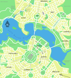
Canberra is a modern city that was designed on a plan by the American architect Walter Burley Griffin whose urban approach dates from 1912. The city is organized into neighborhoods (quarters), according to functions and characteristics. Hence, it is possible to distinguish an administrative area, a commercial and business area, an industrial and labor area, a university, residential and leisure area.
The city surrounds the artificial Burley Griffin Lake, which was built in 1963. To the south of the lake is the administrative area with the Parliament as its central point, from where concentric streets and streets converge on it. Around the Parliament are located embassies, administrative offices, museums, galleries, and parks. The Parliament is inside a large roundabout and on a hill. To the north of the lake, there are the commercial area (usually called City), residential neighborhoods and universities. The city concentrates a large number of museums, which constitute its main attraction. Most of them are free to access. Among the most prominent is the Australian War Memorial.
On the other hand, urban areas are arranged in a hierarchy of districts, squares, neighborhoods and industrial zones. There are seven districts, each one of them is divided into small suburbs and have their own squares, where most of the commercial, social and leisure activity of the districts is concentrated. These are:
- North Canberra, founded and inhabited during the 1920s and 30s, enjoying great expansion during the 60s, now contains 15 neighborhoods
- South Canberra, they lived from the 1920s to the 60s, 12 neighborhoods
- Woden Valleyinhabited for the first time in 1963, 13 neighbourhoods
- Belconnen, first in 1967, 25 neighborhoods
- Weston Creek, the first settlements were in 1969, 8 neighborhoods
- Tuggeranonginhabited since 1974, 19 neighborhoods
- Gungahlinthe last to settle, during the 1990s and has 7 neighborhoods
The North and South districts are essentially based on Griffin's designs. In 1967, the then National Capital Development Commission adopted "Plan Y", which put on the table the future urban development of Canberra, which consisted of the creation of areas for commerce and shopping known as 'town centres' (city centres), which are squares and main streets used for commercial activities, linked by motorways, arranged to form the letter Y. Canberra's urban development has been closely regulated by the government.
Most neighborhoods have their own local stores and are located near large shopping malls that serve other neighboring neighborhoods. Schools and other community facilities are often also close to these centers. Many of the neighborhoods are named after former Prime Ministers, famous Australians, early founders, or use Aboriginal names. For example, the streets of Duffy were named after Australian ladies, the streets of Page were named after biologists or naturalists. Most of the diplomatic missions take place in the neighborhoods of Yarralumla, Deakin and O'Malley. While the main industrial areas are based in Fyshwick, Mitchell and Hume.
One of the most characteristic features of Griffin's design is its peculiar triangular layout, in the heart of the center of the capital. This triangle is located and formed by Commonwealth Avenue, Kings Avenue and Lake Burley Griffin itself. This area is the most touristy since it contains many of the symbols of the city and the country such as Parliament, the aforementioned lake, the National Gallery of Australia, the High Court of Australia or the National Library of Australia (national library). This city center was designed by Griffin to house the highest public institutions in Australia, but events, commemorations, protests or parades are also held here.
During the short life of the city, Canberra has experienced several periods of highly controlled development. The first of these was during the 1920s, during the creation of the old Parliament and its gardens. The second, from 1950 to 1970, corresponded to the construction of Lake Burley Griffin and the National Library. Various types of trees were also planted to open up parks, outdoor spaces and accentuate the lake shore. In the 1980s the construction of the Supreme Court of Australia and the National Gallery of Australia took place. The last notable development was the construction of Parliament House, opened in 1988.
Demographics
As of June 2006, Canberra's population was 333,940, and the city had a density of 414.5 people per square kilometer. The 2001 census revealed that 1.2% of the Canberran population has indigenous origins and 21.6% were foreign-born. The vast majority of these come from English-speaking countries, specifically the United Kingdom and New Zealand. A significant group of immigrants come from countries such as Germany, France, Belgium, the Netherlands, Greece, Italy, Turkey and Vietnam. Recent immigrants have come to Canberra from various parts of Southeast Asia. Most Canberrans speak English as their first language, with many having other second languages such as Chinese, Italian, Croatian and Greek.
Canberra's population is relatively young, mobile and educated. The median age is 32, and only 8.3% of the total population is over 65. Between 1996 and 2001, 61.9% of the population moved to or from Canberra, which it means the second position of the Australian capital-cities whose population moves with more frequency. we take into account that the national average is around 19%. Approximately 50% of Canberrans describe themselves as Christians, the majority Catholic and Anglican, less than 3% are non-Christians and 23% are not. it is considered religious.
In 2002 the majority of crimes committed in Canberra were property offences, such as attempted and completed motor vehicle thefts. They affect 1,961 people and 630 out of 100,000, respectively. Homicides in general affect 1.5 out of every 100,000, which is below the 4.9 national average. The average number of assaults and sexual assaults is also lower than the Australian average.
Government
The Australian Capital Territory includes the city of Canberra and a few other small towns and communities. The TCA Legislative Assembly plays the role of municipal council and territorial government. The Assembly consists of 17 members, elected from three districts: Molonglo, Ginninderra and Brindabella, who elect seven, five and five members respectively. The Chief Minister is elected by the Members of the Legislative Assembly (MLA) and the MLA selects four other members of this assembly to form an Executive Cabinet. In the 2004 election, the Australian Labor Party, led by Jon Stanhope, won nine of 17 seats to form the first TCA government with an absolute majority.
Economy
As of July 2006, the unemployment rate in Canberra was 2.8%, a level that is better than the national rate of 4.8%, and with a shortage of troops in some sectors. As a result of low unemployment and a good level of public sector, Canberra has the highest average income of all Australian capitals.
The average gross salary for a Canberran is A$1,208.50, higher than the national average of $1,043.10. The average home price in Canberra as of June 2005 was $352,500, up lower than Sydney, Melbourne and Perth, but higher than the rest of the country's state capitals. Of course, prices began to rise in the city, raising the average price of housing in September 2006 to $375,000, and $411,305 as of November 2006. Weekly rent paid in Canberra is higher than rent paid in other Australian states and territories. As of September 2006, the median rental price for a 3-bedroom home was of $320 a week, which makes Canberra the Australian state capital with the most expensive rents.
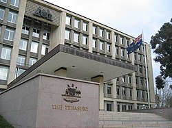
The main industry of the city is government administration and Defense, which covers 26.1% of the Gross Territorial Product in the 2003/04 academic year and employed 40% of Canberrans. The main workers in the public sector they include parliament and government departments such as the Department of Defence, Finance, Foreign Affairs and Treasury. A significant number of Australian Defense Force bases are located in or near Canberra, the most prominent being the Australian Forces offices and HMAS Harman, a naval communications centre. The former RAAF Fairbairn, an airbase adjacent to Canberra International Airport, was sold to the airport's owners, but continues to be used for armed forces VIP flights.
A recent number of software vendors are relocating to Canberra. Some of them are QSP, Tower Software, RuleBurst and The Distillery. Business services, construction, health and community services, as well as education, are the other notable contributors to Canberra's economy.
Tourism also plays an important role in the city's economy. The most famous shopping center in the city is the Westfield Shopping Center Belconnen, which has all kinds of shops and restaurants. The Manuka and Kingston districts are also home to other popular centers. The most prominent shopping areas are found in City Walk, Garema Place and in the center of Canberra.
Education and health
The two most important universities are the Australian National University (ANU), in the Acton district, and the University of Canberra (UC), in the Bruce district. The ANU was founded in 1946 as a research university and continues to carry out these tasks today, being included among the best universities in the world by the London magazine Times Higher Education and by the ranking Shanghai Jiao Tong World University. Both ANU and UC have campuses within the state and in other parts of the country such as Kioloa, New South Wales or Darwin. There are also two campuses of religious universities in Canberra: Signadou in the Watson neighborhood in the north of the city is the campus of the Australian Catholic University; and St Mark's Theological College, next to Parliament House, which is a campus of Charles Sturt University.
Canberra's military academies are the Australian Defense Force Academy (ADFA) and the Royal Military College, and are located to the north-east of the city, in the Campbell neighbourhood. The Canberra Institute of Technology is also one of the outstanding centers.
There are two large public hospitals in Canberra. The Canberra Hospital, formerly known as Woden Valley Hospital, located in Garran and with a capacity of 500 beds; and Calvary Public Hospital, located in the Bruce neighborhood and with 174 beds. Both hospitals are also teaching centers, working closely with the University of Canberra School of Nursing and the John Curtin School of Medical Research, one of Australia's leading biomedical research centres. The largest private hospital in Canberra is the John James Memorial Hospital in Deakin. The Royal Canberra Hospital was a former hospital located on the Acton Peninsula, next to Lake Burley Griffin, but it was demolished in 1997 after much controversy over the creation of the National Museum of Australia.
Culture
Canberra has a wide cultural offer that includes cinemas, theaters, museums, art galleries, sports and outdoor activities, shopping, parks and natural areas.
Attractions
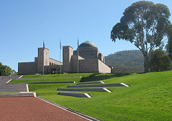
In Canberra you can enjoy a series of places that are symbols of the city itself and of Australia. Some of the most important institutions and monuments in Canberra are the Australian War Memorial, a tribute paid by the city to those who have fallen in combat during the wars in which Australian forces have participated. The memorial is reached via ANZAC Parade, a wide street that is often witness to military parades and which owes its name to the Australian and New Zealand forces (Aaustralian and N ew Zealand Army Corps) of World War I. The National Gallery of Australia houses a wealth of documents and historical material from Aboriginal, Australian and Asian cultures. Among its international artistic offer, works by Pollock and Rubens stand out. The Old Parliament House is one of the most visited places, as are the National Library of Australia, the National Archives of Australia and the National Museum of Australia. The National Library is one of the cultural symbols of Canberra and has 220 kilometers of shelves, while the National Museum was listed in 2005 as one of the national attractions.
There are a large number of Commonwealth government buildings open to the public. The most important is undoubtedly Parliament House, followed by the Supreme Court of Australia and the Royal Australian Mint. Lake Burley Griffin is another of the highlights of the Aussie capital, and is the site of the Captain Cook Memorial and the National Carillon. Other sites of great interest are the Telstra Tower, the Australian National Botanic Gardens, which have the largest collection of Australian flora in the world, the National Zoo & Aquarium or the spectacular National Dinosaur Museum, where you can even touch remains of the mythical Tyrannosaurus rex.
Music and theater also have their place in Canberra. The Canberra Theater and Playhouse hosts most of the major music festivals, concerts and other productions. Another important music-related building is Llewellyn Hall (located within the ANU School of Music). The Street Theatre, located on Childers Street, is the venue for professional and amateur theater companies. The Albert Hall was the first venue for artistic performances, opened in 1928. It was, in fact, the first performance by companies such as the Canberra Repertory Society and the Canberra Philharmonic Society.
Stonefest, held at the University of Canberra, is the city's biggest music festival and hails from Canberra the hip-hop duo Koolism. There are plenty of bars and clubs offering live music and performances, especially in the Dickson, Kingston and Downtown areas. Among the most important events and festivals in the city are the National Folk Festival, the Royal Canberra Show (a long-standing agricultural fair), the Summernats car festival, the Canberra Multicultural Festival in February and the Celebrate Canberra festival that runs for ten years. days of March next to Canberra Day, the day of the city. But the most anticipated festival for Canberrans is the Floriade, a month-long festival (between September and October) in which the entire city is decked out in flowers. This festivity also includes all kinds of shows such as music, leisure activities, seminars or landscape design contests. It has been celebrated since 1998, the year in which the 75th anniversary of the founding of Canberra and the bicentennial of Australia were celebrated, and since the success of that event it was decided to celebrate it annually.
Sports
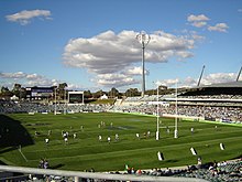
Canberra Stadium (Canberra Stadium in English) is a multi-purpose stadium located in the Bruce district, the stadium is located adjacent to the Australian Institute of Sport, the stadium seats approximately 25,000 spectators, is the main stadium of the city replacing in 1977 the Manuka Oval built in 1929. The main sports teams that have their premises in the city are the Canberra Raiders, a historic team of the National Rugby League, and the ACT Brumbies, a Super Rugby franchise.
Transportation
Canberra International Airport is the city's airport and is located 8 kilometers to the northwest. The flights are generally domestic to Sydney, Melbourne, Brisbane, Adelaide and Perth, it has a terminal and the volume of annual passengers is 2.5 million. International flights are scarce and are not direct, therefore it must be done scale.
The bus service is provided by the company ACTION (Australian Capital Territory Internal Omnibus Network), which connects the most important points of the city. The public bus network has four modern interchanges located in different districts of Canberra through which the seven lines of the "Intertown" (the intercity bus) and the thirteen of the "Xpresso", the bus that connects the city with the Parliament Triangle. Other bus companies, albeit private, are Transborder Express and Deane's Buslines, which operate within Canberra and neighboring areas of New South Wales. Aerial Consolidated Transport is a taxi and car rental company in Canberra. The CanberraCabs, a subsidiary of Aerial, is the taxi company that has served the city and has done so since 1959. A survey of transport in Canberra revealed that only 4.6% of the population use the bus, while 5.5% walk or cycle to work, a higher proportion than in any other Australian capital.
Countrylink is the rail system linking Canberra to Sydney. The journey to Melbourne begins in the town of Yass, New South Wales, but a CountryLink bus service covers the journey in around an hour. The option of implementing a high-speed rail system between Melbourne, Canberra and Sydney was considered, but it was not finally implemented as it was not considered economically viable by then Transport Minister John Anderson in 2000.
The most widely used transport in Canberra is by car as the network of roads and highways are of high quality due to the modern design of the urban layout. Canberra's districts are linked by 'parkways', wide two-lane roads limited to 80-100km/h, such as the Tuggeranong Parkway, which links Canberra's CBD to Tuggeranong and the < Weston Creek bypass. Regarding the road network that connects Canberra with the rest of the Australian cities, the National Highway (Federal Highway) connects the capital with Sydney in a three-hour journey. Melbourne is seven hours away via the Barton Freeway, which joins the Hume Freeway in Yass, New South Wales. Kosciuszko National Park and the Snowy Mountains are located two hours away via the Monaro Highway, while Batemans Bay, a popular holiday destination is also two hours away via the Kings Highway.
Sister Cities
| Cities with Canberra Twinning Agreement |
|---|
Contenido relacionado
Rotterdam
Resistance (city)
Big Houses (Mexico)
Doctors Colony
San Juan Chamula


