
Canary Islands
Canary Islands is an archipelago located in the Atlantic Ocean that makes up a Spanish autonomous community in northwest Africa, with historical nationality status. It is also one of the outermost regions of the European Union.
The Canary Islands encompass eight islands, five islets, eight rocks and the sea. Politically, the archipelago is made up of seven islands with their own administration and one island —La Graciosa— which is in the process of being managed as a district. The seven islands with their own administration are, on the one hand, El Hierro, La Gomera, La Palma and Tenerife, which make up the province of Santa Cruz de Tenerife, and, on the other hand, Fuerteventura, Gran Canaria and Lanzarote, which make up the province of Las Palmas. To these seven islands are added, on the one hand, the islets uninhabited areas of Montaña Clara, Alegranza, Roque del Este and Roque del Oeste, which, together with the island of La Graciosa, form the Chinijo archipelago, and, on the other hand, the islet of Lobos, all belonging to the province of Las Palmas In addition, to the eight islands and five islets a series of adjacent rocks are added: those of Salmor, Fasnia, Bonanza, Garachico and Anaga located in the province of Santa Cruz de Tenerife and those of Gando and Farallón de Sardina located in Gran Canaria. Finally, this autonomous community is completed with the Canarian waters, which are a special maritime area of the autonomous community and are integrated within the perimeter contour that arises from the union of the most salient extreme points of the islands and islets, being the the only autonomous community in Spain that includes the sea as part of its surface.
The archipelago is located in northwest Africa, near the coasts of southern Morocco and northern Western Sahara, between the coordinates 27º 37' and 29º 25' north latitude and 13º 20' and 18º 10' west longitude. The island of Fuerteventura is about 95 km from the coast of continental Africa. The distance to the European continental mass is about 940 km —from the islet of Alegranza to the tip of Sagres (Portugal)—. Due to its geographical location, the archipelago is the southernmost and westernmost region of the Kingdom of Spain. Historically, it has been considered a bridge between three continents; Africa, America and Europe.
The islands, of volcanic origin, sit on the African plate and are part of the natural region of Macaronesia, of which they are the largest and most populous archipelago. Its climate is subtropical, although it varies locally depending on altitude and the north or south slope. This climatic variability gives rise to a great biological diversity that, together with the landscape and geological richness, justifies the existence in the Canary Islands of four national parks and that all the islands have Unesco biosphere reserves, and others have areas declared Heritage of Humanity. These natural attractions, the good weather and the beaches make the islands an important tourist destination, being visited in 2019 by more than 13 million people. In fact, it is the leading European (and therefore Spanish) tourist power with 94 million overnight stays per year.
The Canary Islands currently has a population of 2,237,309 inhabitants and a density of 283.08 inhab./km², being the eighth autonomous community in terms of population. The population of the archipelago is concentrated mainly in the two capital islands, around 43% on the island of Tenerife and 40% on the island of Gran Canaria. The total area of the archipelago is approximately 36,567 km², and is made up of the land surface, 7,447 km², and the maritime surface of the Canary Islands waters, 29,120 km². The Canary Islands use during the boreal winter Greenwich time (UTC±0) and during the boreal summer one more (UTC+1), with an hour difference with respect to the rest of Spain.
As established in the Statute of Autonomy, the capital status of the autonomous community is shared between the cities of Santa Cruz de Tenerife and Las Palmas de Gran Canaria; the seat of the president of the autonomous government alternates between both for legislative periods, being the headquarters of the vice president different from that of the president. The Parliament is in Santa Cruz de Tenerife, while the headquarters of the Government Delegation is located in Las Palmas de Gran Canaria, there is also a Government Sub-delegation in each one of the two cities. Likewise, there is a balance between the two capitals in terms of council offices and public institutions, although the rest of the regional administration is almost entirely duplicated between both cities. For its part, in the city of San Cristóbal de La Laguna is the headquarters of the Consultative Council of the Canary Islands, which is the supreme advisory body.
Toponymy
The first written document with a direct reference to the Canary Islands is due to Pliny the Elder, who cites the trip of King Juba II of Mauritania to the islands in 40 BC. C. and refers to them for the first time as the Fortunate Islands (Fortunatae Insulae). The term Canaria also appears for the first time in this document, used to refer to the island of Gran Canaria.
According to Pliny, this name was given to the island in memory of two great mastiffs that Juba's envoys captured there and later took to Mauritania (former northwestern region of the Maghreb, not to be confused with present-day Mauritania), and that are represented on both sides of the current coat of arms of the Canary Islands.
Since Antiquity, the place name was used in the plural to refer to the whole of the archipelago. Thus, in the 4th century Arnobio de Sicca wrote about the Canary islands.
Some modern theories relate the term Canarias to the North African ethnonym canarii, a Berber group that was located in northwestern Africa. In fact, Pliny himself mentions the canarii in another text, although he again relates this term to dogs.
Historian José Juan Jiménez, from the Museum of Nature and Man in Tenerife, maintains that: «The Canary Islands owe their name to the cannis marinus, a species of large monk seal that inhabited the coasts of the Archipelago until the fifteenth century".
Symbols
.svg)

Flag
The flag of the Canary Islands has been official in this autonomous community since 1982 by Organic Law 10/1982 of August 10 on the Statute of Autonomy of the Canary Islands. This establishes, in article 7, the following:
«The flag of the Canary Islands is made up of three equal stripes in vertical sense, whose colors are from the top, white, blue and yellow»
Traditionally it is assumed that the colors of the flag derive from the colors of the two current flags of the maritime provinces of the Canary Islands; that of Tenerife (white and blue) and that of Gran Canaria (blue and yellow), being the order of the colors according to the geographical disposition of both, that is, white on the left, which corresponds to the west and Tenerife, the yellow one on the right that identifies with the east and with Gran Canaria. Blue (which both share) is located in the center.
In the Official Gazette of the Canary Islands no. 237, of December 2, 2005, the updating of the Manual of Graphic Corporate Identity of the Government of the Canary Islands was approved. In this manual, in Chapter I, the proportions of the width of the flag and the type of official yellow and blue of its colors are specified. Two versions of the Canary Islands flag are also included in this manual as the identity of the Autonomous Community: the version without the shield, which corresponds to the description given in the Statute of Autonomy, and the version that includes the Shield of the Canary Islands in the center of the flag.
Shield


The official coat of arms of the autonomous community of the Canary Islands was created in 1982 thanks to organic law 10/1982 of August 10 on the Statute of Autonomy of the Canary Islands. This establishes, in article 7, the following:
The Canary Islands has its own shield, whose description is as follows: in azur field it brings seven well-ordered silver islands, two, two, two and one, the latter at the tip. As a bell a closed royal crown, surmounted from a silver ribbon with the motto Ocean of sable and as two canes supports in its color.
In the Manual of Graphic Corporate Identity of the Government of the Canary Islands, the proportions of the shield are specified. Likewise, this manual establishes when the shield should be used, where it says exactly:
The use of the Community's shield will be limited exclusively:
- To the representation of it as a whole, for those cases of special relevance. For example: Main event of the Day of the Canary Islands, maximum distinctions, meetings of Heads of State, etc.).
- The Official Gazette of the Canary Islands (BOC) and the General Corps of the Canary Islands Police.
Natural symbols
In 1991 the Government of the Canary Islands decided that the canary bird (Serinus canaria) and the Canary Island palm tree (Phoenix canariensis) were the natural symbols of the Canary Islands.
Geography
Relief

The Canary Islands is a very recent volcanic archipelago geologically, barely 30 million years old. Its large volcanic edifices rest on large blocks of oceanic crust, and in the area of contact with the African continental crust. The arrangement of the islands reflects the network of faults present in the oceanic crust.
The geological history of the islands is very complex. We find several phases of lava flows that give a typical volcanic relief. During the great glaciations, the Canary Islands had a more arid climate that favored erosion and the appearance of debris on the slopes and ravines.
The coasts are the most exposed to the impetus of erosion, due to marine activity. There are very few accumulation zones, which means the existence of very few natural beaches. Large cliffs predominate. It is noteworthy that the Canary Islands is the Spanish region with the longest coastline: 1,583 km.
Ravines are very characteristic of the Canary Islands: they are the sporadic channel through which the current waters present in the islands are directed. Their travel is short, and they generally have a very marked rectilinear profile. Its channel is covered with debris carried by the waters.
The following table shows the highest mountains of each of the islands;
| Pico | Altitude and island |
|---|---|
| Teide | 3715 meters (Tenerife) |
| Roque de los Muchachos | 2426 meters (La Palma) |
| Agujerada morro | 1956 meters (Gran Canaria) |
| Pico de Malpaso | 1500 meters (El Hierro) |
| Alto de Garajonay | 1487 meters (La Gomera) |
| Pico de la Zarza | 812 meters (Fuerteventura) |
| Peñas del Chache | 670 meters (Lanzarote) |
| Caldera de Alegranza | 289 m (Alegranza) |
| The Needs | 266 m (La Graciosa) |
| La Mariana | 256 m (Montaña Clara) |
| The Caldera or La Herradura | 127 m (Lobos) |
Climate

The climate is subtropical oceanic, with temperatures mitigated all year round by the sea and in summer by the trade winds. We find very important variations in terms of rainfall regime. In some areas of the island of La Palma, for example, annual rainfall exceeds 1,200 mm. In the eastern islands the rainfall is less than in the western ones; thus Fuerteventura and Lanzarote are characterized by an arid semi-desert climate. The lack of rain has led to the installation of desalination plants to supply urban areas, such as Las Palmas de Gran Canaria or Santa Cruz de Tenerife. In fact, the first desalination plant in Spain was installed on the island of Lanzarote in 1964, and currently this island and Fuerteventura are supplied entirely with desalinated seawater. The porosity of the land, given its volcanic nature, makes it difficult to use of rainwater in dams and reservoirs, although these are of some importance in Gran Canaria and La Gomera. In the western islands, exploitation of underground aquifers is carried out through galleries, with the exception of the island of El Hierro, where wells and cisterns are more important. A characteristic of some places on the islands is the presence of mountains near the coast that cause the air masses to condense, giving rise to the phenomenon known as sea of clouds, and therefore, the benefit of the vegetation in the area due to humidity. However, due to the existing microclimates on the same island, we can find areas where humid forests appear and other areas where aridity is the main characteristic.
The winds tend to blow more frequently from the northeast, winds that, although they do not usually leave precipitation, do bring humidity to the areas facing that place, forming the aforementioned sea of clouds in middle and high areas. The winds from the east, sirocco, are usually accompanied by calima, that is, dust in suspension from the Sahara desert, sometimes reaching a great density.
The islands lack rivers, although the ravines are numerous and the waters run rapidly from the highlands to the coasts. Despite this, there are some continuous streams of water in La Palma, La Gomera, Tenerife and Gran Canaria.
Islands
Ordered from west to east, the Canary Islands are El Hierro, La Palma, La Gomera, Tenerife, Gran Canaria, Fuerteventura, Lanzarote and La Graciosa, the first seven having their own administration and the last being attached to the island of Lanzarote administratively. In addition, to the north of Lanzarote are the islets of Montaña Clara, Alegranza, Roque del Este and Roque del Oeste, these belonging, together with the island of La Graciosa, to the Chinijo archipelago, and to the northeast of Fuerteventura is the islet of Lobos. There are also a series of small adjacent rocks in the Canary Islands: the rocks of Anaga, Garachico and Fasnia in Tenerife, and those of Salmor and Bonanza in El Hierro. The total sum of the surface of all the islands and islets is 7446.95 km², this being 20.37% of the total surface of the autonomous community, since this includes the special maritime area of Canary waters.
The antipodes of the Canary Islands are in the Pacific Ocean, between New Zealand, New Caledonia, Australia and the ocean.

El Hierro

El Hierro is the westernmost island of the archipelago and, among the islands with its own administration, it is the smallest, with 268.71 km², and the least populated, with 11,423 inhabitants. Its capital is Valverde (4,995 inhabitants). In the past, the entire island was made up of a single municipality, but due to the 1912 Council Law, the municipality of Frontera was created and already in the 21st century that of El Pinar due to a dispute between its neighbors and those of Frontera over the Virgen de los Reyes (Patroness of El Hierro). The entire island was declared a Biosphere Reserve in 2000. It is known for its juniper specimens tilted by the wind; by the ancient Garoé or Holy Tree; because of its giant lizards, and because in the past the 0º meridian took Punta de Orchilla, located in the west of the island, as a reference. Since the 18th century people traveled to this island to drink the curative waters of the Sabinosa Well, or Well of Health. The singer and drummer Valentina la de Sabinosa, a figure of Canarian folklore, was born here. The island also stands out for its seabed and its diving centers. Between October 2011 and March 2012, an underwater eruption took place. The submarine volcanic cone is located 88 meters deep, near the town of La Restinga, in the Mar de las Calmas. The El Hierro eruption of 2011 was widely studied by modern scientific methods and its duration was the longest in the history of the Canary Islands after that of Timanfaya. With the construction of the Gorona del Viento hydro-eolic plant, El Hierro became on the first island on the planet to be completely self-sufficient with renewable energy in 2014, also demonstrating that this type of energy is economically profitable.
Some attractions on the island are the Roques de Salmor, the Garoé tree, the Roque de La Bonanza, the petroglyphs of El Julan and the Bajada de la Virgen de los Reyes, which is held every four years. In Las Puntas is the smallest hotel in the world with only two rooms.
La Palma

La Palma, with 83,439 inhabitants, its 708.32 km² are entirely a Biosphere Reserve. It has had recent volcanic activity, appreciable in the Teneguía volcano, which erupted for the last time in 1971. In September 2021 another volcanic eruption began, in the same alignment as the previous two (San Juan and Teneguía). In addition, it is the second highest island in the Canary Islands, with Roque de los Muchachos (2,426 m) as the highest point. This peak is located on the border of the Caldera de Taburiente National Park in the municipality of El Paso, and The Roque de los Muchachos Observatory of the Instituto de Astrofísica de Canarias is located nearby: it houses the Gran Telescopio Canarias, which with its 10.40 m diameter main mirror is the largest optical telescope on the planet. Due to its exuberant vegetation, La Palma is also known as the "Isla Bonita". Its capital is Santa Cruz de La Palma (13,842 in the capital, 17,084 inhabitants in the municipality), the city where the Common Deputy is based of the Parliament of the Canary Islands (position equivalent to the Ombudsman, but at the regional level), and the most populous municipality is Los Llanos de Aridane (20,766 inhabitants).
La Gomera

La Gomera has an area of 369.76 km² and, among the islands with its own administration, it is the second least populated island, after El Hierro, with 21,798 inhabitants. The island capital is San Sebastián de La Gomera (8965 inhabitants). In La Gomera is the Garajonay National Park, declared a World Heritage Site by Unesco in 1986, which represents a good example of a laurel forest. For its part, the silbo gomero (whistling language practiced by some inhabitants of the island), is also a World Heritage Site since 2009. It is the only island in the Canary Islands in which no volcanic eruption has been recorded in historical times nor does it have volcanism recent. There is only one recognizable volcanic cone, the rest of the volcanoes have been eroded, leaving numerous rocks throughout the insular geography. The island was the last territory that Christopher Columbus touched before reaching America on his voyage of discovery in 1492: for this reason it is also known as "Isla Colombina". Some attractions on the island are La Torre del Conde, the Hermitage of Guadalupe (Patroness of La Gomera) in Puntallana, El Roque de Agando, Roque Blanco, the Chipude Fortress and the cliffs of Los Órganos. To get to the island until 1999, it was necessary to do it by boat, since there was no airport due to the rugged terrain without a single plain suitable for it. However, previously there was a private airfield in the El Revolcadero area, very close to the current airport.
Tenerife

Tenerife is the largest island in the Canary Islands and the second in Spain, with an area of 2,034.38 km². In addition, it is also the largest and most populated island in the Macaronesia region. With 931,646 inhabitants and With a population density of 445 inhabitants/km², it is also the most populous island in the Canary Islands and Spain. The most populated municipalities on the island are Santa Cruz de Tenerife (209,194 inhabitants) and San Cristóbal de La Laguna (155,549 inhabitants).), both cities are physically united. These two municipalities form, together with El Rosario and Tegueste, the metropolitan area of Santa Cruz de Tenerife, which has about 400,000 inhabitants. Arona is the third most populous municipality on the island with (99,189 inhabitants). The city of Santa Cruz de Tenerife is the seat of the Parliament of the Canary Islands, the General Captaincy of the Canary Islands, the Cabildo de Tenerife and has a headquarters European University of the Canary Islands, the European School of Management Tenerife, with the headquarters in the Canary Islands of the Menéndez Pelayo International University and also, with the Instituto Universitario de la Empresa of the University of La Laguna and several faculties of this university. In the city is the headquarters of the Spanish Institute of Oceanography. It is also the most populated city on the island, the province and the capital of the island, province and the Autonomous Community of the Canary Islands together with Las Palmas de Gran Canaria. The city of La Laguna is the second most populous on the island and the third in the archipelago, it is declared a World Heritage Site by Unesco, and it is home to the headquarters of the University of La Laguna and the National University of Distance Education. It also has large cultural institutions in the Canary Islands such as the Ateneo de La Laguna, the Institute of Canarian Studies and the Royal Economic Society of Friends of the Country of Tenerife. La Laguna is the city where most of the research centers are concentrated. of the island thanks to the fact that it has the University of La Laguna. Among them we highlight, due to their international relevance, the Institute of Astrophysics of the Canary Islands, the University Institute of Tropical Diseases and Public Health of the Canary Islands, the Antonio González University Institute of Bio-Organics and the CSIC-Institute of Natural Products and Agrobiology. Also in this city is the headquarters of the Consultative Council of the Canary Islands, which is the supreme advisory body of the Autonomous Community of the Canary Islands. Four other municipalities also stand out due to their tourist importance: La Orotava, Puerto de la Cruz in the north, and Arona and Adeje in the south. We must also mention the Villa Mariana de Candelaria, where the image of the Virgin of Candelaria, Patroness of the Canary Islands, is located. The patron saint of the Diocese of Nivariense (which includes the province of Santa Cruz de Tenerife) is the Virgen de los Remedios, that is venerated in La Laguna. A large part of the companies in the Canary Islands are concentrated in Tenerife. The island is known, by virtue of its climate, as "the island of eternal spring", and it has various beaches of fine dark volcanic sand and several natural parks. Almost half of the island (48.6%), is under the different protection formulas attributed by the Canary Islands Network of Protected Natural Areas. Of the 146 natural spaces collected by the aforementioned network in the archipelago as a whole, a total of 43 are found in Tenerife, thus being the island that has the largest number of spaces. Likewise, considering the percentage of territory protected with the Since each island contributes to the total of the archipelago, it should be noted that Tenerife is the island that leads the table with 37%. Among other protected natural spaces, it is home to the Teide National Park, also declared a World Heritage Site by Unesco: It is one of the most visited national parks in the world and in it is the Teide volcano, which with its 3718 meters, represents the roof of Spain and the third largest volcano in the world from its base. In addition, they also stand out in The island has other natural spaces of great ecological value, such as the Corona Forestal Natural Park, which is the largest protected natural space in the Canary Islands, and the rural parks of Anaga (in the east) and Ten or (in the west of the island). The Anaga Massif is the place with the largest number of endemic species in Europe and has been a UNESCO Biosphere Reserve since 2015. From a geological point of view, it is also important to highlight the Cueva del Viento, which is the largest volcanic tube in the European Union and one of the largest in the world, in fact it is the fifth. Consequently, it is a territory of steep slopes, in which erosion has carved out steep valleys. On the northern slope, the wettest and most fertile, is the Icod Valley, which is one of the main banana-growing areas. The southern slopes are, on the contrary, semi-desert. The islandis internationally known for the Carnival of Santa Cruz de Tenerife, considered one of the most important in the world. Tenerife is the island with the largest number of annual tourists from the Canary Islands. The municipality of Adeje in the south of The island has the highest concentration of 5-star hotels in Europe and also has what is considered the best luxury hotel in Spain according to World Travel Awards.
Gran Canaria

Gran Canaria is the second most populous island in the Canary Islands and the most densely populated as well as the most populous in the province of Las Palmas with 853,262 inhabitants. It is the third largest island in the Canary Islands and the fourth in Spain. The city of Las Palmas de Gran Canaria is the capital of the island, headquarters of the Government Delegation, the Superior Court of Justice of the Canary Islands and the Cabildo de Gran Canaria, and shares the capital status of the Canary Islands with Santa Cruz de Tenerife. In addition, with 381,223 inhabitants, it is the most populous city in the archipelago, as well as the ninth in Spain. Other important towns on the island are Telde, which with 102,164 inhabitants is the second city in population on the island and the fourth in the archipelago, Vecindario (in the southeast), Arucas and Gáldar (in the north). Gáldar and Telde were the pre-Hispanic capitals of the island. In Teror is the image of the Virgen del Pino, Patroness of the Diocese of the Canary Islands (which includes the province of Las Palmas). The University of Las Palmas de Gran Canaria has its main campus in the Tafira neighborhood of the capital, with a cool and pleasant weather. The Rectorate of the University is located in Vegueta, in the historic center. Santa María de Guía is home to the Canarian headquarters of the Fernando Pessoa University. Other university centers on the island are the Universidad del Atlántico Medio (private) in Tafira, UNED, as well as the Distance University of Madrid and the Alfonso University X el Sabio. There are also several astronomical observatories such as the Temisas Observatory or the Pico de Las Nieves Radar. The Maspalomas Space Station played a crucial role in the arrival of man on the moon. Some of the best-known companies in the Canary Islands are located on this island, with some national references such as Ron Arehucas, Grupo Kalise, Clipper, or tirma. Other typical products are Teror chorizo, Suspiros de Moya, Ron Miel and Bienmesabe. Tourism being the main economic activity on the island, the main tourist centers are located in the municipalities of San Bartolomé de Tirajana and Mogán, and there are also a large number of hotels in the island capital and to a lesser extent in other towns. The Oasis and the Maspalomas Dunes are of special relevance, one of the two dune fields that have existed on the island, the Guanarteme Dunes are currently missing. Other important tourist attractions are Roque Nublo and the colonial historic quarters. The Real Club de Golf de Las Palmas is the oldest in Spain, while the Jardín Canario is the largest in Spain and one of the largest in Europe with 27 ha. The island, with 1560.1 km², has a circular shape and is very mountainous. In its central massif, Roque Nublo (1,813 m), Pico de las Nieves (1,949 m) and Morro de la Agujereada (1,956 m) stand out, the latter being the highest on the island and in the province of Las Palms. It has 33 protected spaces that correspond to 43% of the insular surface, among them well-preserved Canarian pine forest representations such as the Tamadaba Natural Park (wet pine forest), the Pilancones Natural Park (dry pine forest) and the so-called Landscape Cultural Center of the Risco Caído and the Sacred Mountain Spaces of Gran Canaria, a World Heritage Site declared by UNESCO on July 7, 2019. It has an extraordinary archaeological wealth with important sites such as the Cueva Pintada, the Cenobio de Valerón and others. The Canarian Museum houses a large amount of archaeological and anthropological material. In addition, approximately one third of the insular territory and a marine strip in the southwest of the island have been classified by Unesco as a Biosphere Reserve. There have been several attempts to declare a national park in the center of the island, project that is still going ahead. Due to its variety of climates and landscapes, Gran Canaria is known as a "miniature continent". In it we can find from green landscapes in the north to desert landscapes in the south without traveling long distances. It has several fine golden sand beaches such as those of Maspalomas, Playa del Inglés or Las Canteras. On the beach of Pozo Izquierdo, one of the PWA world windsurfing events is held annually. In contrast to the southeastern beaches, the northwest coasts are cliffs, with the Risco de Faneque being the highest cliff in Spain and the European Union and one of the largest in the world with 1027 meters high. In the different municipalities of the island, the Carnival festivities are celebrated, highlighting the Carnival of Las Palmas de Gran Canaria for being one of the most important in Spain and in the world.
Fuerteventura

Fuerteventura, with an area of 1,659 km², is the second largest island in the archipelago, after Tenerife, and, although it is the third most eastern island in the archipelago (after Lanzarote and La Graciosa), it is the closest to from continental Africa, 97 km from the El Aaiún-Saguia region. Being the oldest geologically, it is more eroded, its peak being Pico de la Zarza, 807 m high. The isthmus of La Pared joins the southern peninsula of Jandía with the rest of the island. To the north is the natural park of the Dunes of Corralejo. In the last decade, thanks to the increase in tourism (highlighting Corralejo to the north and Morro Jable to the south), Fuerteventura has experienced a notable increase in population: in 2022 it is 120,021 inhabitants. The capital is Puerto del Rosario, with 28,911 inhabitants (35,667 inhabitants in the municipal term). Other important populations are Corralejo, Gran Tarajal, Morro Jable or Caleta de Fuste. About 2 km to the northeast of the island is the islet of Lobos, about 4.5 km², which constitutes the natural park of Isla de Lobos. On May 26, 2009, the island was declared a Biosphere Reserve by UNESCO.
Lanzarote

Lanzarote is the easternmost island and one of the oldest in the archipelago, although with recent volcanic activity. It has an area of 845.94 km² and a population of 156,112 inhabitants, including the inhabitants of the island of La Graciosa. The capital is Arrecife, with 58,156 inhabitants. The Timanfaya volcanoes stand out, which give its name to the Timanfaya National Park, product of the eruptions that occurred between 1730 and 1736. The highest point is the Peñas del Chache, in the Famara Massif, with 671 meters. The entire island was declared a Biosphere Reserve in 1993. The main economic activity is tourism, which began to develop in the 1960s and 1970s. The architect and artist César Manrique was born on the island, whose works include the Jameos del Agua, the Jardín de Cactus and the Mirador del Río, in addition to his house in Tahiche, which today is the headquarters of the foundation that bears his name. In addition, to the north of Lanzarote is the Chinijo archipelago, formed by the island of La Graciosa and the uninhabited islets of Alegranza, Montaña Clara, Roque del Este and Roque del Oeste, dependent islets of the island of Lanzarote.
The Graceful One

The island of La Graciosa was recognized, until June 26, 2018, as an islet and, from that date, it began to be considered the eighth inhabited island of the Canary Islands, after the approval of a motion by the General Commission of the Autonomous Communities of the Senate, approved unanimously. Currently the island is in the process of being considered a district, with its own budget and the ability to directly manage public services, although administratively it will continue to be attached to the municipality of Teguise of the island of Lanzarote and will continue to depend on the Cabildo de Lanzarote. The island is the northernmost of the Canary archipelago, it has about 29 km² and its population is 751 inhabitants (in 2017), which makes it the island with the largest small and least populated of the Canary Islands (El Hierro being the smallest and least populated of the self-administered islands). Its highest point is Agujas Grandes, 266 meters high and it has two towns: Caleta del Sebo (with 748 inhabitants) and Pedro Barba (with 4 registered inhabitants), the first being the island capital.
Canary Islands waters
With the approval of the new Statute of Autonomy of the Canary Islands, of 2018, the Canary Islands changed its spatial scope, integrating into it what the statute calls in its article 4.2 as "Canary Islands waters", which constitute the special maritime scope of the Autonomous Community. These waters are considered to be those integrated within the perimeter contour that follows the general configuration of the archipelago, delimited by the most salient extreme points of the islands and islets, being the only autonomous community in Spain that includes the sea as part of its surface.

The path that follows the contour is made up of twenty geographical points and is as follows: it begins on the islet of Alegranza, in Punta Delgada (1), continues to Roque del Este (2) and from there it goes to the east of Lanzarote, in Punta de Tierra Negra (3). From that point it goes to the southeast and south of Fuerteventura, passing through Punta de las Borriquillas (4), Punta Entellada (5) and Punta del Matorral (6), continuing to the south of Gran Canaria, passing through Punta de Maspalomas (7). and Punta de Arguineguín (8). The next point is in the south of Tenerife, at Punta de la Rasca (9) and from that point El Hierro goes, bordering the island from the south to the west, starting at Punta de los Saltos (10), passing through Punta from La Orchilla (11) and to Punta del Verodal (12). From this last point it goes to La Palma, skirting the island to the north from Punta Gutiérrez (13), passing through Punta de Vallero (14), Punta de Juan Adalid (15) and up to Punta Cumplida (16). After passing through La Palma, it returns to Tenerife in the north, as far as Roque de Fuera (17) and from there it returns to Gran Canaria also to the north, at Morro de La Vieja (18), located in La Isleta. From this last point, it returns to Lanzarote to the west, at Punta de la Ensenada (19), returning to Alegranza at Punta Grieta (20) and completing the perimeter, once again arriving at Punta Delgada (1).
The Statute of Autonomy is based on coordinates with north latitude and west longitude of the Spanish nautical chart 209 (edition-name of the Canary Islands and with the edition date of Cádiz in 1958, updated in July 1992) to delimit the Exact points that, united, form the perimeter that makes up the area where the Canarian waters are integrated together with the islands and islets. The approximate perimeter of this area is about 1,218 kilometers and the approximate total area is 36,567 square kilometers, with the total area of the Canary Islands waters being about 29,120 square kilometers.
Flora

Vegetation varies according to orientation and height. On the slopes facing north and northwest there are mesophilous plants and on those facing south and southwest there are xerophytic plants. They have a rich endemic vegetation and a great variety of birds and invertebrates.
We can identify the following vegetation floors, although they are not present on all the islands:
- xerophile vegetation
- Tabaibal-Cardonal
- Thermophile forest (palmera, dredging, savannah, etc.)
- Laurisilva and Fayal-Brezal (on the north and east)
- Pain
- High mountain (Teide rhyme, tajinaste, etc.)
Wildlife
..jpg)
The fauna of the Canary Islands presents a great diversity, mainly because it is a group of islands, a fact that makes it possible for there to be a notable number of endemisms, and because of the number of microclimates existing in them, which also facilitates the existence of a great variety of species.
This has favored the settlement of a varied and interesting ornithological fauna, although the endemic and Macaronesian species (shared between the Canary Islands and Madeira) are not many. However, there are many endemic subspecies, some with well-differentiated subspecific characteristics.
On the other hand, reptiles and especially lizards stand out for their number of endemic species. Before the arrival of the aborigines, the Canary Islands were inhabited by endemic animals, some extinct, such as; giant lizards (Gallotia goliath), giant rats (Canariomys bravoi and Canariomys tamarani) and giant tortoises (Centrochelys burchardi and Centrochelys vulcanica), among others.
Protected natural areas
National Parks
The Canary Islands is the autonomous community of Spain with the most national parks, four in total, two of which have been declared World Heritage Sites by UNESCO, and three declared World Biosphere Reserves. These national parks are:

- Caldera de Taburiente National Park (La Palma): Created in 1954 and declared World Biosphere Reserve in 2002, together with the entire island. It currently covers an area of 46.9 km2, which, together with the peripheral protection zone, comprises 59.56 km2. It is located in the center of the island coinciding with the geological formation of the Caldera de Taburiente, of 7 km maximum axis. The depression that forms the Caldera is between 600 and 900 meters above sea level, while the crestry that forms the rocky fence that surrounds it reaches 2424 meters at the highest point, the so-called Roque de los Muchachos, where the Observatory of the Roque de los Muchachos is located.
- Garajonay National Park (La Gomera): Created in 1981 and declared a UNESCO World Heritage Site in 1986. Its area is 3986 hectares, and its territory extends across all the municipalities of La Gomera, occupying the center and certain areas of the north of the island. The terrain of the park, often wrapped in a moist fog, is made up of basaltic materials, due to laps and pyroclasts, with various rocks and fortresses. Inside is the Monument of the essence of the flower. The park is also since 2012 Biosphere Reserve in conjunction with the entire island.

- Timanfaya National Park (Lanzarote): Created in 1974 and declared Biosphere Reserve in 1993, together with the entire island. It occupies an extension of 51,07 km2 of the southwest of the island. It is a park of volcanic origin. The last eruptions occurred in the centuryXVIIIbetween 1730 and 1736. It has more than 25 volcanoes, being some emblematic, such as the Mountain of Fire, Rajada Mountain or the Caldera del Corazoncillo. It still has volcanic activity, there are heat points on the surface that reach 100–120 °C and 600 °C to 13 meters deep.
- Teide National Park (Tenerife): Created in 1954, it was declared a UNESCO World Heritage Site in 2007. After different revisions and extensions, its area is 18 990 hectares, it is the oldest and oldest of the national parks of the Canary Islands, and one of the oldest in Spain. It is located in the geographical center of the island and is the most visited national park in Spain, the most visited in Europe and the second most visited national park in the world. In it is the Teide Observatory, also known as Izaña Observatorybelonging to the Instituto de Astrofísica de Canarias. The highlight of the park is the presence of the Teide volcano, which with 3718 meters of altitude, constitutes the highest elevation of the country and the third largest volcano of the Earth from its base. The Teide National Park was declared in 2007 one of the 12 Treasures of Spain.
World Heritage Sites
 San Cristobal de la Laguna PN Garajonay PN Teide Silbo gomero Risco Caído |
| Location of the World Heritage in the Canary Islands |
- 1986 - natural - Garajonay National Park, La Gomera.
- 1999 - cultural cultural - San Cristóbal de La Laguna, Tenerife.
- 2007 - natural - Teide National Park, Tenerife.
- 2009 - immaterial - Silbo gomero, La Gomera.
- 2019 - cultural cultural - Cultural Landscape of the Caído Risco, Gran Canaria.
History
Antiquity
Greco-Roman mythology located in the environment of the Canary Islands, located «beyond the Pillars of Hercules», in the Dark Sea, on the limits of the known world («the Ecumene»), many of the fantastic tales of their tradition. They could be the location of the mythological Champs Elysees, the Fortunate Islands, the Garden of the Hesperides or Atlantis.
For many researchers, the first historical allusion to the Canary Islands could be found in the works of Greek historians such as Plutarch. But the most accurate description of an ancient author about the Canary Islands is the one made by Pliny the Elder in his work Naturalis Historia, where he recounts an expedition carried out to the archipelago by the King of Mauritania Juba II.
The Romans named each of the islands as; Ninguaria or Nivaria (Tenerife), Canaria (Gran Canaria), Pluvialia or Invale (Lanzarote), Ombrion (La Palma), Planasia (Fuerteventura), Iunonia or Junonia (La Gomera) and Capraria (El Hierro).
Pre-Hispanic period

The Canary Islands were inhabited before the European conquest by the so-called Guanches. The term Guanche is properly the name of the aborigines of Tenerife, although its use has been extended to refer to the ancient inhabitants of the entire archipelago, ethnically and culturally linked to the Berbers of North Africa. Before the incorporation into the Crown of Castile, there was no political unit, but on each island there were several tribes or kingdoms independent of each other, without the inhabitants of one island having contact with those of the others, as they did not to be able to navigate between them. The exact way in which the colonization of the islands occurred is not known, although the most accepted theories at present are those that defend that these populations were brought from North Africa either by the Phoenicians or by the Romans. Until now, the most rigorous chronologies indicated that the first islanders arrived in the Canary Islands between the 3rd and 1st centuries BC. C., although settlement dates have been suggested even before the V century BC. c.

Recent discoveries prove that the Canary archipelago was populated in two phases: in the first phase, the archaic Berber culture arrived on the islands around the VI before Christ; in a second phase, around the change of era and the first century after Christ, Romanized Berber populations would have arrived in Lanzarote, Fuerteventura, Gran Canaria, El Hierro and Tenerife. The economy of the ancient islanders was based fundamentally on the livestock of species introduced from the African continent: goats, sheep, pigs and dogs. The latter fulfilled guard functions, but its meat was also consumed. With regard to agriculture, there were enormous differences between islands, Gran Canaria being the most developed in this regard. It was a fundamentally cereal agriculture, based on varieties of wheat and barley used as ingredients for the traditional gofio that is still consumed in the Canary Islands. The economic activity was completed with the gathering of fruits, shellfishing and occasional hunting.
Culturally, the Canarian aborigines are apparently an "insularized" branch of the conglomerate of North African Berber peoples. It is common to speak of the Neolithic horizon of the Guanches, although this was largely determined by the absence of metals on the island soil. The existence of alphabetic inscriptions (Libyco-Berber or Tifinagh script) tells us, on the other hand, of peoples with a protohistoric cultural horizon. Archeology has fixed its gaze on manifestations such as ceramics (manufactured without a wheel, with techniques that have been maintained up to the present), rock engravings (spirals, geometric shapes, alphabetic signs, podomorphs, etc.) and, in the case of Gran Canaria, cave painting, of which the Cueva pintada de Gáldar is the main exponent. The dwellings were fundamentally natural caves but also artificially made in the central islands; there were towns with houses of a certain size in Gran Canaria or Lanzarote.
The Canarian aboriginal religion was polytheistic although astral worship was widespread. Along with him there was an animist religiosity that made certain places sacred, mainly rocks and mountains (El Teide in Tenerife, Idafe in La Palma or Tindaya in Fuerteventura). There were a large number of gods on the different islands. Among the main gods, for example, of the island of Tenerife, we could highlight: Achamán (god of the sky and supreme creator), Chaxiraxi (mother goddess later identified with the Virgin of Candelaria), Magec (god of the sun) and Guayota (the demon) among many other gods and ancestral spirits. Especially singular was the cult of the dead, practicing the mummification of corpses, in this aspect it was on the island of Tenerife where the greatest perfection was achieved. It is also worth noting the manufacture of clay or stone idols.
Rediscovery and conquest

In the 14th century, the islands were "rediscovered" by Europeans, followed by numerous visits from Majorcans, Portuguese and Genoese. This process is part of the so-called European expansion across the Atlantic, which would have its high point in the arrival of Columbus in America. The advances in terms of navigation facilitated the feat, which had as its main motivation, at this first moment, the most direct access possible to the gold of Central Africa. In this context, the Genoese navigator Lancelloto Malocello landed on Lanzarote in 1312 and the Biscayan Martín Ruiz de Avendaño in 1377. The Mallorcans established a mission on the islands (Bishopric of Telde), which remained in force from 1350 to 1400. Likewise, the same they were under the watchful eye of the kings of Castile, being Pope Clement VI who in their favor named the infant Luis de la Cerda monarch of the "Kingdom of the Canary Islands" or Principality of Fortune in 1355.
In 1402 the conquest began with the expedition to Lanzarote of the Normans Jean de Bethencourt and Gadifer de la Salle, motivated by the possibilities of exploiting the orchilla. In this first phase, the conquest of the Canary Islands was carried out on the initiative of individuals, and not by the Crown, hence the name conquest of dominion, even though Bethencourt had become a vassal of the King of Castile. The conquest of lordship included the islands of Lanzarote, Fuerteventura, La Gomera and El Hierro: these were the least populated of the archipelago, and their surrender was relatively simple. La Gomera, however, maintained a mixed organization, in which conquerors and indigenous people agreed to coexist until the so-called "Rebellion of Los Gomeros" in 1488, which led to the effective conquest of said island.

The next phase of the conquest, or royal conquest, was carried out at the behest of the Crown of Castile, after the lords of the islands had ceded their rights over Gran Canaria, La Palma and Tenerife –islands that still remained to be conquered – the Catholic Monarchs in 1477. The hardest part of the process then began, since it was the most populated, best organized and most difficult orography territories. The conquest of Gran Canaria began in 1478 with the founding of the Real de Las Palmas next to the Guiniguada ravine, and ended with the surrender of Ansite in 1483.
Alonso Fernández de Lugo, who had participated in the conquest of Gran Canaria, obtained the right to conquer La Palma and Tenerife. The invasion of La Palma began in 1492 and ended in 1493 with the deception and capture of the indigenous chief Tanausú. Tenerife is the last of the islands to conquer. The first battle of Acentejo, from which the Guanches would emerge victorious, was followed by a "guerrilla war" and the momentous Castilian victories at the Battle of Aguere and the Second Battle of Acentejo. The conquest officially ended with the Peace of Los Realejos in 1496, although some indigenous people maintained pockets of resistance on the peaks (the so-called "rebellious Guanches"). Finally, on December 7, 1526, Emperor Carlos and Queen Juana issued a Royal Decree creating an Appeals Court on the islands with residence in Gran Canaria –previously the Granada Chancellery was considered competent– which, with the time would end up becoming the common hierarchical superior of all the Cabildos and exercising an authentic function of government of the Archipelago, evident from 1556 until the first captain general of the islands was appointed in 1589, which was consolidated in 1625 when the count-duke of Olivares sent the Marquis of Valparaíso to the Canary Islands, naming himself Commander General.
Modern Age

The process of human and cultural miscegenation that characterized the islands after the conquest gave rise to modern Canarian society. Immigrants from Europe arrived in the Canary Islands, and emigrants also left the Canary Islands for America, even forcibly at certain times. The descendants of the natives were joined by a large number of Portuguese, new settlers from Castile to whom land had been distributed, Normans, North African Berbers, black slaves who were brought to work on the sugar plantations, Jews, Genoese merchants, Flemish, English, etc. A cultural and human amalgam that merged according to the new laws and institutions of Castilian origin (Fueros, Councils or Cabildos, Royal Court, Governors), and the religious practices of Catholicism. In this sense, the Bishopric of the Canary Islands was located in the city of Las Palmas de Gran Canaria, as the only center of the Canarian ecclesiastical hierarchy until the creation of the Diocese of Tenerife in 1819.

The economic model of the islands was based, in addition to agricultural and livestock self-consumption, on export products such as orchilla, wine and cane sugar. Sugar will be the first export crop in the history of the Canary Islands, and the islands' letter of introduction to the new world economy that was taking shape. From the Canary Islands, sugar and rum will be transplanted to America. It will be precisely the competition from sugar from the Indies one of the causes that would explain the subsequent decline of this crop on the islands.
On the voyage that Christopher Columbus made when he discovered America, he passed the archipelago: in Gran Canaria he boarded the ship La Pinta to fix the helm and change the sails. From Gran Canaria he moved to the island from La Gomera and from this island, in the port of San Sebastián de La Gomera, he continued his expedition to the Americas in 1492, on his first trip. Then the Canary Islands became a stopover for the routes to the New World. In fact, the islands were an exception to the monopoly exercised by the Spanish Crown from the Casa de Contratación in Seville with respect to American trade. From the Canary Islands, European smuggled products left for America, as well as island productions, mainly wine. This makes the islands and their ports commercial nodes between the two shores of the Atlantic. In return, the Canary Islands would also become a prey area for pirates and corsairs. The sugar crisis is followed by the stage of development of the vine, associated with the production of wine. Malvasia wines from the Canary Islands were especially accepted in England, and the Canarian economy was mainly based on trade with this country until the 18th century. On the other hand, trade relations with the rest of Spain were scarce during this period, due to the lack of complementarity between the island and mainland economies.

The 18th century began for the Canary Islands with a long series of corsair attacks on the islands, but without a doubt It is the English attack by the famous Rear Admiral Nelson that wrote one of the most decisive pages in the history of the Canary Islands. The British army with 4,000 troops could not conquer a Santa Cruz de Tenerife with just 500 regular Spanish soldiers, a French detachment and local militias. On July 25, 1797 Nelson was defeated by the defending forces, and every year in the city there are acts of remembrance of that day in which he could change the destiny of the archipelago.
Contemporary Age
18th century to early 20th century

The agricultural export crises suffered by the Canary Islands in the XVIII century caused deep recessions, which would worsen with the subsequent independence of the American colonies and the turn of the Spanish economy towards protectionism. This will be disastrous for the Canary Islands, which had never maintained close commercial relations with the Iberian territories. Periodically, some droughts produced, especially in the smaller and lesser relief islands, periods of serious famine and mortality; during some of such periods, the authorities of the main islands went so far as to prohibit the emigration of people to the main islands, to protect themselves from the invasion of hungry people.

In this context of misery, an authentic migratory exodus began towards Cuba, Puerto Rico and the young American republics. In the midst of this deep crisis, which will last until the middle of the XIX century, the theoretical foundations of the so-called island free trade are laid, betting the islands by an economic system different from the rest of the State. The political pressures of the insular oligarchies give as a final result the Free Ports Decree of 1852, which establishes a commercial freedom regime for the Canary Islands. The first crop that benefits from this will be that of the cochineal, an insect of the prickly pear or prickly pear from which a natural dye is extracted. With it, commercial relations with England that needed dyes for its industry were reopened, but from 1870 artificial dyes ousted the cochineal, causing an acute crisis on the islands. At the end of the XIX century, the British introduced tomatoes and bananas to the Canary Islands, whose export would be in the hands of commercial companies such as Fyffes. European colonialism in Africa and the growing trade transfer once again make the ports of the islands strategic points of call for the Atlantic routes.
,_Mart%C3%ADnez_Abades_(cropped).jpg)
Another crucial phenomenon for understanding the contemporary history of the Canary Islands will be the rivalry between the elites of the cities of Santa Cruz de Tenerife and Las Palmas de Gran Canaria for the capital status of the islands. With the creation of the province of the Canary Islands in 1833, said sole capital was located in the city of Santa Cruz de Tenerife. Although, after decades of disagreements, in 1927, during the Primo de Rivera dictatorship, the creation of the province of Las Palmas, grouping the eastern half of what until then was the only existing province in the Canary Islands, the Province of the Canary Islands. The western half was officially renamed the province of Santa Cruz de Tenerife. The insular lawsuit weakened the possibilities of Canarian nationalism, which had little presence on the islands until the last years of the Franco dictatorship, having greater relevance up to that moment among the colonies of canaries emigrated to America. It was precisely on this continent where he carried out a good part of the political work of Secundino Delgado, considered the father of Canarian nationalism. It would also be on the other side of the Atlantic, specifically in Havana, where the Canarian Nationalist Party was founded in 1924 by José Cabrera Díaz.


Civil War and Franco's dictatorship
On July 17, 1936, General Franco, then General Commander of the Canary Islands and residing in Tenerife, traveled from Gran Canaria to the Spanish Protectorate of Morocco to take command of the Army that rose up against the Government of the Second Republic (Which a year later would be chaired by the doctor from Gran Canaria Juan Negrín) thus breaking out the Spanish civil war.
After the Civil War, the dictatorship began until the death of General Franco in 1975. The postwar period and a good part of the military dictatorship will be marked in the Canary Islands by a new interruption of its secular relationship with other economies outside the Spanish sphere: These will be times of misery and emigration, mainly to Venezuela. Since the 1960s, in the so-called Spanish economic miracle (1959-1973), mass tourism breaks into the islands as a new economic alternative, which lasts until today.
In 1972, the Canary Islands Economic and Fiscal Regime Law was enacted, which proposed a framework for the islands' own development, in which not only was the traditional Canarian franchise system updated, but also incorporated a wide repertoire of measures economic and an own insular Treasury is articulated.
The dictatorial situation prior to the creation of the current democratic and autonomous Spanish state, as well as the economic underdevelopment of the islands until the arrival of tourism, the maintenance of certain unfair cacique structures and the habitual occupation of political positions and jobs by foreigners (due to the lack of an adequate educational system on the islands, the great role of the army during the dictatorship, and the authoritarian centralism existing during the Franco regime), and the decolonization of the African domains, gave rise in the last years of Francoism and early democracy certain leftist/independence movements with pan-Africanist pretensions (such as the MPAIAC), which sought to fight against the "colonial occupation" of the islands by the Spanish "metropolis". Any punctual drift to terrorism by any of these groups had to be avoided through police repression. The pan-Africanist tendency collided, however, with the Europeanist vocation of the islands, and such a contradiction, along with Morocco's hegemonic claims, revealed in the Sahara War, the economic development, and the democratic and autonomist political normalization of the islands made lose the momentum to such moves.
Democratic transition

The political transition towards democracy in the Canary Islands is marked by several fundamental issues: a) the debate on the economic model, which began years before with the debate on the Economic and Fiscal Regime of the Canary Islands (REF) and, later, with the process of incorporation into the European Economic Community, which made it necessary to opt for full or less full accession to the European Union and to the common customs policy (with the consequences that this would have on the Economic and Fiscal Regime); b) the incardination of the Canary Islands in the autonomous state, the relationship and distribution of powers between the pre-existing Island Councils and the new "Autonomous Community", and c) the electoral system, which while remaining representative and democratic, also had to on the one hand avoid the predominance of one province over the other (and help to overcome the secular "island dispute"), and on the other hand, give the smaller islands a certain overrepresentation to help them increase their influence to eliminate the inconveniences of the so-called "double insularity" (that is, to compensate for its remoteness and smallness and the inconveniences derived from it), and finally, to limit caciquismo.
The Spanish decolonization of Western Sahara, which will have multiple effects on Canarian society and politics in the 1970s and 1980s. Among them, the economic and demographic impact of the return-expulsion of the Canarians who lived in the Sahara occupied by Morocco, the new border situation of the islands in the middle of the Saharawi-Moroccan conflict, or the effects on the fishing bank. Stimulated by the events in the Spanish Sahara, from 1976 a nationalist movement of unprecedented strength developed in the islands, which will have as its greatest exponent the Pueblo Canario Unido party, later the Unión del Pueblo Canario.

Autonomous stage
After the approval of the Spanish Constitution, the debate began for the elaboration of the Statute of Autonomy of the Canary Islands, finally approved in August 1982. Not having presented a statutory project before the coup d'état of 1936 made the Canaries They will begin the path towards autonomy almost from scratch, by the process specified in article 143 of the Constitution (or slow track), instead of 151 (or faster track). However, the desire of broad sectors to turn the Canary Islands into one of the autonomous communities with the greatest powers, at the same level as the so-called "historical nationalities", will provoke tense debates on the islands between the political groups that will lead, through the formula of the consensus, to the LOTRACA (Organic Law of Transfers to the Canary Islands): this would allow for autonomy with a level of development similar to that of historical nationalities. A partial reform of the Statute in 1996 gives the Canary Islands the rank of nationality.
With democracy and the entry into the European Union, the establishment of an autonomous regime and liberties for the islands, and economic and educational development, left-wing or pro-independence nationalism has practically disappeared as an autonomous movement, being absorbed and having given way to various parties of moderate nationalism of the center-right or that seek to overcome the left-right dichotomy and that are embedded in the Spanish party system, claiming to play a role both at the Canary Islands level and in the Spanish parliament (party-hinge).
After intense debates and partisan blockades, in 2018 a new Statute of Autonomy for the Canary Islands was approved, which, among other things, changed the name of La Graciosa from islet to island, redefining the insular geography.
Demographics
| Population pyramid 2009 | ||||
| % | <td style="min-width:6em;width:MenAge | <td style="min-width:6em;width:Women% | ||
| 0.92 | 85+ | 1.74 | ||
| 1.42 | 80-84 | 2,11 | ||
| 2.46 | 75-79 | 3,21 | ||
| 3,00 | 70-74 | 3.50 | ||
| 3.92 | 65-69 | 4.23 | ||
| 4.65 | 60-64 | 4.86 | ||
| 5,45 | 55-59 | 5,53 | ||
| 6.65 | 50-54 | 6.54 | ||
| 8,22 | 45-49 | 7.96 | ||
| 9,30 | 40-44 | 8,80 | ||
| 9,888 | 35-39 | 9,23 | ||
| 9,24 | 30-34 | 8,78 | ||
| 7.63 | 25-29 | 7.51 | ||
| 5,33 | 20-24 | 6.03 | ||
| 5,33 | 15-19 | 5,07 | ||
| 5.16 | 10-14 | 4.92 | ||
| 5,40 | 5-9 | 5,08 | ||
| 5,22 | 0-4 | 4.90 | ||
| Position | Country | Population |
|---|---|---|
| 1. a | 1 734 974 | |
| 2. a | 66 573 | |
| 3. a | 41 792 | |
| 4. a | 39 440 | |
| 5. a | 31 361 | |
| 6. a | 25 848 | |
| 7. a | 25 277 | |
| 8. a | 24 268 | |
| 9. a | 17 429 | |
| 10. a | 9848 | |
| 11. a | 8687 | |
| 12. a | 8368 | |
| 14. a | 6796 |
The population density on the islands is 284.46 inhabitants/km², a figure more than three times higher than the Spanish average.
Historically, since the conquest of the Canary Islands, Tenerife was until the XX century the most populated island in the Canary archipelago. Since the Aranda Census of 1768, Tenerife and Gran Canaria have always been the two most populated islands of the Archipelago, with Tenerife occupying first place until 1940. In the last half century, Gran Canaria has been the most populous of the Canary Islands, until 2002 when Tenerife surpasses it again. On the other hand, Gran Canaria is the most densely populated island of the Canaries. Today, the two central islands are home to more than 80% of the total population of the archipelago. Historically there has been a strong internal migration from the less populated islands to the capital ones, as well as another external one in the direction of America (above all, to Cuba, Puerto Rico and Venezuela). The population is almost entirely Mediterranean in appearance.
Despite the strong growth in the birth rate registered in the 1960s, which drew a very young demographic pyramid in the 1980s (the population under 30 years of age was then close to half of the total population), the minors fertility rates in recent years point to an aging process. This phenomenon is being partially offset by the rise in immigration, which has made the Canary Islands a destination for many service and construction workers from other Spanish autonomous communities, as well as retired Northern Europeans (established year-round or only in the winter period), Latin Americans (mostly from Colombia, Cuba, Venezuela and Argentina), Moroccans and people from sub-Saharan Africa.
According to the 2020 census, the population of the Canary Islands amounts to 2,237,309 inhabitants. In the province of Las Palmas, the most inhabited, there are 1,131,065 people; in Santa Cruz de Tenerife, 1,044,887 inhabitants. The population density in both provinces is; 304.03 in Santa Cruz de Tenerife and 268.23 in Las Palmas. The municipality with the largest number of inhabitants is Las Palmas de Gran Canaria (379,925 inhabitants), followed by Santa Cruz de Tenerife (207,312 inhabitants), San Cristóbal from La Laguna (157,503), Telde (102,647), Arona (81,216) and Santa Lucía de Tirajana (53,443).

Population by municipality in Canary Islands

Population density by municipality in the Canary Islands
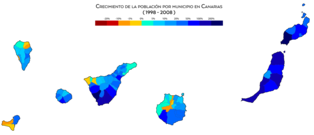
Population growth by municipality between 1998 and 2008

Population growth by municipality between 2008 and 2018


Population by islands

According to INE data as of January 1, 2022:
- Tenerife: 931 646 hab.
- Gran Canaria: 853 262 hab.
- Lanzarote: 156 112 hab.
- Fuerteventura: 120 021 hab.
- La Palma: 83 439.
- La Gomera: 21 798 hab.
- El Hierro: 11 423 hab.
The following table presents the 20 municipalities with the largest population according to the INE municipal register of 2019, in yellow are the municipalities belonging to the province of Las Palmas and in blue those belonging to the province of Santa Cruz of Tenerife:
Economy

The economy is based on the tertiary sector (74%), mainly tourism, which has led to the development of construction. Only 10% of the surface is cultivated, the majority being rainfed (barley, wheat, vines and potatoes), and a minority (bananas and tomatoes) irrigated, oriented towards trade with the rest of Spain and with the European Union.
Although at first the Canary Islands were outside the Customs Union of the European Economic Community, this regime of commercial freedom made it impossible to subsidize the agricultural production of tomatoes and bananas because the CAP (Common Agrarian Policy) was not applicable to it, For this reason, the change to a full integration model was requested and obtained, with the establishment of an Excise Tax on the importation of merchandise and a reduced VAT, the IGIC. Among the tax specificities of the Canary Islands is the Reserve for Investments in the Canary Islands (RIC), which reduces the taxable base of Corporation Tax (IS) to 90% of undistributed profit (80% in the case of professionals who must pay for Personal Income Tax (IRPF) for the amount of the allocation to the reserve, which must be invested within three years from the allocation.Likewise, there is a free zone, called the Canary Islands Special Zone (ZEC), where the established companies are taxed at 4% of the IS.
However, as cited, the Canarian economy is strongly based on the service sector. The export economy established by the European colonizers after the conquest in the 15th century, generated large commercial movements and travelers for decades. The first foreign visitors, mainly North-Europeans, were quickly attracted by the beneficial climatic qualities of the archipelago.
So, prior to the current mass tourism model, there is a tourism of privileged minorities in the Canary Islands, of elites who are interested in the weather, botany and tranquility of this location. Travel for health reasons, for health reasons, is one of the first engines that launched the tourist factory. Puerto de la Cruz was the place where tourism began in the Canary Islands. In 1886, the first sanatorium in the Canary Islands was established in this small port in the Valle de La Orotava to accommodate sick tourists. It was also the first Spanish tourist center in Europe.
Subsequently, the phenomenon called the tourist boom arose throughout the Archipelago as a consequence of the appearance of a demand typical of modern societies, the culture of leisure and consumption. The tourism boom is the result of the consolidation of the welfare society of the mid-XX century, after World War II. In the Canary Islands, to adjust the economic system to the new expectations, the real estate-tourism development process is put into operation. That is why the construction sector is the one that has contributed the greatest growth in the last decade, but is currently facing a recessive cycle.
The Gross Domestic Product (GDP) in the Canary Islands in 2015 was 40,922,914 million euros. The figure by islands is as follows:
- Tenerife - 17 614 585
- Gran Canaria - 15 812 222
- Lanzarote - 3 203 394
- Fuerteventura - 2 298 120
- La Palma - 1 422 949
- La Gomera - 393 845
- The Iron - 177 799
Tourism

The Canary Islands are the second Spanish region that receives the largest number of foreign tourists, behind Catalonia. The Canary Islands receive more than 11.5 million foreign tourists annually (Record for the year). In this aspect Tenerife, according to the data provided by AENA, is the main tourist destination on the islands, with 37% of the total, followed by Gran Canaria with 31% and then Lanzarote and Fuerteventura with 16.28% and 13. 30% respectively. La Palma remains in the proportion exceeding 1.3%. The main tourists who visit the islands come from northern Europe, mainly from the United Kingdom and Germany.
The Canary Islands enjoy international prestige in tourism research, analysis and education, through its two universities, as evidenced by the recognition of the Campus of International Excellence: University of La Laguna (ULL) and University of Las Palmas de Gran Canaria (ULPGC). The ULPGC integrates the Institute of Tourism and Sustainable Economic Development, which is among the top 30 in the world in scientific production in tourism.
Statistics
The number of tourists who visited the Canary Islands was around 15,976,000 in 2017, 16,150,054 in 2018 and 15,589,290 in 2019.
The distribution by destination island was (in 2017) (in millions):
- Tenerife - 5,93
- Gran Canaria - 4,48
- Lanzarote and La Graciosa - 2,93
- Fuerteventura - 2,22
- La Palma - 0,29
- La Gomera and El Hierro - 0.13
| Month | Lanzarote | Fuerteventura | Gran Canaria | Tenerife | La Palma |
|---|---|---|---|---|---|
| 2020 March | 99 407 | 71 988 | 141 692 | 208 696 | 11 531 |
| 2020 February | 215 054 | 175 618 | 387 432 | 528 873 | 31 996 |
| 2020 | 209 769 | 149 140 | 405 208 | 512 153 | 36 618 |
| 2020 | 524 230 | 396 746 | 934 332 | 1 249 722 | 80 145 |
| 2019 December | 256 733 | 168 717 | 416 723 | 526 258 | 35 515 |
| 2019 November | 231 995 | 159 352 | 405 715 | 487 576 | 29 614 |
| 2019 October | 258 722 | 175 472 | 354 718 | 484 905 | 24 506 |
| 2019 September | 235 534 | 154 056 | 291 855 | 432 241 | 21 106 |
| 2019 August | 273 783 | 175 153 | 328 921 | 501 712 | 26 465 |
| 2019 July | 270 438 | 171 819 | 333 530 | 481 976 | 22 059 |
| 2019 June | 242 901 | 159 945 | 274 881 | 451 244 | 18 266 |
| 2019 May | 230 821 | 140 370 | 261 250 | 423 740 | 19 447 |
| 2019 April | 256 776 | 179 318 | 324 647 | 484 097 | 32 927 |
| 2019 March | 295 614 | 201 556 | 447 905 | 579 224 | 39 570 |
| 2019 February | 272 428 | 164 970 | 403 123 | 513 880 | 32 162 |
| 2019 January | 239 830 | 172 468 | 424 117 | 522 601 | 42 043 |
| 2019 | 3 065 575 | 2 023 196 | 4 267 385 | 5 889 454 | 343 680 |
| 2018 December | 258 185 | 171 248 | 420 041 | 519 566 | 34 266 |
| 2018 November | 256 755 | 163 189 | 410 456 | 513 953 | 40 401 |
| 2018 October | 265 950 | 207 176 | 397 411 | 541 492 | 27 865 |
| 2018 September | 249 877 | 181 272 | 326 673 | 451 957 | 22 094 |
| 2018 August | 260 216 | 206 718 | 370 232 | 516 048 | 28 054 |
| 2018 July | 258 746 | 208 723 | 374 844 | 485 961 | 23 453 |
| 2018 June | 233 824 | 181 406 | 301 068 | 448 667 | 19 384 |
| 2018 May | 245 563 | 159 808 | 285 178 | 421 763 | 22 702 |
| 2018 April | 266 433 | 184 772 | 347 043 | 488 679 | 30 675 |
| 2018 March | 299 270 | 223 478 | 441 620 | 572 515 | 35 369 |
| 2018 February | 246 215 | 181 218 | 396 707 | 484 485 | 40 282 |
| 2018 January | 222 283 | 184 199 | 438 555 | 503 856 | 50 215 |
| 2018 | 3 063 317 | 2 253 207 | 4 509 828 | 5 948 942 | 374 760 |
Infrastructures and services
Health

The Canary Islands Health Service (SCS) is an autonomous body of an administrative nature attached to the Department of Health of the Government of the Canary Islands, created by Law 11/1994 of July 26, on Health Regulation of the Canary Islands and whose organization and operation are regulated in Decree 32/1995. Most of the Canarian hospitals are operated by the Canarian Health Service.
Hospitals of the Canary Islands Health Service

The main hospitals in the archipelago belong to the Canary Islands Health Service, these are:
- Hospital Nuestra Señora de los Reyes (El Hierro)
- Hospital General de La Palma (La Palma)
- Hospital Nuestra Señora de Guadalupe (La Gomera)
- University Hospital Complex Nuestra Señora de Candelaria (Tenerife)
- University Hospital Complex of the Canary Islands (Tenerife)
- University Hospital Complex Doctor Negrín (Gran Canaria)
- University Hospital Complex Insular Materno-Infantil (Gran Canaria)
- Hospital General de Lanzarote Doctor José Molina Orosa (Lanzarote)
- Hospital General de Fuerteventura Virgen de la Peña (Fuerteventura)
Education
In terms of education, the Canary Islands have had the University of La Laguna (ULL) in the city of San Cristóbal de La Laguna (Tenerife) since 1927. This university is the oldest in the Canary Islands. The other university in the Canary Islands is the University of Las Palmas de Gran Canaria (ULPGC) in Gran Canaria. This last university was created on April 23, 1989, from the Polytechnic University of the Canary Islands (now extinct) and the University of La Laguna itself.
In 2012, the first private higher education institution in the Canary Islands opened its doors, the European University of the Canary Islands, located in La Orotava (Tenerife). In 2015, the Fernando University joined the private offer Pessoa Canarias in Gran Canaria, and in 2016 the Universidad del Atlántico Medio, with double headquarters in Las Palmas de Gran Canaria and Santa Cruz de Tenerife.
On the other hand, the first and oldest active institute in the archipelago is the IES Canarias Cabrera Pinto located in the city of San Cristóbal de La Laguna in Tenerife, a city in which the headquarters of the School Council of Canary Islands. In addition, the archipelago has the Conservatory of Music of the Canary Islands, structured in two locations, one in Santa Cruz de Tenerife and another in Las Palmas de Gran Canaria, governed by the same common body.
Transportation

Internal communications are by road. Gran Canaria and Tenerife have a system of highways and highways, there are two sections in Lanzarote and a highway is under construction in Fuerteventura. There are no train tracks, except for the Tenerife Tram, whose line 1, which connects Santa Cruz de Tenerife with San Cristóbal de la Laguna, entered service on June 2, 2007. It currently has two lines. project three routes that would unite, on the one hand in Gran Canaria, the capital with Maspalomas through the Gran Canaria Train, and on the other hand in Tenerife, Santa Cruz de Tenerife with Los Cristianos through the South Train and with Los Realejos thanks to the Tren del Norte.
Between the islands you can travel by plane, with regular lines operated by the companies Binter Canarias and Canary Fly, as well as the ferry, fast ferry or catamaran maritime lines, run by the companies Fred Olsen and Naviera Armas.
From the Iberian Peninsula and the rest of Europe, regular and charter planes are mostly used. There are also weekly maritime lines with Cádiz, Funchal and Huelva. as in number of passengers and in volume of merchandise), the Tenerife South Airport, the César Manrique Lanzarote Airport and the Tenerife North Airport. In total, the Canary Islands register a movement of 16,874,532 inbound passengers through its eight airports. The two capital islands (Tenerife and Gran Canaria) are the ones that register the greatest influx of passengers; Tenerife 6,204,499 passengers and Gran Canaria 5,011,176 passengers.
Imports and exports are carried out mainly by sea. The islands have a special tax regime within the European Union (Outermost Regions).
Government and politics

The Canary Islands were established in 1982 as an Autonomous Community of Spain by means of Organic Law 10/1982, of August 10, on the Statute of Autonomy of the Canary Islands. The Statute establishes that the powers of the Community are exercised through the Parliament (unicameral, exercises the legislative power), the Government (which exercises the executive power) and its president. In addition, each major island has its own administration in the form of Island Councils. The representation of the State resides as in all the autonomous communities in the Government Delegation, with headquarters in Las Palmas de Gran Canaria.
The Parliament of the Canary Islands, based in Santa Cruz de Tenerife, is made up of 70 regional deputies elected by universal suffrage. Tenerife and Gran Canaria elect 15 deputies each; La Palma, Fuerteventura and Lanzarote, 8 each; and La Gomera and El Hierro, 4 and 3 deputies respectively; in the last elections a regional list with 9 deputies was added. Its functions are the elaboration of laws that affect the Community, the approval of the autonomous budgets, the control of the regional government, the appointment of the senators that correspond to the Canary Islands (who join those directly elected by the citizens in each insular constituency), etc.
The X Legislature of the Parliament of the Canary Islands began on June 25, 2019 with the holding of the constitutive session of the chamber where the 70 parliamentarians elected in the elections of May 26 of the same year took office.
| Parliamentary groups in the Parliament of the Canary Islands | |||||
| Name | Members | Spokesperson | Autonomic leader | Scalls | |
|---|---|---|---|---|---|
| G.P. Canary Socialist | María Dolores Corujo Berriel | Angel Víctor Torres Pérez | 25 | ||
| G.P. Nationalist Canario (CC-PNC-AHI) |
| José Miguel Barragán Cabrera | Fernando Clavijo Battle | 20 | |
| G.P. People | Asier Antona Gómez | Asier Antona Gómez | 11 | ||
| G.P. New Canary Islands | Román Rodríguez | Román Rodríguez | 5 | ||
| G.P. Yes Can Canarias | Noemí Santana Perera | Noemí Santana Perera | 4 | ||
| Board | Casimiro Curbelo Curbelo | Casimiro Curbelo Curbelo | 3 | ||
| Vidina Espino | Mariano Cejas | 2 | |||
The Government of the Canary Islands, with offices in Santa Cruz de Tenerife and Las Palmas de Gran Canaria, exercises executive power and is made up of the president (highest political authority in the community) and the councilors who are in charge of the various councils. The president of the Canarian government is Ángel Víctor Torres, of the PSOE.

Santa Cruz de Tenerife
- Other institutions
The Common Deputy of the Parliament of the Canary Islands, based in Santa Cruz de La Palma, is the Canarian Ombudsman. He is a high commissioner appointed by the Parliament of the Canary Islands, whose purpose is to defend the constitutional rights and freedoms of Canarian citizens. The Economic and Social Council of the Canary Islands, based in Las Palmas de Gran Canaria, is the consultative body of the Parliament and the Government of the Canary Islands in socio-economic and labor matters. The Audiencia de Cuentas de Canarias, located in Santa Cruz de Tenerife, is the supervisory body for the accounts and economic management of the public sector in the Canary Islands. The Superior Court of Justice of the Canary Islands, based in Las Palmas de Gran Canaria, is the highest jurisdictional body in the Canary Islands, without prejudice to the Supreme Court. For its part, the Consultative Council of the Canary Islands has its headquarters in San Cristóbal de La Laguna, in Tenerife, and is the supreme consultative body of the Autonomous Community of the Canary Islands, with the same rank as the Common Deputy. The headquarters of the General Captaincy of the Canary Islands is located in Santa Cruz de Tenerife.
Territorial organization
The Autonomous Community of the Canary Islands is politically made up of two provinces, the province of Las Palmas and the province of Santa Cruz de Tenerife, created in 1927 when the province of the Canary Islands was divided, which since 1833 included the entire archipelago, with capital in the city of Santa Cruz de Tenerife. For its part, each province is made up of islands that function as political entities with their own administration and each one of them governed by a local government called the island council. In turn, each island with its own administration is made up of municipalities. In total, the Canary Islands have 88 municipalities.
The island of La Graciosa is the only island that does not have its own administration, it is administratively attached to the municipality of Teguise on the island of Lanzarote and is governed by the council of this island. The political members of the different municipalities, of the councils and of the Government of the Canary Islands are elected by direct universal suffrage of the citizens of each one of the eight islands. The islands with their own administration, in alphabetical order, with the number of municipalities that comprise it, their corresponding capitals, surfaces and population are:

| Island with own administration | Flag | Shield | Municipalities | Capital | Area (km2) | Population (2020) |
|---|---|---|---|---|---|---|
| The Iron | 3 | Valverde | 268,71 | 11 147 | ||
| Fuerteventura | 6 | Puerto del Rosario | 1665.74 | 119 732 | ||
| Gran Canaria | 21 | Las Palmas de Gran Canaria | 1560,10 | 855 521 | ||
| La Gomera | 6 | San Sebastian de La Gomera | 369.76 | 21 678 | ||
| Lanzarote | 7 | Arrecife | 888.07 | 155 812 | ||
| La Palma | 14 | Santa Cruz de La Palma | 708,32 | 83 458 | ||
| Tenerife | 31 | Santa Cruz de Tenerife | 2034.38 | 928 604 |
Capital
Currently, the Canary Islands is the only autonomous community in Spain that has two capitals: Las Palmas de Gran Canaria and Santa Cruz de Tenerife. This has been since the creation of the Canary Islands Statute of Autonomy in 1982.
The political capital of the archipelago did not exist as such until the 19th century. The first cities founded by Europeans at the time of the conquest of the Canary Islands in the XV century were: Telde (in Gran Canaria), San Marcial del Rubicón (in Lanzarote) and Betancuria (in Fuerteventura). These cities held the first European institutions present in the archipelago, among them Catholic bishoprics. Although, due to the fact that the period of splendor of these cities developed before the total conquest of the archipelago and its incorporation into the Crown of Castile, they never had political and real control of the entire Canary archipelago.


The function of a Canarian city with full jurisdiction for the entire archipelago only existed after the conquest of the Canary Islands, although originally de facto, that is, without legal and real significance and linked to the headquarters of the General Captaincy of the Canary Islands.
Las Palmas de Gran Canaria was the first city to perform this function. This given that the residence of the Captain General of the Canary Islands was in this city during part of the 16th and 17th centuries. Later, in May 1661, the Captain General of the Canary Islands, Jerónimo de Benavente y Quiñones moved the headquarters of the captaincy to the city. from San Cristóbal de La Laguna on the island of Tenerife. This was due to the fact that since the conquest this island was the most populated, productive and with the most economic expectations. La Laguna would be considered the de facto capital of the archipelago until the XIX century., the then only Bishopric of the Canary Islands and the Inquisition.
Already in 1723 the Captain General of the Canary Islands Lorenzo Fernández de Villavicencio had transferred the headquarters of the General Captaincy of the Canary Islands from San Cristóbal de La Laguna to Santa Cruz de Tenerife.
In the middle of the XIX century, the official capital of the Canary Islands was confirmed to the city of Santa Cruz de Tenerife, due in part to the constant controversies and rivalries between the bourgeoisies of La Laguna and Las Palmas de Gran Canaria for the economic, political and institutional hegemony of the archipelago (see: Island lawsuit). It would be after the creation of the province of the Canary Islands in November 1833 in which Santa Cruz would become the first fully official capital of the Canary Islands (de iure and not de facto as was the case before). They established entities such as the Canary Islands Court of the Indies, the Canary Islands Development Board, the Postal Service and the Canary Islands Health Board, among others.
The 19th century was quite turbulent. Due to the constant controversies and lack of solidarity between islands, the province was divided by Royal Decree of March 17, 1852. This division lasted only two years, but the province would be divided again by Royal Decree on January 27, 1858, lasting a short time. On September 15, 1868 with the Glorious Revolution, the province was divided again, a division that lasted until December 14, 1868.
In 1912, with the Cabildos Law, an attempt was made to bring order to the matter by transferring provincial powers to the Island Councils, although the island dispute would continue latent and perhaps more alive than ever.
Santa Cruz de Tenerife would hold the status of capital of the Canary Islands until the government of General Primo de Rivera through the R.D. On September 21, 1927, the former province of the Canary Islands was divided into two provinces: Las Palmas with its capital in Las Palmas de Gran Canaria and Santa Cruz de Tenerife with its capital in the city of the same name. The Second Republic granted constitutional rank to said division. From this moment on, the capital of the Canary Islands does not exist, but rather two independent provinces, one from the other, each with its respective capital.
Finally, with the Statute of Autonomy of the Canary Islands in 1982 and the creation of the Canarian Autonomous Community, the capital status of the archipelago was established jointly between Santa Cruz de Tenerife (executive and legislative capital) and Las Palmas de Gran Canaria (executive and judicial capital), which is how it remains today.
In the Statute of Autonomy of the Canary Islands, in article 5. Capital and seat of the Presidency, the following is expressed:
"1. The capital of the Canary Islands is set in the towns of Las Palmas de Gran Canaria and Santa Cruz de Tenerife, and the statute of capital is regulated by law of the Parliament of the Canary Islands.The headquarters of the Presidency of the Canary Islands will alternate between the two capital cities for legislative periods.
The headquarters of the Vice-President shall be located in capital other than that of the Presidency.
2. The Parliament of the Canary Islands is based in the city of Santa Cruz de Tenerife»
Culture
Mixing
Society and the Canarian people are the product of multiple influences, with very diverse contributions. The cultural elements that characterize the Canarian people are the result of the open and mixed history that has marked the evolution of the islands. The Canarian culture has received, to a greater or lesser extent, contributions from the three continents bathed by the Atlantic (Africa, Europe and America), the islands being for centuries a land of arrival, stopover, exchange and emigration. All these contributions have been acclimated to the characteristics of the islands and their people, to form a rich and diverse cultural identity. Three fundamental elements come together in it: an indigenous substrate, of Berber origin; the European element, fundamentally Castilian, Andalusian and Galician, although with important Portuguese contributions and, to a lesser extent, Italian, Flemish, British or French; and, finally, the American influence, product of the commercial and migratory relations with Latin America, particularly with Cuba and Venezuela, countries for which many Canarians feel particular affection.
The Aboriginal Element

Despite the immigration, miscegenation and consequent acculturation that followed the conquest, which led to the loss of the languages of the aborigines and most of their culture, a certain aboriginal substratum is present in certain practices pastoral; in traditional games and sports (Canarian wrestling, stick wrestling, shepherd's jump); in some genres of musical folklore (tajaraste, sirinoque); in handicrafts, fundamentally in traditional Canarian ceramics, heir to the indigenous; in Canarian speech, especially in the lexicon referring to grazing, elements of nature (flora, fauna), anthroponymy and place names; in gastronomy, mainly through gofio and its culinary derivatives; in popular religiosity, as an element that is mixed with Christian rites in certain manifestations (Virgin of Candelaria, Festival of the Branch of Agaete, witchcraft, etc.). Also preserved in the collective memory, or collected by chroniclers from the time of the conquest or later, stories and legends that refer to the pre-Hispanic world (Holy Tree of Garoé, legend of Gara and Jonay, of Princess Ico, etc.).
It is worth highlighting, among the indigenous contributions to Canarian culture, the Gomeran whistle, the only whistled language that has been preserved on the islands since pre-Hispanic times, although it is currently adapted to the Spanish language. In addition to the direct contributions to the culture of the Canarians, "the Guanche" has had a fundamental symbolic value in the construction of the Canarian identity, as a primal and unifying element.
The European imprint
The Canarian society that was born after the conquest and colonization of the archipelago will be governed by parameters imported from Europe, mainly from the Castilian metropolis (Spanish language, institutions of Castilian origin, Christian religion, etc.). The contribution of the different Iberian peoples is present in a large number of Canarian cultural manifestations, although modified according to the internal evolution of the islands and local tastes. This influence appears, for example, in musical folklore (in genres such as seguidillas, isas or malagueñas, and in instruments such as the timple), in traditional clothing, in popular architecture, gastronomy, in the Canarian dialect, in the handicraft etc

The Portuguese influence is especially significant, especially in Canarian speech, which has inherited a fundamental part of its lexicon from the Portuguese language. Canarian architecture is also an example of this fusion between different Iberian elements, to which is added its own imprint (the importance of wood, the Canarian balcony, etc.), which will later travel to America.
Throughout their history, the islands have been a transit and arrival area for people from different parts of Europe, mainly related to commercial activities. Among those who have left a greater cultural imprint on the Canary Islands, it is worth noting the English, Flemish, Franco-Norman and Genoese, influences present above all in architecture and sculpture. However, the influences of these other European areas in the daily practice and customs of the population of the archipelago were minimal.
Separate mention deserves the cultural importance of the Christian religion, a fundamental element for the colonization of the islands. At present, the festivities in honor of each of the seven island patron Virgins stand out. The pilgrimages have become great manifestations of the "canariedad": festivals of religious origin in which the features of traditional culture (clothing, folklore, gastronomy, etc.) are exalted. However, many of the elements present in the pilgrimages are relatively recent, the most paradigmatic case being some of the "typical" clothes that are merely inventions and not really traditional costumes.
Along with traditional Christian festivities, carnival is the great festival of the Canary Islands, celebrated on the eight islands of the archipelago. The Canarian carnival has had to overcome times of restrictions and prohibitions, such as during the Franco dictatorship, during which period it was called the Carnival of Santa Cruz de Tenerife Winter Festival.
The American Influence
The cultural relationship between the Canary Islands and America has been "round trip", two-way. Canarian culture has had a special role in the construction of certain national identities, such as Cuban, Dominican, Puerto Rican, Venezuelan or Uruguayan, with the first settlers of cities such as Montevideo (Uruguay) and San Antonio (United States) being islanders., as well as one of the founders of São Paulo and Rio de Janeiro (Brazil) and several Municipalities of Puerto Rico. The canaries had a great impact on the economic development of the province of Santo Domingo (now the Dominican Republic) during the 18th century. In the opposite direction, the Canary Islands have inherited a large number of cultural manifestations and tastes from Latin America, mainly through the strong migratory link between the islands and that other side of the Atlantic. Thus, Canarian speech is related to the dialects of Caribbean Spanish, both in terms of pronunciation and lexicon.

In terms of gastronomy, it is worth noting the importance of the potato, which came from America, in the island's cuisine, both for the large number of varieties that are grown on the islands and for being the fundamental element of typical dishes such as wrinkled potatoes. In addition, on some islands the consumption of typical Ibero-American dishes such as the arepa has become widespread.
In the crafts, it is worth mentioning the manufacture of cigar-type cigar tobacco, on the island of La Palma.
In some parties we find reminiscences of the times of emigration, the most popular being the Carnival of the Indianos, on the island of La Palma. The music made on the islands also denotes Spanish-American influence, both in the "emigration genres" (habanera or Cuban punto among others) and in rhythms popularized on the islands, already forming part of the repertoire of famous Canarian music groups such as Los Sabandeños. o Los Gofiones (joropo, bolero, son, etc.).
Currently, the Canary Islands are one of the favorite destinations for the new Ibero-American emigration to Spain, finding Ibero-Americans, in the Canary Islands as in the rest of Spain, a noticeably warmer welcome than immigrants from other origins.
Recent Influences
The influence of the Franco dictatorship in the construction of new traditions, present above all in cultural manifestations such as pilgrimages or the so-called Canarian folklore, has already been mentioned previously.
The emergence of a left-wing nationalist movement in the 1960s led to the claim by them of an identity related to the Guanche or pre-colonial world, with a certain pan-Africanist character, in opposition to the official culture prevailing at that time. From there arises the use of a certain symbology by artists such as Martín Chirino or Tony Gallardo (initiator of the El Hierro Manifesto) and which will end up spreading among the Canarian population, thereby losing much of its original political significance. The pintadera and the spiral as symbols of Canarian identity, the recovery of practices in the process of disuse such as the shepherd's jump, now used as a leisure activity, etc. are related to these processes.
Currently, the higher economic and educational level of the population, the greater ease of travel, tourism (mainly Spanish peninsular, British and German), Ibero-American immigration, and globalization have provided new possibilities for miscegenation and additional cultural elements.
Religion


As in the rest of Spain, Canarian society is mostly Christian, mainly Catholic. The Catholic religion has been since the Conquest of the Canary Islands in the XV, the majority religion in the archipelago (for more than five centuries). Two Catholic saints were born in the Canary Islands: Pedro de San José Betancur and José de Anchieta. Both, born on the island of Tenerife, were missionaries in Guatemala and Brazil respectively. The Canary Islands archipelago is under the patronage of the Virgin of Candelaria.
However, the growing migratory flows (tourism, immigration, etc.) are increasing the number of followers of other religions who come together on the islands, such as: Muslims, evangelicals and practitioners of Hinduism. Minority religions Significantly important in the Canary Islands are: Afro-American religions, Chinese religions, Buddhists, Bahaism and Judaism. There is also a form of autochthonous neopaganism in the archipelago, the Church of the Guanche People.
The distribution of beliefs in 2012 according to the CIS Autonomous Barometer was as follows:
- 84.9 % Catholics
- 7.8 % non-believers
- 4.5 % atheists
- 1.7 % other religions
Among believers, 38.7% frequently attend religious services.
Catholic Dioceses
The Canary Islands are divided into two Catholic dioceses, each governed by a bishop. Both belong to the ecclesiastical Province of Seville:
- Diocese of the Canary Islands, also called Canariense Diocese-Rubicense: It includes the islands of the province of Las Palmas (Eastern province): Gran Canaria, Fuerteventura, Lanzarote and La Graciosa. It has its headquarters in the city of Las Palmas de Gran Canaria.
- Diocese of San Cristobal de La Laguna, also called Diocese of Tenerife or Nivarian Diocese: It includes the islands of the province of Santa Cruz de Tenerife (western province); Tenerife, La Palma, La Gomera and El Hierro. It has its headquarters in the city of San Cristobal de La Laguna.
Museums


Many of the insular museums of the islands have in their collections archaeological material and human remains from the prehistory of the archipelago, the history of the Canary Islands and science and technology. In Tenerife there is the Autonomous Organization of Museums and Centers of Tenerife, a local autonomous organization belonging to the Cabildo de Tenerife. Some of the most important museums in the archipelago are:
- Museum of Nature and Archaeology MUNA: It is an exhibition project that belongs to the Autonomous Agency of Museums and Centres, located in the heart of the city of Santa Cruz de Tenerife. Integrates Archaeological Museum of Tenerife, the Instituto Canario de Bioantropología and Museum of Natural Sciences of Tenerife. It is known for hosting a formidable collection of guanches mummies and for its high quality of preservation, it guards a large collection of objects related to the ancient aborigines of the Canary Islands (the guanches). It has one of the world's most demanding mummified human remains conservation and display systems. As far as it is also a global benchmark for mummies conservation.
- The Canary Museum: It is a scientific and cultural institution based in the city of Las Palmas de Gran Canaria. It is one of the main cultural institutions of the archipelago. Among the collections that it conserves deserve to be highlighted the ceramic containers for their varied typology and decorative beauty; the idols, with a wide representation for Gran Canaria; and the so-called pins, of which more than 200 pieces are available. This museum also has a large collection of bone remains from the ancient inhabitants of the island. It was founded in 1879 at the initiative of Gregorio Chil and Naranjo. It also has a rich documentation centre that preserves important elements of Canarian documentary heritage.
- Archaeological Museum of the Port of La Cruz: It is created in 1953, in the city of Puerto de la Cruz (Tenerife). It was created from the Instituto de Estudios Hispánicos de Canarias. It houses one of the most important aboriginal guanche ceramic collections in the Canary Islands with unique pieces in Tenerife.
- Museo de la Cueva Pintada de Gáldar: It is a museum located in the Cueva Pintada Archaeological Park, in the municipality of Gáldar (Gran Canaria). This cave was discovered in the centuryXIX, is a magnificent example of the artistic representations of the ancient aborigines of Gran Canaria. The museum was reopened on 26 July 2006, after more than twenty years of restoration work.
- Museum of Anthropology of Tenerife: It belongs to the Autonomous Agency of Museums and Centers. Its current headquarters is located in the Casa de Carta building in Valle de Guerra (in the municipality of San Cristóbal de La Laguna, Tenerife) and its main function is to investigate, conserve and spread the popular Canarian culture.
- Museo de Cetáceos de Canarias: It is located in Puerto Calero, within the municipality of Yaiza (Lanzarote). It was created to promote the knowledge, conservation and research of the natural heritage of the seabed of the Canary Islands. This museum is the first museum in Spain dedicated exclusively to cetaceans.
- Elder Museum of Science and Technology: It is located in Las Palmas de Gran Canaria and has 4500 m2 in which you can find: exhibition rooms full of interactive parts and modules. Workshops to perform live science and a large-format cinema projection room.
- Museum of Science and Cosmos: It belongs to the Autonomous Agency of Museums and Centres, was inaugurated in 1993 at the initiative of the Cabildo and the Instituto de Astrofísica de Canarias. It has its headquarters in San Cristóbal de La Laguna in Tenerife and its purpose is to bring to the public the discoveries that the study of the Universe is providing.
- Benahoarita Archaeological Museum: Located in Los Llanos de Aridane, this is the museum institution dedicated to the most important archeology of the island of La Palma. It is dedicated to the benahoarite culture, the Aboriginal people of the island.
- Centro Atlántico de Arte Moderno: It is a museum dedicated to contemporary art located in Las Palmas de Gran Canaria. Its main cultural policy is structured on the concept of “triontinentality”. It was opened on 4 December 1989.
- TEA - Tenerife Espacio de las Artes: Also located in the city of Santa Cruz de Tenerife seeks to promote the knowledge of the different trends of contemporary art and culture among the local and foreign population, promoting the organization of cultural, scientific, educational and technical activities.
- Museum of History of Tenerife: It belongs to the Autonomous Agency of Museums and Centers. It was opened in December 1993 in the property known as Casa Lercaro, in San Cristóbal de La Laguna (Tenerife). The museum is born with the vocation of spreading the history of the island of Tenerife, offering an overview of the island's institutional, socio-economic and cultural development since the centuryXV to the centuryXX..
Parties


Some of the holidays celebrated in the Canary Islands are international and national, others are regional holidays and others are insular. The official day of the autonomous community is Canary Islands Day on May 30. This day commemorates the anniversary of the first session of the Canary Islands Parliament based in the city of Santa Cruz de Tenerife, held on May 30, 1983.
The common festive calendar throughout the Canary Islands is as follows:
| Date | Name | Notes |
|---|---|---|
| 1 January | New Year | International holidays. |
| 6 January | Day of Kings | Catholic holidays. |
| March or April | Thursday and Good Friday | Christian holiday. |
| 1 May | Labour Day | International holidays. |
| 30 May | Day of the Canary Islands | Day of the Autonomous Community. Anniversary of the first session of the Parliament of the Canary Islands. |
| 15 August | Assumption of the Virgin Mary | Catholic holidays. This day is festive in the archipelago as in all Spain. Popularly, in the Canary Islands it is known as the day on which the Virgin of Candelaria (Patrona de Canarias) is celebrated. |
| 12 October | Hispanic Day | Spanish National Party. Commemoration of the discovery of America. |
| 1 November | All Saints | Catholic holidays. |
| 6 December | Constitutional Day | Commemoration of the referendum for the ratification of the Spanish Constitution. |
| 8 December | Immaculate Conception | Catholic holidays. The Immaculate Conception is the Patron of Spain. |
| 25 December | Christmas | Christian holiday. Commemoration of the birth of Jesus of Nazareth. |
In addition, each of the islands has an insular holiday in which it is a holiday only on that island in question. These are the festivals of the insular patron saints of each island. In chronological order they are:
| Date | Island/s | Virgin |
|---|---|---|
| 2 February | Tenerife | Our Lady of Candelaria |
| 5 August | La Palma | Our Lady of the Snows |
| 8 September | Gran Canaria | Our Lady of Pino |
| 15 September | Lanzarote and La Graciosa | Our Lady of the Dolores |
| Third Saturday of September | Fuerteventura | Our Lady of the Peña |
| 24 September | The Iron | Our Lady of the Kings |
| Monday following the first Saturday of October | La Gomera | Our Lady of Guadalupe |
Apart from these, each of the 88 Canary Islands municipalities celebrate as local holidays the festivities of their patron saints throughout the year. There are also more local festivities in the Canary Islands that are very popular throughout the archipelago. In this section, the pilgrimages and descents of some island patron saints every few years stand out. Among which can be mentioned; the Pilgrimage of Socorro in Güímar, that of San Benito Abad in San Cristóbal de La Laguna, that of San Roque in Garachico and that of the Virgin of Candelaria in the homonymous municipality, all of them in Tenerife. In Gran Canaria, the pilgrimages of Teror dedicated to the Virgen del Pino, the Bajada de la Rama in Agaete and the pilgrimage in honor of San Antonio de Padua in Mogán stand out. In Lanzarote and Fuerteventura, the pilgrimages of the insular patron saints stand out: the pilgrimage of the Virgen de los Dolores and the Virgen de la Peña respectively. In the Canary Islands, the pilgrimages are the most important festivals in each town. People usually dress up in traditional Canarian clothing, which varies depending on the island or area. They are festivals where the canariedad manifests itself and where it is used to taste typical products. In the rest of the islands, the descents of the insular patron saints stand out, such as the Lustral Festivities of the Bajada de la Virgen de las Nieves in La Palma every five years, the Bajada de la Virgen de los Reyes in El Hierro every four years and that of the Virgin of Guadalupe in La Gomera every five. On the island of La Graciosa, for its part, the maritime procession of its patron saint, the Virgen del Carmen, is celebrated every year on July 16.
Carnivals
Without a doubt, carnival is the most well-known and international party in the archipelago. Carnival is celebrated on all the islands and all its municipalities, perhaps the two most crowded are those of the two Canary capitals; Santa Cruz de Tenerife and Las Palmas de Gran Canaria. But the rest of the islands of the archipelago have their carnivals with their own traditions;
- Fiesta de los Carneros de El Hierro; The young people of the village of La Frontera are attacked with the skins of rams, obtained months and even years ago and are dedicated to running after the smallest and not so small, to scare them and to embadurn them of black dye.
- Fiesta de los Diabletes de Teguise en Lanzarote; This is a popular tradition produced by the mixture of aboriginal beliefs with Castilian elements and witchcraft connections born mostly since the end of the centuryXV. The figure of the diablete appears in Teguise, incarnated in the goat, symbol of virility and fertility. At this party, certain people's neighbors are disguised as devils. Another distinctive feature of the carnival in Lanzarote is the Arrecife bugs.

- The Indians of La PalmaIt is undoubtedly the most important act of the Carnival of Santa Cruz de La Palma. This tradition dates back to the centuryXIX from the celebrations celebrated with the arrival to the port of the ships from Cuba and the rest of Hispanoamérica. It was called “indians” to the islanders who had emigrated and returned to the island boasting of wealth and prosperity stories. It is now a tradition that those who disguise themselves as Indians are devoted to throwing talc powders to all participants and visitors.
- Carnival of Las Palmas de Gran Canaria; It is the largest popular festival and one of the most massive in the capital city of Gran Canaria and one of the most important in the country. In the holidays the Queen's Choice Gala and the Carnival Drag Queen's Choice Gala are celebrated.
- Carnival of San Sebastian de La Gomera and Carnival of Puerto del Rosario (Fuerteventura); The carnivals of the capitals of the island of La Gomera and Fuerteventura have acts similar to those of the carnival of Tenerife and Gran Canaria as the parades and the gala of choice of queen of the carnival. In Puerto del Rosario highlights Achipencos a carnival race that takes place in the village bay. These hydrodynamic carnival artillerys powered by clean energy make the delights of the public and has become the most unique act of the carnival of the capital majorera, and the one that most attendees gathers.
- Carnival de Santa Cruz de Tenerife; On January 18, 1980 it was declared International Tourist Interest Party, being together with the Carnival of Cadiz the only carnivals in Spain that possess such a distinction. The carnival of Santa Cruz de Tenerife is considered one of the most important in the world. It highlights the Grand Gala of the Election of the Queen of Carnival, as well as numerous parades for the capital avenues, the Carnival of Day and the burial of the sardine.
Media
Press
Apart from the nationally distributed newspapers, some of which, such as ABC, include regional news pages, the main newspapers published in the Canary Islands are, in alphabetical order: Canarias7, Diario de Avisos, El Día and La Provincia. La Opinión de Tenerife was published until 2019, when it announced its closure. There are also some digital newspapers such as Canarias24horas, Canarias Ahora, Canarias Semanal or Bienmesabe and its own news agencies such as ACFI PRESS or ACN Press.
Television
In addition to the national channels, in the Canary Islands there is a public regional television, TV Canaria, which is part of the Federation of Autonomous Radio and Television Organizations (FORTA), an organization made up of the Spanish regional television and radio stations. There are two other regional private television concessions, granted to Antena 3 Televisión de Canarias and Popular Televisión Canarias. There are also numerous island and local television stations.
Radius
The main national radio stations can be tuned in the Canary Islands, many of them with local disconnections in their programming. In addition, there are numerous local and municipal radio stations. Among the local stations, Radio Club Tenerife (the oldest radio station in the Canary Islands), Radio ECCA, dedicated to distance education and whose diplomas are approved by the Government of the Canary Islands, 7.7 Radio, the first to broadcast its content in digital format and Canarias Radio, the last of the public radio stations to be created in Spain.
Contenido relacionado
Miami
Occidental Sahara
Tolosa (Guipuzcoa)