
Bulnes orange tree
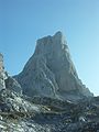
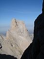
The Naranjo de Bulnes (in Asturian Picu Urriellu) is a limestone peak of Paleozoic origin located in the Urrieles Massif in the Picos de Europa, in Asturias (Spain). Administratively, Naranjo de Bulnes is located in the Asturian council of Cabrales and within the Picos de Europa National Park.
It has an altitude of 2519 m and, although it is not the highest peak of the Cantabrian mountain range, it can be considered one of its best known mountains, as well as one of the emblematic summits of Spain. It stands out from the point of view of climbing on big walls, especially for the 550-meter vertical wall on its west face. At its base is the Vega de Urriellu, a valley of Quaternary glacial origin.
Toponymy
The first written reference to Picu Urriellu as "Naranjo de Bulnes" is due to the German engineer and geologist Guillermo Schulz, who in 1855 published the first topographic and geological map of Asturias. In any case, the origin of this name is not clear, which is neither the popular nor the traditional one, given that the inhabitants of the area historically always referred to the mountain as "Picu Urriellu". In fact, in the sketches that are conserved of said map, it can be seen that in principle, "Urriellu" is written correctly to later cross out the final letters, leaving it in "Urriel", then return to "Los Urrieles" and finally add "Naranjo de Bulnes". This sketch can be consulted in the June 1973 issue of "Torrecerredo", in which Patricio Ardúriz published a photocopy of said original Schulz sketch. Regarding the uncertain origin of this denomination, there are hypotheses that speculate with the possibility that the term "Naranjo" supposes the corruption of the millenary "Naranco", just as others defend that perhaps it is due to the orange color of the limestone from which It is formed by the minerals of the region.
Origin of the term Urriellu
The original name Picu Urriellu (['pi.kʊ‿u.'rje.ʎʊ]) derives from the root «Ur» of pre-Roman origin, which refers to to a ground elevation. From this same root derive many other place names scattered throughout the Asturian geography (Urru, Orru, Urriel, Urrieles, Urra, Urriellu).
Historical climbs

First climbs
The first climb was carried out on its north face (by what is currently known as Vía Pidal-Cainejo) on August 5, 1904 by Pedro Pidal and Bernaldo de Quirós, Marqués de Villaviciosa de Asturias, accompanied by the shepherd Gregorio Pérez Demaría "El Cainejo", a native of the town of Caín (León). The doctor in geology and experienced German mountaineer Gustav Schulze carried out the second ascent of Urriellu on October 1, 1906, also on the north face, which was the first solo ascent of the peak. He was also the first to use pegs to rappel down the south face. Accustomed to the long walls of the Alps and Dolomites, he rated this climb as short and difficult. Víctor Martínez Campillo, a native of the nearby town of Bulnes, ascended on August 31, 1916 along the same face and route as Pidal. During this climb, Víctor picked up part of the rope that Pedro and Gregorio had left embedded in the rock on their descent from the top. On September 22, 1923, Víctor repeated the same ascent.
1920s
On August 19, 1924, Víctor Martínez Campillo also opened a new, easier route located to the left of the South face, known as Vía Víctor. On July 7, 1928, Andrés Espinosa, a mountaineer from Biscay, ascended the South face alone and without a rope. This is the second ascent of these characteristics in the Picu, and the first at a national level. A month later, on August 8, 1928, Manuel Martínez Campillo (Víctor's cousin) opened a new road known as the Paso Horizontal. This route was located to the right of the south face and becomes one of the most used.
Mid 20th century
On August 13, 1944, two sons of Víctor Martínez (Alfonso and Juan Tomás) opened what is known as "Vía Sur" or "Directa de los Martínez" on the south face, one of the most used and safest. On March 23, 1954 Antonio Moreno, Rafael Pellús, Máximo Serna and Agustín Faus, from the Peñalara High Mountain Group, attempted the first winter climb. The attempt is frustrated by the threat of snow avalanches. On March 8, 1956, Ángel Landa Bidarte, belonging to the Baracaldo Alpine Tourist Group, and Pedro Udaondo, from the Juventus Mountain Group of Bilbao, managed to crown the peak for the first time in winter conditions. On August 21, 1962, the Aragonese mountaineers Alberto Rabadá and Ernesto Navarro ascended the Peak for the first time through the difficult west face.
Late 20th century
On February 8, 1973, two ropes formed by Miguel Ángel García Gallego ("Murciano") and José Ángel Lucas in one, and César Pérez de Tudela and Pedro Antonio Ortega ("Squirrel") in the other, get the first winter to the Rabadá and Navarro road (west face). This ascent was widely followed by the media, since this winter had claimed several lives and very spectacular rescues were carried out. On September 4, 2009, the Pou brothers (Iker and Eneko) completed in Urriellu, after eight hours of activity, the most difficult wall-climbing route in the world up to then: the Orbayu route, with an 8c+/9a grade.
How to get to the base

There are many ways to reach the Vega de Urriellu area. Perhaps the easiest is to leave the car in the town of Sotres. From there, walking along the existing track, you have to go to the Cabao winters; then you cross the river Duje and from there you go up almost to the Pandébano pass, where the track ends and the path begins. Once on the path, you have to go up to the Collado de Pandébano, a place from where you can already see the Urriellu and, following the obvious path, head for the Terenosa sheepfold (where the refuge of the same name is located). From this area we reach the Colláu Vallejo, where the route turns south. From there, the route zigzags up to Vega de Urriellu, where the Urriellu refuge is located at an altitude of 1,960 metres.
The Pandébano pass can also be reached from the town of Bulnes, which can only be accessed by funicular or path. Although the most direct way to get to Vega de Urriellu from Bulnes is through the Balcosín channel and the Camburero sheepfold, on the contrary, this path is more difficult.
Climbing routes


List of the most important routes. It must be taken into account that these, in turn, have input and/or output variants.
West face
- Rabadá and Navarro (750 m, MD+, 6th, A1 [6c+]).
- Leiva (500 m, 7a / [6b, A1]).
- Sagittarius (200 m, 6b) opened in September 1985 by Higinio Giraldo and Andrés Villar (Villareto).
- Direct (500 m, 7b / [6a, A2]).
- Murciana 78 (500 m, 7c+ / [6a, A2]).
- Mediterranean (500 m, 6b, A3]).
- Pilar del Cantábrico (500 m, 8a+ / [6a, A2+]).
- Orbayu: The most difficult route in free climbing so far open on a mountain. The road was opened by the Pou brothers in September 2009 (500 m with difficulty of 8c+ and 9th in one of their lengths).
- Sagittarius, 200 m.D. opened by Higinio Giraldo and Andrés Villar (Villareto) in October 1985.
- Galiciando, (500 m. E.D.), 6b+/A2, finished in September 2018 after several visits working the wall by Rubén Suarez, Ynma Regueiro and Andrés Villar, (Villareto)
South West Spur.
- Finisterrae, 160 m. M.D.Sup. max. 6b. open by Jonay Pérez Rubén Suárez and Andrés Villar, (Villareto)
- Luar, 165 m. M.D.Sup. 6B/A1, opened in May 2002 by Rubén Suárez and Andrés Villar (Villareto)
North face
- Régil (700 m, V).
- Pidal-Cainejo (450 m, V) (first ascension to the Orange, August 5, 1904).
- Pánico Terminal, 690 m, M.D.Sup., 6b, opened in August 1989, by Salvador Muñoz and Andrés Villar.
- The Turquoise Goddess (1100 m, the longest of Orange, V* 85o, mixed climbing, ice / rock, 3rd route open in winter to the Urriellu, is the combination of several routes united to the same summit of the mountain, opened in February 1990 by Salvador Muñoz and Andrés Villar (Villareto)
- Centenary, commemoration of the first climb to the Orange of Bulnes in 1904, 670 m. 6b+/Ao, in July 2003, by Rubén Suárez and Andrés Villar. (Villareto)
- Quixote 4th Centenary, open in memory and celebration of the 4th centenary of the great writer Cervantes, in October 1985 by Pablo Fadeville, Rubén Suarez and Andrés Villar (Villareto).
- The Last Link, opened in July 2009 by Ramón Figueira, Daniel Herráez and Andrés Villar, (Villareto).
- Human factor, opened over two years, finishing up in October 2013 by Ramón Figueira, Rubén Suárez and Andrés Villar, (Villareto).
East face
- Cepeda (350 m, 6a).
- Loco Bird (200 m, 6b).
- Martínez-Somoano (250 m, V+ expo).
- Friendship with the Devil (200 m, V+ expo).
- Cainejo (260 m, 7b / [6a+, A1]).
- Treparriscos, September 1985 by Higinio Giraldo and Andrés Villar.
- La Luna, November 1986, by Paulino Suárez and Andrés Villar.
- Carrusel, September 1988.
- Paparruchas, October 1988
- From which you go Plass, December 28, 1988, first open winter route to the Picu Urriellu, by Salvador Muñoz and Andrés Villar.
- Argentino and the Villareto, possibly the most difficult exit from the east wall, only 3 long covering the final collapse before the Eastern peak, opened by Ramón Figueira and Andrés Villar (Villareto).
- ``South/Eastern
- Twilight Celta, September 1985, by Higinio Giraldo and Andrés Villar.
South face
- Nani. (300 m, V+).
- Directa Hermanos Martínez (155 m, V-).
- Invicto and Laureado (160 m, 6a+, obl. 6a).
- I shelter in the drink (145 m, 7a, obl. 6c).
- Pecadillu (300 m, 6c, obl. 6b).
- Dawn uncertain, (V+, A1, 6a, V+, IV) in June 1986 by Higinio Giraldo and Andrés Villar.
- Rianoia, (IV+. 6a+, A2/6C, 6b) in June 1998 by Cecilio Fernández and Andrés Villar (Villareto)
- Tell the Sun(V+, V, IV+, IV), 185 meters, first winter on the south side, opened on January 3, 2019 by Sergio Pensado and Andrés Villar (Villareto)
The descent is done on the south face (via Sur Directa) with four rappels, after climbing down part of the Amphitheatre. It is a very decomposed area and there are loose stones. Currently there are more descent lines, on the western slope, along the Sagittarius and Murciana routes, with rings at all their meetings, there are also possibilities of descent along the Hawaii route, although it is necessary to know it well to venture down it. On the east wall, via Espejismos de verano, a very direct line that begins in the upper steps of La Cepeda. There are other possibilities on the southern slope, but it is essential to know the terrain well as we can get out of line.

West face.
North face.

North face.
South face.


.jpg)
Contenido relacionado
Black forest
Maldives
Tonga