
Biscay
Vizcaya (officially and in Basque, Bizkaia) is a Spanish historical territory and one of the three provinces that make up the autonomous community of the Basque Country. Its capital and most populated city is Bilbao. It is located in the north of the Iberian Peninsula and borders the Cantabrian Sea to the north, Guipúzcoa to the east, Álava and Burgos to the south and Cantabria to the west. Vizcaya is a mountainous province, with a high population density and an oceanic climate, with abundant rainfall and mild temperatures.
It is made up of 112 municipalities organized into seven counties. With an area of 2,217 km², it is the second smallest province in Spain, but it is the tenth most populous (1,159,443 inhabitants) and the third in population density. population (518.55 inhabitants/km²). Most of the population lives in the Bilbao metropolitan area, which is the sixth largest metropolitan area in Spain. The official languages are Spanish and Basque; The western dialect of Euskera is autochthonous to Biscayan territory.
The territory of Vizcaya has its origins in the medieval lordship of Vizcaya, from which derive historical rights and a charter regime that are recognized by the Spanish Constitution. Thus, the Provincial Council of Vizcaya, like the rest of the Basque Provincial Councils, has a much greater autonomy than that of the rest of the Provincial Councils. Like other Spanish provinces, it has its own regional law. Vizcaya was one of the first industrial centers in Spain and had a highly developed iron and steel industry since the end of the XIX century; Altos Hornos de Vizcaya was the largest company in the country for almost the entire XX century. However, the oil crisis of 1973 had very profound economic consequences in Vizcaya, and the province underwent a process of profound industrial conversion.
Toponymy
Etymology
The term Vizcaya or Bizkaia has a disputed etymology. For some it means top, and would be a synonym of the current Basque word bizkar ("hill"). In the year 1141, in reference to the top of Mount Igueldo in San Sebastián, the following place name appears inscribed: Iheldo Bizchaya ("Cima de Igueldo""). Also in Navarra there is a region called "La Vizcaya", which can mean "The top". Other etymologies have also been proposed, such as bits-kaia ("port of foam") or bizi-kaia ("living port"), less probable, since there are similar place names in places far from the sea, such as the aforementioned Navarra or Labets-Biscay.
Denominations
Bizkaia
Bizkaia is the denomination in Basque recommended by the Royal Academy of the Basque Language, commonly used in official documents in this language. It is used in official documents of the Spanish Administration (it has been the only official name since 2011), also in documents in Spanish, and is the most used by the Spanish-language media in the Basque Country. It is also the name used in the version in Basque of the Spanish Constitution and in the Basque version of the Statute of Autonomy for the Basque Country.
Although it is the only official denomination approved for the historical territory by its General Assemblies by means of Foral Regulation 12/1986, of December 15, of the General Assemblies of Vizcaya, on Signs of Identity of the Historical Territory of Bizkaia, as said Provincial Regulation did not affect the name of the province, since Royal Legislative Decree 781/1986, of April 18, which approved the consolidated text of the legal provisions in force in matter of local government, provided in its article 25.2 that "only by law approved by the Cortes Generales can the name and capital of the provinces be modified", Vizcaya continued to be the only official name of the province according to the Royal Decree of November 30, 1833 until the year 2011.
On June 29, 2004, the Basque Nationalist Party Parliamentary Group presented bill no. 122/000084 in which he proposed establishing Bizkaia as the sole official name. This proposal was eliminated by that same Parliamentary Group on May 9, 2006 due to lack of support.
In 2011, the budget agreement reached by the PSOE and the PNV in the Congress of Deputies included the current name change, through which the only official name of the Biscayan territory would be Bizkaia.
Vizcaya
Vizcaya is the name in Spanish, recommended by the Royal Spanish Academy. It can be used in non-official documents and, in general, in the Spanish-speaking written field. It is also the name that was used in the Spanish version of the Spanish Constitution of 1978 and in the Spanish version of the Statute of Autonomy of the Basque Country of 1979.
History
Prehistory and Antiquity
There is evidence of Paleolithic settlement in several places in Biscay, such as the caves of Bolinkoba (Abadiano), Arenaza (Galdames), Atxeta (Forua), Santimamiñe (Cortézubi) and Lumentxa (Lequeitio).
The presence of several forts from the Metal Age, such as those of Arrola, Malmasín or Bolumburu, suggest an occupation of the territory by Indo-Europeans. Current archeology opines:
"In the cultural and architectural aspects, the cultural situation is parallel to that known in any of the geographical regions of the Basque Country, with the same differences and internal peculiarities that can be found in them."
Romanization
In Ptolemy's distribution of pre-Roman tribes, it encompasses the northern part of ancient pre-Roman Caristia and Autrigonia. In those of Strabo, Pomponius Mela and Pliny the Elder, it corresponds to the western part of the territory of the Varduli. The parentage of these three tribes is unknown. Historians discuss its Cantabrian, Basque, Indo-European, Celtic or Celtiberian origin without there being conclusive evidence in favor of any of these hypotheses.
Autrigons
The Autrigones, who in Vizcaya would occupy the Encartaciones, were not mentioned by Strabo. Other Roman historians such as Pomponio Mela and Pliny the Elder place them inland, in the northern part of the current province of Burgos (Briviesca). Pliny the Elder around the year 77 cited "among the ten cities of the Autrigones Tricius (Tritium Autrigonum) and Virovesca (Briviesca) as the capital of the Autrigones".
Ptolemy places them bordering on the Cantabrians to the west and Turmogos to the south, and with Caristios and Berones to the east, and, according to this distribution, they would extend between the Asón River and the Nervión River. Its main city was Virovesca (Briviesca), one of the mints of the Iberian horseman's coins. Other important cities were Tricio, in La Rioja; Deóbriga (Miranda de Ebro) and on the coast Flaviobriga (Castro-Urdiales) (although Pliny assigns this city to the Várdulos) the last colony founded by the Romans in Hispania. Other settlements were Osma de Valdegovia, Poza de la Sal and it is possible that at the mouth of the Nerua river (Nervión) they had a port since Roman coins were found in the Portugalete bar and in Bilbao. Floro and Orosio say that they were frequently attacked by the Cantabrians, which is why they possibly collaborated with Augusto in the Cantabrian wars and as a reward they obtained control of new territories on the Cantabrian coast, almost reaching the Deva River.
It is disputed whether they were related to Cantabrians, Celtiberians or Basques. The former is doubtful since it was the attack by the Cantabrians against the Autrigones and Turmódigos that started the Romano-Cantabrian war. The fact that some of its cities have the ending briga seems to indicate a Celtic origin.
Caristios
The Caristians occupied the rest of Vizcaya, according to Ptolemy. They are not mentioned by Strabo, nor by Pomponio Mela, but they were mentioned by Pliny the Elder, who calls them Carietes and places them in the interior, in the southern part of what is now the Basque Country.
Ptolemy places them between the Deva River, in the province of Guipúzcoa, and what is now Bilbao, reaching the Ebro from the south. Their territory bordered on those of the Várdulos and that of the Autrigones. Its cities were Tullica (perhaps Yours on the banks of the Zadorra), Suessatio (which could be the current Zuazo) and Veleia (which could be the current Iruña-Veleia), the last two were on the Roman road from Bordeaux to Astorga.
In this case, it is also disputed whether they were related to Cantabrians, Celtiberians or Basques.
Roman remains

Numerous remains of the Romanization of Vizcaya have been found, such as the remains of the coastal settlements of Lequeitio, Portuondo or Bermeo, perhaps the most important being the river port of Forua and the remains of its Roman settlement.
Middle Ages
From the fall of the Roman Empire until around the year 1000, there is very little historical information on Vizcaya. It probably suffered the devastation of the Héruli, since the chronicler Hydatius reports that 400 Héruli in seven ships attacked the Cantabrian and Vardulia coast in the year 456.
Ad own redeuntes headquarters, Cantabriarum et Vardaliarum loca maritima crudelissime deproedatio sunt.Fontes Hispaniae Antiquae, IX, p. 74
The latest archaeological investigations seem to indicate a Franco-Aquitanian expansion in Vizcaya from the VI century, which contradicts the historiographical proposals that are based on a continuity of culture from protohistory to the beginning of the Middle Ages:
In short, it is observed that between the late and the preceding world there is a rupture of settlement patterns. It is only a reflection of the profound changes experienced by the social structure, derived from the demographic recession that affected all of Europe, but also from the political events related to the frank expansion that, starting in the sixth century, had to affect the Basque Country, according to the characteristics of the archaeological record.
The relationship with the Merovingian Franks would be explained through the Duchy of Vasconia.
Neither the invasions of the Visigoths nor those of the Muslims seem to have reached Vizcaya, although its coasts were probably devastated by the Vikings, speculating on the possibility of a Viking settlement in the vicinity of Mundaca, which could be the origin of the legend of Jaun Zuria.
After the Muslim invasion, it is believed that Vizcaya fell under the orbit of the kingdom of Asturias, with some clashes which would be reflected in the also mythical battle of Padura. In the chronicle of Alfonso III of Asturias, written in the IX century, and referring to the reign of Alfonso I, is where makes reference to Vizcaya for the first time: "Alava, Vizcaya, Alaon and Orduña had always been possessed by their inhabitants", so there was no need to repopulate it; on the other hand, it did "populate" Sopuerta and Carranza (that is, he placed the west, Las Encartaciones, under his control).
The birth of lordship
After the annexation of the County of Castilla by Sancho III of Navarre (1029), Vizcaya came under the influence of the Kingdom of Pamplona; until the year 1040, when Íñigo López Ezquerra, Count of Vizcaya who governed the nuclear Vizcaya (without the Encartaciones or the Duranguesado), in the confrontations between Castile and Navarre, allied himself with the King of Castile, taking advantage of it to become hereditary lord of Vizcaya.

In 1135 the nuclear Biscay returned to Navarra's orbit, definitively passing to that of Castile in the year 1180. The Encartaciones continued in the Kingdom of Castile and the Duranguesado continued in that of Navarre, until the year 1200, when it passed to depend on Castile. At the end of the 13th century and in the XIV the succession in the lordship is altered by dynastic differences and by intervention in the affairs of the kingdom of Castile, where the lords of the house of Haro had fiefdoms and were related to noble houses such as the Lara or the real home.
The Lordship of Vizcaya, by maternal inheritance, in 1370 fell to the Infante don Juan de Castilla, who inherited the kingdom of Castile from his father, like Juan I, remaining since then linked to the crown, first to that of Castile and then, from Carlos I, to that of Spain, always on the condition that the Lord of the day swore to defend and maintain the privileges of the lordship (Biscayan own laws) which in their text affirmed that the Biscayans, at least in theory, could disobey the Lord that he did not do so.
Flagship Wars
The late medieval crisis affected Vizcaya, producing a decrease in agricultural production, famines, etc. Added to this crisis was the Black Death epidemic of 1348. Many peasants died, and others took refuge in the villas, which affected the income of the main houses.
Attempts to maintain their prestige and the search for income led lineage heads to power struggles that gave rise to two factions: Oñacinos and Gamboínos, led by the Oñacinos by the Lord of the House of Mújica, and the Gamboínos by the House of Urquizu de Abendaño. Thus began the wars of factions that devastated Vizcaya from the Late Middle Ages to the beginning of the Modern Age. The other lineages of Vizcaya were attached to one side or the other depending on their interests, the change of side being normal. The lords did not hesitate to rob towns considered enemies, to loot and extort their peasants, or to assault the convoys of merchants from Burgos who were heading to the ports to export their goods.
Las Encartaciones, in 1394, adopted the Fuero de Avellaneda, to fight against the social conflict generated by the violence of the banderizos. The farmers of Tierra Llana and the Villas went to King Enrique III of Castile, Lord of Vizcaya, to ask him for authorization to form a Brotherhood to protect themselves from the outrages of the jaunchos. The king, in 1393, commissioned the corregidor Gonzalo Moro, to draft new Brotherhood Ordinances, which is done in the General Meeting, but these ordinances were not applied due to the opposition of some lords of the Oñacino side.
In the middle of the XV century, the fights between banderizo lords become a power struggle between them, who dominate the Flat Land, on the one hand, and the Villas and the City on the other. In 1479, in the Junta de Villas meeting in Durango, he agreed to form a new brotherhood for the Villas. And in 1480 it was agreed that, in order to pacify Vizcaya, a commission would be formed with representatives of the towns of Bilbao, Bermeo, Lequeitio and Durango and members of the Butrón, Múgica, Abendaño and Arteaga lineages to settle the complaints and put an end to the fights.
The flag wars ended at the end of the XV century when the Count of Haro and Duke of Frías, a Velasco, wanted to take advantage of the opportunity and invaded Vizcaya to seize it with the acquiescence of the Castilian king, his enemy the Count of Treviño managed to unite Oñacinos and gamboínos who faced Velasco in the battle of Munguía, getting rid of both the desires of the great aristocrats like the fights of the local jauntxos. The placing of the Villas under administrative control of the Crown, the strength of the Brotherhoods of the villas and the recognition of universal nobility to all Biscayans were important elements in the loss of power of the lords. On the other hand, the values of the banderizos gentlemen (nobility, honor, honour) came to be considered typical of the Biscayan society, and, added to other imported customs, such as the Castilian ancestry blended with Biscayan uses and customs, reinforced the idea of a Biscayan identity of its own.
Medieval charters
Medieval Biscay was divided into three parts with their own government and jurisdiction:
- The Llana Earth, understanding plains in the sense of no walls, that is, the fields and hamlets in the nucleus of Vizcaya, with the vizcaíno and infanzón, organized in merindades and anteiglesias and celebrating their joints in Guernica.
- The Incartations, with their own jurisdiction (out of the Incartations) and government and which held their Boards in Avellaneda.
- The Merindad de Durango, with Durango, who held together in the Campa Foral de Guerendiaga in front of the hermitage of San Salvador and San Clemente de Abadiano.
As towns and cities were endowed with town charters and private jurisdictions during the XII and centuries ="font-variant:small-caps;text-transform:lowercase">XIII, they ceased to depend on the privileges of Vizcaya, Encartaciones or Durango, and began to celebrate their Meetings separately. The towns and the year they were granted charters were: Valmaseda (1199), Bermeo (1236), Lanestosa (1287), Plencia (1299), Bilbao (1301), Ochandiano (1304), Portugalete (1322), Lequeitio (1325), Ondárroa (1327), Areatza (1338), Marquina (1355), Elorrio (1356), Guernica (1366), Durango (1372), Ermua (1372), Miravalles (1375), Munguía (1376), Larrabezua (1376) and Rigoitia (1376); the city is Orduña (1228).
Las Villas and the City, Las Encartaciones and the merindad of Durango only attended the General Meetings of Guernica, sending representatives when they were going to discuss common issues that affected them.
The birth of the navy

...the smallness or narrowness of the country, its wealth in iron ore, its ancient abundance of forests and its geographical location have made that, from a precise moment of the Middle Ages to the Contemporary Ages, the Basques have distinguished themselves not only as fishers of height and as ferrets, but also as seamen, builders of wood and industrial ships in general. Sea, forest and iron decisively conditioned the Basque life.Caro Baroja
In 1068 Sancho II of Castile granted the episcopal see of Oca permission to fish in several Cantabrian ports. It is believed that, between the end of the century IX and the beginning of the X population, which had abandoned the Biscayan coastal strip for fear of Viking attacks, it reoccupies it and the towns and settlements that we know today appear. But there are no written references until the year 1082, in the donation of the hermitage of San Miguel in Bermeo: «et illa ecclesia S. Micaelis arcangeli in portu de Vermelio, in ora maris, cum suos morturos ad illa pertinente». This repopulation is slow. Fishing and commercial ports developed from the XII and XIII.
Bermeo received his charter in 1236, becoming Head of Biscay, and in 1296 he became part of the Brotherhood of the Villas de la Marina de Castilla with Vitoria.
Referring to Bermeo, a document from 1269 mentions “five cabins” on the seashore, which seems to indicate that fishing activity was still seasonal. But it also describes more important installations, and says that there are two ports, a major and a minor, and that the minor can be closed with a chain. He also mentions two other anchorages called Arcaeta and Portuondo, which would probably be in the Mundaca estuary. Bermeo and other coastal towns would become important fishing and commercial centers until the disaster of the Black Death in the summer and autumn of 1348.
In these ports, fishing activity became increasingly important, especially whaling. And the fact that they were the natural ports for the export of iron from Biscay and Castilian wool to England, France, Flanders and the Baltic countries also turned them into trading ports.
In the XIII century, there is evidence of factories in the Bilbao estuary and in the major ports. As early as the XIV century, lawsuits were filed between Ondárroa and Lequeitio and between Lequeitio and Marquina over the use of forests, whose trees They are needed for shipbuilding. Although they cannot be considered shipyards, ships are built in Ondárroa in Icaran, in Lequeitio next to the banks of the Lea River. In Bermeo in 1357 the convent of San Francisco was located near "the suburb where the nabes are made", that is, in the area called Ribera and in Bilbao boats are built on the banks of the estuary. In the XV century, the shipyards were consolidated, and their operation became regulated at the same time as the appearance of auxiliary industries such as ironworks or ropes that are installed in its vicinity. In Lequeitio the shipyard is in the southern part of the Plaza del Astillero, in Bermeo in the Ribera, in Plencia in the cemetery, Ondárroa and Berriatúa share a shipyard and ships were faired in Amallo, Rentería and Asánsolo. But the greatest boom in shipyards is in Bilbao, where from the current San Antón Bridge to Portugalete there are a multitude of slipways, factories and beaches, becoming XV the center of shipbuilding in Biscay. As it is an obligatory crossing point between Orduña and Bermeo, Bilbao gradually loses prominence from Bermeo to become the most important port and town from Biscay. In the 15th century, the Bilbao shipyards and the wool trade with France and Flanders were very important. And in the 16th century, Portugalete rivaled the port of Bilbao.

Modern Age
During the war, the Communities of Castilla Vizcaya remained completely calm. On July 30, 1520, one of its cities, Bilbao, sent a letter to Carlos I assuring him of the fidelity of the entire province. Centuries later, there were some revolts in Vizcaya, for example: Rebellion of the salt (century XVII), Matxinada (XVIII< century).
Contemporary Age
_-_Prisonniers_espagnols_amen%C3%A9s_devant_don_Carlos,_de_Vierge.jpg)
The War of the Convention with the Spanish monarchy led to the French invasion of Biscay in 1794 and their withdrawal with the Peace of Basel in 1795. A little later (1808) the Spanish War of Independence led to new confrontations. The population opted overwhelmingly for Fernando VII and throughout the war, the province was the scene of violent combat. In 1808, in the span of three months (August 6-November 2), Bilbao changed hands six times and suffered a revolution, a great battle and two extensive lootings. In 1812 the situation was repeated, due to the offensive of the Seventh Spanish Army, which occupied and lost Bilbao several times. At the same time, the guerrillas in the province numbered several thousand combatants who harassed the invaders incessantly.
The succession of King Ferdinand VII started the Carlist Wars; in Vizcaya there were two, between 1833-1840 and between 1872-1876. Most of Vizcaya supported Carlism but Bilbao supported the Liberal government and was besieged by the Carlists who failed to take it (see: Bilbao sieges of 1835, 1836 and 1874).
.jpg)
The end of the last war meant for Vizcaya the loss of most of its autonomy (the «foral abolition» of 1876), although the province was compensated with the «Economic Agreement», a similar fiscal and administrative regime of its own which Navarra had enjoyed since 1841. It was also the beginning of the unlimited exploitation of the iron mines (which the foral regime limited as a treasure); thus Vizcaya became an industrial country with important consequences: depletion of the mines after a century (a large part of the mineral goes to England, where coal comes from); Massive immigration of workers from other regions of Spain who live in miserable conditions, especially on the left bank of the estuary (conflicts between workers and bosses and formation of two communities: native = Basque, and immigrant = "maketos"); Formation of large fortunes (Ybarra, Chávarri, Lezama-Leguizamón,...) (in addition to English, French or Belgian capital) that invest a large part outside of Vizcaya (which becomes a capitalist center of Spain: Banco Bilbao and Banco Vizcaya today united in BBVA).

After the Carlist defeat, Sabino Arana, a Biscayan from a wealthy Carlist family, created the Basque Nationalist Party at the end of the 19th century (right-wing, Catholic) that became one of the major parties in Vizcaya (together with the "Spanish" right and left) when the Spanish monarchy fell with the proclamation of the Second Republic (1931). In 1936 the autonomy statute was approved.
The Spanish civil war, between 1936 and 1939, left Vizcaya almost isolated from the government of Madrid, which allowed the Government of Euzkadi, based in Bilbao, a wide autonomy. But the defeat of the forces loyal to the republic (bombing of Guernica), brought the Franco regime: repression of everything that was left, "red", or "separatist" (ie, Basque nationalist); Declared a "treasonous province" by the Franco regime, Vizcaya lost the rest of its autonomy.
During the 1950s and, above all, the 1960s, coinciding with the stage of the Spanish economic miracle (1959-1973), there was the second great wave of immigrants from the rest of Spain who They moved to the Basque Country in search of work. Their high number and their mixture with the natives (part of whom came from the first wave of immigration at the end of the XIX century)) produced the current Basque society.
After Francoism died, like Franco, of old age in 1975, with a society that wanted to be "European", and not "different" like Francoism, came the current democracy: Spanish Constitution of 1978 and autonomy with the Statute of Autonomy of the Basque Country of 1979, which establishes Vizcaya as a "historical territory" with a certain autonomy.
Heraldry

The traditional coat of arms of the Señorío de Vizcaya shows the wolves of the Haro family, which recall the battle of Padura, and an oak tree, which is identified as the Tree of Guernica, headquarters of the Juntas, to which a cross was added.
The official coat of arms, defined by a Provincial Regulation, does not include the wolves, but says «Notwithstanding the provisions of this Provincial Regulation, the existing coats of arms will be maintained in those buildings characterized by their historical-artistic value, as well as like the currently existing banners as members of the History of the People of Vizcaya", which allows the coexistence of the two shields, the traditional and the official one.
The municipal heraldry of Vizcaya incorporates in numerous armories the motif of the tree and the wolves, associated with original elements as well as religious allusions, especially crosses of Saint Andrew and figures of Saint Michael the Archangel; plant motifs such as the typical panelas, the branches of oak, holm oaks or holly; heraldic animals, in particular the lion, sometimes used as an external support, but also marine animals such as the whale; constructions such as towers, castles and bridges, or the arms of noble families associated with the history of each municipality. In some cases, the traditional Biscayan arms are also combined with those of the Castilian crown. The economic activities of agriculture and fishing are also evoked, together with the heavy and naval industry.
Geography
.png)
Vizcaya is located in the north of the Iberian Peninsula, bordered to the west by the autonomous community of Cantabria, to the south by the province of Burgos and the historical territory of Álava, to the east by Guipúzcoa and to the north by the Cantabrian Sea (Bay of Biscay).. Its orography is very rugged as it is in the area where the Cantabrian Mountains meet the Pyrenees. It is the fifth most mountainous province in Spain if the average slope of the terrain is taken into account.

The extension of the province is 2,217 km². Land perimeter: 167 km, maritime: 80 km.
The climate is temperate, oceanic, with a lot of cloudiness throughout the year. Abundant and frequent rainfall, especially in autumn and winter, with an annual average of 1200 mm. The temperatures are mild both in summer and winter (14-15 °C annual average).
The main access roads include the AP-8 Autovía/Autopista del Cantábrico and the AP-68 Autopista Vasco-Aragonesa.
Provincial boundary

Demographics
According to the INE 2019 census, Vizcaya has 1,152,651 inhabitants, and its population density is 519.91 inhab/km²; only surpassed by the Community of Madrid and Barcelona. Fifth Spanish province by population in 1981, despite the demographic crisis it has been suffering since the Transition, it is still the ninth Spanish province in number of inhabitants. Due to the fact that since the beginning of the 1980s it has presented a strong negative migratory balance towards other regions of Spain, in 2009 it had only 5.7% of foreigners, at least six points less than the national average.
| Post | Municipality | Inhabitants |
|---|---|---|
| 1. a | Bilbao | 346 843 |
| 2. a | Baracaldo | 100 881 |
| 3. a | Guecho | 77 946 |
| 4. a | Santurce | 45 853 |
| 5. a | Portugalete | 45 766 |
| 6. a | Basauri | 40 589 |
| 7. a | Lejona | 31 795 |
| 8. a | Durango | 29 791 |
| 9. a | Galda | 29 326 |
| 10. a | Sestao | 27 296 |
| 11. a | Erandio | 24 350 |
| 12. a | Amorebieta-Echano | 19 339 |
| 13. a | Munguía | 17 691 |
| 14. a | Guernica and Luno | 17 016 |
| 15. a | Bermeo | 16 765 |
| 16. a | Ermua | 15 880 |
| 17. a | Sopelana | 13 878 |
| 18. a | Arrigorriaga | 12 160 |
| 19. a | Valle de Trápaga | 11 985 |
| 20. a | Echévarri | 11 563 |
| Population developments in Vizcaya and percentage compared to national total | |||||||||||||||||||
|---|---|---|---|---|---|---|---|---|---|---|---|---|---|---|---|---|---|---|---|
| 1857 | 1900 | 1910 | 1920 | 1930 | 1940 | 1950 | |||||||||||||
| Population | 160 579 | 311 361 | 349 923 | 409 550 | 485 205 | 511 135 | 569 188 | ||||||||||||
| Percentage | 1.04 % | 1.67 % | 1.75 % | 1.91 % | 2.05 % | 1.96 % | 2.02 % | ||||||||||||
| 1960 | 1970 | 1981 | 1991 | 2001 | 2011 | 2019 | |||||||||||||
| Population | 754 383 | 1 043 310 | 1 181 401 | 1 156 245 | 1 132 616 | 1 155 772 | 1 152 651 | ||||||||||||
| Percentage | 2.47 % | 3.07 % | 3.13 % | 2.93 % | 2.75 % | 2.45 % | 2.45 % | ||||||||||||
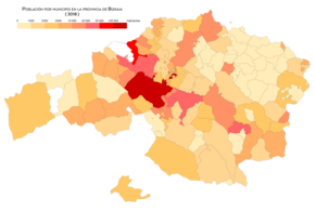
Population by municipality (2018)

Population density by municipality (2018)
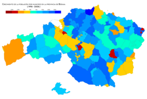
Population growth by municipality (1998 - 2008)

Population growth by municipality (2008 - 2018)


The twenty most populated municipalities in Vizcaya are those indicated in the table. Data obtained from the National Institute of Statistics in 2019. Note: the official name of the municipalities is not the currently official one according to the National Institute of Statistics. Vizcaya occupies the 32nd position of the state as a whole in which there is a higher percentage of inhabitants concentrated in its capital (30.10%, compared to 31.96% of the total).
Administration and politics
The institutions and foral bodies of Vizcaya, as a historical territory of the Basque Country, are the General Meetings of Vizcaya and the Provincial Council of Vizcaya.
General Meetings

The General Meetings of Vizcaya are the unicameral assembly that exercises the normative power of the historical territory of Vizcaya. Its members, called "proxies", are elected by direct popular suffrage. Elections take place every four years, coinciding with municipal elections, in four constituencies. The General Meetings of Vizcaya have their plenary hall in the Casa de Juntas de Guernica, and offices in Bilbao. The composition of the Boards after the 2015 elections is as follows:
Elections to the 2019 General Boards | ||||
| Political party | Powered | |||
|---|---|---|---|---|
| Euzko Alderdi Jeltzalea - Basque Nationalist Party | 25 | |||
| EH Bildu | 10 | |||
| Euskadi-Euskadiko Ezkerra Socialist Party | 8 | |||
| We can. | 6 | |||
| Popular Party of the Basque Country | 2 | |||
Provincial Council of Vizcaya

The Provincial Council exercises the executive function and regulatory power within the sphere of competence of Vizcaya.
The Provincial Council of Vizcaya is made up of a general deputy, currently Unai Rementería (PNV), elected by the General Assemblies, and by the other deputies (not necessarily members of the General Assemblies) designated by the general deputy, up to a maximum of ten.
Legality control
The regulations emanating from the General Meetings are called regional regulations and are the product of the legislative power with which the General Meetings are invested. For its part, the Provincial Council can issue regional decrees, of a similar category to the royal decrees of the central government. Both regional regulations and regional decrees have regulatory status and are therefore subject to legality control by the ordinary courts, with the exception of regional fiscal regulations, which, by decision of the Constitutional Court, have the status of law and they can only be controlled accordingly by this same court.
Culture
Gastronomy
Basque gastronomy enjoys a well-deserved reputation, not only because of the prestige that chefs like Juan Mari Arzak have achieved in recent times, but above all because of the variety and roots of a very extensive popular recipe book. As far as Biscayan cuisine is concerned, closely related to its Gipuzkoan neighbor, well-known dishes such as cod in pil-pil or Biscayan style, marmitako, Bilbao-style ratatouille, squid in ink or hake ondarresa. A good example of the importance of gastronomy in Biscayan and Basque society is the abundance of gastronomic societies (known as txokos in Biscay).
.jpg)


Monuments and places of interest
- Santurce
- House of Guernica Boards and Tree of Guernica
- Las Encartaciones y Museo de las Encartaciones
- Cave of Pozalagua
- Bridge of Vizcaya
- Cave of Santimamiñe and Oma Forest
- Euskalduna Palace
- Gaztelugatxe and Aquech Island
- Puerto de Bermeo and Puerta de San Juan
- Torre Ercilla, Church of Santa Eufemia and convent and church of San Francisco
- Church of Santa Maria de Axpe
- Urdaibai Biosphere Reserve and Mundaca Beach
- Natural park of Urkiola
- Basilica of the Assumption of Our Lady of Lequeitio
- Basilica of Our Lady of Begoña
- Lejona Campus of the University of the Basque Country
- Old and classic Car Museum of Loizaga Tower
- Bilbao Airport
- Hermitage of San Pedro (Abrisketa)
- Urdaibai Bird Center Orniological Museum
Contenido relacionado
Mount Katahdin
Sabadell
Burgos Province