
Biobío River
The Biobío River is a natural water course that crosses and divides the central zone and the southern zone of Chile and is one of the main ones in that country, both due to its geographical characteristics and its economic and historical importance.
Path
It is born in the Galletué lagoon and Icalma lake, in the extreme northeast of the Araucanía Region in the Andes mountain range, near the international border with Argentina. From there, it runs through a large part of the southern part of the Central Valley, crossing the provinces of Biobío and Concepción, in the Biobío Region. Finally, it ends in the city of Concepcion.
The Biobío River rises on the west bank of the Galletué Lagoon, in the national reserve of the same name. The river advances in an easterly direction and, a few kilometers ahead, the river receives the waters of the nearby Icalma lake. It slowly begins to turn its course to the northwest, meandering through the Andean valleys and receiving the flows of some smaller rivers, such as the Lonquimay, Rahue and Ránquil. The "Alto Biobío" begins to enclose itself in the pre-Andean slopes, increasing the speed of its waters.
When entering the intermediate depression, the river runs between flat slopes increasing from 60 to 120 meters wide, reducing its speed which allows navigation in some areas. Already in its middle course, the Vergara river ends in the vicinity of Nacimiento, draining a large southern part of the basin by receiving water from rivers such as the Malleco and the Renaico, which constitute a drainage network parallel to the Biobío in a northwesterly direction for a large part. from the northern mountain range of the Araucanía Region.
To the east of the Cordillera de la Costa, near the cities of San Rosendo and La Laja, the Laja River flows into, the main tributary of the Biobío considering its flow. The river continues its course, increasing its width considerably, reaching two kilometers when it flows into the Pacific Ocean, between San Pedro de la Paz and Hualpén, in Greater Concepción.
The Biobío is the second longest river in Chile, with a length of 380 km, and is the main channel of the third largest hydrographic basin in the country (after the Loa and the Baker). Several important rivers, such as the La Laja river and the Malleco are tributaries of the Biobío. It corresponds to the widest river in the country, with an average kilometer, being crossed in the metropolitan area of Concepción by four bridges: Biobío Railway Bridge (1889), Juan Pablo II Bridge (1973), Llacolén Bridge (2000) and Presidente Bicentennial Bridge. Aylwin (2011). Until 2010 it was also crossed by the Old Bridge (1942).
- The river at its pass through the basin

Near Concepción in 1903, when it was still navigable

During his passage through Alto Biobío.
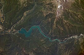
Satellite image of the river and the Pangue hydroelectric power station.

Dawn in meander between Hualqui and Chiguayante.

I pass by Quilaco.


In its course, the Biobío borders the communes of Lonquimay, Alto Biobío, Quilaco, Santa Bárbara, Los Ángeles, Negrete, Nacimiento, Laja, San Rosendo, Santa Juana, Hualqui, Chiguayante, San Pedro de la Paz, Concepción and Hualpen.
Flow and regime
To describe the Biobío regime, it is necessary to divide the basin into sectors:
- the Alta del Biobío subbasket that spans from the birth of the river Bío Bío until before the meeting with the river Lirquén, including the river Lonquimay, has a rainy regime – nival with great growths in July and November, product of precipitation and dehydration respectively. The stowage period occurs in the quarter January, February, March, because the precipitations are fairly low and the use of water for irrigation.
- the average subbasket of the Biobío, which includes from before the board of the Lirquén River to the board with the Vergara River, including the tributaries Bureo, Mulchén, Lirquén and Duqueco, has a rainfall regime, except the main channel that maintains a rainfall – nival regime. The period of stowage is common to the entire subfall and is observed in the January-March quarter, due to the low rainfall and the intensive use of water for irrigation.
- the lower sub-basket of the Biobío, which includes from the board with the river Vergara to its estuary in the Pacific Ocean, including the river Nicodahue, has a flood regime with large growths in June and July, and low flows in the quarter January-March, due to the low summer precipitation and the use of water for irrigation.
- the sub-basket of the Vergara, covers the watershed of the river Vergara and its tributaries, which are the rivers Malleco, Mininco and Renaico, has a netly rainy regime, with great growths in June, July and August. The period of stowage, common to the entire subfall, occurs in the January-March quarter, due to the low rainfall and the use of water for irrigation.
- the Laja subfall that covers the area drained by the river Laja and its tributaries, Rucue and Claro rivers has a net rainfall regime, with great growth in June and July, product to winter precipitations. Lower flow rates occur in the January-March quarter, mainly due to the intensive use of water for irrigation.
- Seasonal variation curves

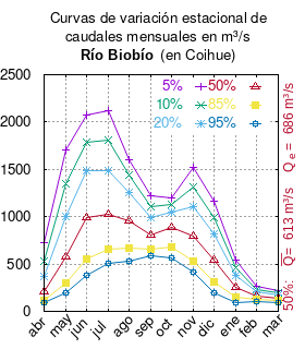


The flow of the river (in a fixed place) varies in time, so there are several ways to represent it. One of them is the seasonal variation curves that, after long periods of measurements, statistically predict the minimum flow that carries the river with a given probability, called probability of excess. The red ochre curve (with ♥ ♥ {displaystyle {color {Red}vartriangle }}) shows the monthly flow rates likely to exceed 50%. This means that the month has measured the same amount of flows greater than flows less than that amount. That is the median (statistical), which is denoted Qeof that month's flow series. The average (statistic) is the mathematical average of the flow of that month and is denoted Q! ! {displaystyle {overline {Q}}}.


Once calculated for each month, both values are calculated for the whole year and can be read in the vertical column on the right side of the diagram. The meaning of the 5% probability of exceedance is that, statistically, the flow is greater only once every 20 years, that of 10% once every 10 years, that of 20% once every 5 years, that of 85% fifteen times every 16 years and 95% seventeen times every 18 years. In other words, 5% is the flow of extremely rainy years, 95% is the flow of extremely dry years. From the season of the floods it can be deduced if the flow depends on the rains (May-July) or on the melting of the snows (September-January).
The river flow reaches almost 1000 m³/s on an annual average at its mouth.
History
The Biobío river has been a very important geographical landmark for the inhabitants of Chilean territory for years; it marked the northern border of the Mapuche tribes that inhabited central-southern Chile, separating them from the Picunches.
It was sighted by Juan Bautista Pastene in 1544. During the Conquest of Chile, Pedro de Valdivia and his successors founded various forts and cities in the Biobío basin, such as Concepción and Los Confines in order to advance south. After the disaster of Curalaba in 1598 and the development of the Arauco War between the Spanish troops and the Mapuche, the conquest of southern Chile stopped and Biobío remained the de facto limit between the two communities, being made official as such in 1647. For these reasons, the term La Frontera was coined to refer to the area around the river.
When the intensity of the Arauco war declined during the 18th and 19th centuries, the area began to be inhabited by the Creole population. Since 1861, the region around Biobío began to be heavily populated and during the 20th century various industrial economic activities were established.
Francisco Solano Asta-Buruaga y Cienfuegos wrote in 1899 in his Geographical Dictionary of the Republic of Chile about the river:
- BÍO-BÍO (Río).-—The most flowing and extensive in Chile. It has origin in the lake of Huepueltué or Gualletué for the 38° 45' Lat. and 71° 27' Lon. and will download in the Pacific for the 36° 49' Lat. and 73rd 11' Lon. After 256 kilometers of course, a mass of water, according to the geographer Pissis, of 2.808,000 cubic meters per hour. He leaves the two notable Moors to the N. of his mouth, known by the name of Tetas del Bío-Bío and the ports of Saint Vincent and Talcaguano. From its origin it runs through a valley between the Andes anticlinal chain and the Pemehue mountain range, which links to the S. with Mount Lonquimay, heading to the N. and NNO. until soon before arriving at the village of Santa Barbara, from where it twists towards the O. and goes down the sides of that villa, from San Carlos de Purén, Negrete and through the valley or central plain to the city of Birth; and from here it continues more or less to the NO., with several medium detours or turns, until its mouth, bathing the city of Concepción shortly before. Their margins are in their first high and quiet, and then lower, and they strip off of the woods in the passage of that plain; but from birth they rise again and grow thicker and thicker. Its bed in that section is moderately narrow to Piuluntué or the Rooms (see), where it closes and immediately opens in small arms and below contains islands (the largest is that of Diego Díaz), is covered by sand banks and opens in large width, which in front of Santa Juana, Tricauco, Concepción, &c. arrives at 1800 and up to 3000 meters. It is also notable for its raud course in most of its section to Birth; more, from here to the sea, it considerably diminishes its speed. In this extension of 130 kilometers and even slightly above that city, it is navigable by unheated vessels, despite the moving sand banks of its bed, but its mouth is obstructed by a shallow bar. On its shores there exist, from its birth, the populations and forts of Liucura, Lonquimay, Nitrito, Calaqui, Santa Barbara, San Carlos de Purén, Negrete, Birth, San Rosendo, Huenuraqui, Santa Juana, Talcamávida, Gualqui, San Pedro and Concepción; and there have been the strong of Munilque, Cayuhuenu, Santa Fe, Trinidad, Holy Spirit, It receives numerous streams of water of more or less caudal and course, of which the most notable, basing it, are: on the right, the Rahueco, Coliquén, Callaqui or Queuco, Duqueco, Guaque, Laja, Gomero, Quilacoya and Gualqui; and on the left, the Lorco, Recalhue, Quilavolo, Bureo, Vergara, It is marvelous at some points above the confluence of the Vergara; it has several passages of boats, and also cross it by magnificent bridges the railways of San Rosendo to Angol and of Conception to Colonel. This river, which unites the picturesque of its margins and valleys that cite it and the magestuous of its course, memories of the first battles of the conqueror Valdivia with the Araucanians, as well as of other marked acts of arms of conquest and independence, is also famous for having constituted, for a long time, the border strip with those Indians to the gang. The name comes from huihui or vyivyi, according to Fathers Febres and Rosales, altered in Bío-Bío by the Spaniards. The second of these authors says that the word means "the sound that the waves make when they grow thick, and that by doing (the river) waves like the sea (the Indians) they called him Byi-Byi" They also used the natural to say Vutanlcuvu, Gran Rio.
Luis Risopatrón describes it in his Diccionario geográfico de Chile (1924) about the river:
- Biobio (Rio) 37° 30' 72° 40’. It is born in the lagoon of Gualletué, at 1 163 m altitude, it runs towards the E, it is joined with the Rucanuco, desahue of the lagoon of Icalma, it is incorporated into the N, in the depression formed between the limiting cord with the Arjentina i la cordillera of Las Raices i presents narrowness of 15 to 20 m wide and 100 m long, between Lon It continues with 0.006 of approximate average slope, to the hamlet of Santa Barbara, after which the river widens 130 i 1 200 m, leaving in the margin S, stear formations of basaltic rocks; it crosses the central valley between bare shores of forests i decreases the current, which reaches only 5 km per hour in the vicinity of Birth, from where it begins to get drunk and where it is possible. It continues.to the NW, between the highest margins and more or less thick trees, has its widest, in front of Quilacoya, of 2 300 m i ends by emptying in the sea, to the S of the Bay of Saint Vincent; its mouth is obstructed by sand banks, which make the entrance impracticable with boats. It was, for a long time, the border line with the Araucanian Indians, in which numerous battles are remembered; the upper hole, up to the confluence of the Queuco river, comprises about 6 750 km2, the total hole, about 23 920 km2, its length about 380 km and its flow can be estimated, approximately, in 500 to 700 m3 of water per second. The Indians called it Ribimbi, Biu-biu, Buibui, Huihuy and Butanleuvu. 1, V, p. 479; i VI, p. 257; 3, i, p. 241, 10, p. 269; 61, XXIII, p. 129; 66, p. 248; Bío-Bío in 62, i, p. 90; 134; 155, p. 74; i 156; Colossus in 15, II, p. 71 (1710); i Conception in 3, i, p. 637 (Aldo).
In recent years, the area has become the second industrial center in the country (after Santiago), mainly in the forestry sector.
Population, economy and ecology
Contenido relacionado
Balkan peninsula
Visayas
Barbadillo