
Besaya (region)
The Besaya is a region of Cantabria (Spain). It is located in the center of the autonomous community and its capital is Torrelavega. The region runs along the Besaya River until its confluence with the Saja and the coastal area from this point to its mouth in Suances. It limits to the east with the region of Santander and the Valles Pasiegos, to the south with Campoo-Los Valles, to the west with the Western Coast and Saja-Nansa and to the north with the Cantabrian Sea.
Although there is already a regionalization law for Cantabria, it has not yet been developed, therefore the region has no real entity.
Municipalities of the region
| Municipalities of the region | |||||||
|---|---|---|---|---|---|---|---|
| Municipality | Population | Surface | Population density | ||||
| Anievas | 291 | 20,90 | 13.92 | ||||
| Arenas de Iguña | 1690 | 86.82 | 19,47 | ||||
| Bárcena de Pie de Concha | 687 | 30.53 | 22.5 | ||||
| Carts | 5742 | 19,01 | 302,05 | ||||
| Cieza | 536 | 44,07 | 12.16 | ||||
| The Corrales de Buelna | 10 912 | 45,38 | 240,46 | ||||
| Molledo | 1585 | 71.07 | 22.3 | ||||
| Polanco | 5850 | 12.7 | 460.63 | ||||
| San Felices de Buelna | 2421 | 36,24 | 66.8 | ||||
| Scope | 8645 | 24,56 | 352 | ||||
| Torrelavega | 52 034 | 35,54 | 1464.1 | ||||
Geography

Besaya hydrographic basin
The hydrographic basin of the Besaya River has an extension of 556 km², encompassing the municipalities of Campoo de Enmedio, Pesquera, Santiurde de Reinosa, San Miguel de Aguayo, Bárcena de Pie de Concha, Molledo, Arenas de Iguña, Anievas, Cieza, San Felices de Buelna, Los Corrales de Buelna, Cartes, Torrelavega, Polanco, Santillana del Mar, Suances.
The Besaya, like the main Cantabrian rivers, creates a valley transversal to the coastline that it channels through a large number of tributaries, among which the Bisueña, the Torina, the Erecia and the Llares. The waters from the Bárcenamayor mountain range, the Altos de Haro, Mediajo Frío, Castrucos, Cildá and the mountains of Tejas, Dobra, Orza, Pedrazo and Rebujas.
On its south-north route, the Besaya crosses permotriastics where the river is encased giving rise to Triassic sandstones, a "V" and steep slopes. It is in these sections, and depending on the marked unevenness, where some reservoirs have been installed, which have energy use.
On the other hand, outside of these sections, and especially in the middle and lower reaches, the Besaya runs through extensive plains that, at times of strong floods, give rise to catastrophic floods such as those of October 1983.
Currently
| Municipalities most populated in the region | |||||||
|---|---|---|---|---|---|---|---|
| Position | Municipality | Population | |||||
| 1o | Torrelavega | 54 827 | |||||
| 2nd | The Corrales de Buelna | 11 448 | |||||
| 3o | Scope | 8552 | |||||
The total population of the region reaches 93,487 inhabitants, according to INE data from 2013 (see table). According to data from the same year, its three most populated areas, from largest to smallest, are: Torrelavega (54,827), Los Corrales de Buelna (11,448) and Suances (8,552). And its three least populated centers, from smallest to largest, are: Anievas (333), Bárcena de Pie de Concha (739) and Molledo (1613). The latter coinciding with the southernmost part of the region.
Featured
|
|
Gallery

Allegory of mining, work of the sculptor Cantabri Jesús González de la Vega, in Torrelavega.

City of Torrelavega.

Facade of the Church of the VirginIn Torrelavega.
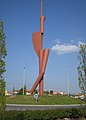
Balloon of boulevard round, in New City, with sculpture OteandoMiquel Navarro, in Torrelavega.

The peak Dobra seen from the town of Viérnoles (Torrelavega).
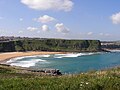
Playa de los Locos in Suances.
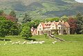
The Palace of the Hornillos in Arenas de Iguña.
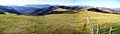
Panoramic view from the Tordian peakIn Arenas de Iguña.

Trailed by Bárcena de Pie de Concha.

Fiesta de la Vijanera in Silió (Molledo).


Contenido relacionado
For your
Run (print)
Saint John of Torres