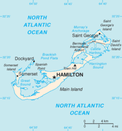
Bermuda Geography
Contenido keyboard_arrow_down
Bermuda, located in eastern North America, is an archipelago in the Atlantic Ocean, east of North Carolina (United States). Its location corresponds approximately to the antipodes of Perth, in Australia.
The archipelago is made up of some 360 coral islands, with a very rainy climate, but no freshwater rivers or lakes. The only water supply is that of the rain itself, which is collected by different means, such as, for example, on the roofs of the houses.
Geographic coordinates: 32° 20′ N, 64° 45′ W
Values
- Area
- Total: 58.8 km2
- Land: 58.8 km2
- Water: 0 km2
- Area - comparative
- Approximately 0.3 times the size of Washington D. C.
- Coastal line
- 103 km
- Maritime rights
- Exclusive fishing area: 200 mn
- Territorial sea: 12 nm
- Climate
- Subtropical; wet; strong winds frequent in winter
- Land
- Low mountains separated by fertile depressions
- Extreme heights
- Lowest point: Costa, 0 m
- Highest point: Town Hill, 76 m
- Natural resources
- Pleasant climate that attracts tourism
- Land use
- Arable land: 6%
- Other: 94% (55% developed, 39% rural/open) (est 1997)
- Natural hazards
- Hurricanes (between June and November)
- Environmental aspects
- Asbestos deposits; water pollution; preservation of open spaces
Contenido relacionado
Navigation (disambiguation)
Ledrada
Annex: Municipalities of Spain
Más resultados...
