
Barinas State
Barinas (from the indigenous noun meaning "Barinese wind" —a strong wind that comes from the Santo Domingo river valley—) is one of the twenty-three states that, along with the Capital District and the Federal Dependencies, form Venezuela. Its capital is the homonymous city of Barinas. It is part of the southwestern part of the country and occupies a large part of the western plains on the left bank of the Apure River, as well as a large part of the Andean foothills, in the eastern part of the Cordillera de Merida. Politically-administratively it is part of the Andes region and Los Llanos limits to the north with the states of Cojedes, Portuguesa and Trujillo; to the east with the Guárico state; to the south with the state of Apure and to the west with the states of Mérida and Táchira. With 35,200 km² it is the eighth entity by extension, and with an estimate of more than 1,009,125 inhabitants —and therefore a density of 37.3 inhab./km²— it is the eleventh by population and the seventeenth by population density; It is an important economic center of the Venezuelan plain, highlighting the cattle and oil industry.
It has been inhabited for more than three thousand years. The axis of development of the pre-Columbian cultures of the Western Plains was in their territory, with tribes from the Orinoco, the Amazon and the Andes. The Spanish colonization began in 1577 with the foundation of Altamira de Cáceres, a town from which the conquest of the Llanos began; there the Spanish benefited from the cultivation of tobacco, which gave prestige to its name but caused great problems of piracy and smuggling.
Its importance became such that in 1786 it was elevated to a province, as part of Venezuela. This was one of the most —or the most— faithful to the patriots in the War of Independence (1810-1823) and then to the liberals in the Federal War (1859-1963): there José Antonio Páez, hero of Independence, and Ezequiel Zamora, hero of the Federation. From this originated the national motto, "God and Federation."
It became a state in 1859 and was established by the Constitution of 1864; then it formed part of the Great Zamora State until 1899, the year in which it resumed its autonomy.
Toponymy
The name "Barinas" originates from the Santo Domingo River and its etymology is related to "great amount of water". In u'wa mythology, "Barima" (Santo Domingo) is one of the "routes to the great lagoons» (Atlantic).107
During the 16th century, the Spanish named the Santo Domingo River after the indigenous people of its upper course (Varinas or Barinas)109. This is expressed in the fifth chapter of the Historia (Aguado, 1582), as well as in the Elegías (Castilians, end of the century XVI):
Discover wide and beautiful fields,
With damage from the most neighboring nations;
They crossed the flowing rivers,
Guanaguanari, Tapia and Barinas;
The swirling Indians, bellicose,
They went out to the pilgrim nations
In plain field and in zavanas rasas,
In guard and defense of their houses.Estrofa 39, First Song, Elegía II: "To the death of George Espira, fourth governor of the provinces of Venezuela"
From c. 1592, this name of the river began to be used to name the original Altamira de Cáceres (1577-1628). The variety with "v" disappeared and the name spread, from its foundations, to Nueva Trujillo de Barinas (Barinitas, 1628), and the city of Barinas (1759) and the homonymous province (1786). In 1859 the liberals changed the name of the region to "state". In 1862 the state changed its name. The name "State of Barinas" became official again from 1864 to 1866, and finally in 1937.
History


a First, Second and Third Republic of Venezuela. b Great Colombia.
♪Section Barinas.
Pre-Columbian times
The pre-Columbian history of the Western Plains developed mainly around the current territory of Barinas, which was a highly mobile area in which numerous indigenous ethnic groups from the Orinoco, the Amazon and the Andes interacted, which they used, for convenience, the abundant rivers and the highlands as communication routes.
Beginning in the 11th century a. C. and ending with the colonization, it is considered that there were several successive occupations, which left as evidence, in addition to at least thirty-three petroglyphs and many lithic types in the Piedmont, more than twenty mounds and causeways - ridges of great length—that extend across the entire plain from Colombia, and that could have been used for economic, military, and/or religious purposes.
The indigenous presence begins with the inhabitants of the Agua Blanca complex, about which there is not much information.
Since 250 AD. C., groups from eastern Colombia and Ecuador settle in the Llano Medio Barinés, as this is characterized by having good soils as well as few floods. This occupation is characterized by the oldest causeways and mounds found in the region today, and by the ceramic complex of Caño El Oso. Their settlements were sedentary and they subsisted by growing corn, hunting, and fishing. The Piedmont was an area of exchange with the Andean groups during this time.
From 650 to 1200, Arauquinoid groups dominated the region, inhabiting its forested areas and bringing with them chiefdoms and, therefore, war relations. The period was also characterized by notable population growth and an extension of groups to the vicinity of present-day Guanarito. It is also observed, due to the use of ceramics, a possible influence on the part of the groups of the Center-West of Venezuela.
During different times there was movement of the Arawaks throughout the region, from which they left for Zulia and the Center-West of Venezuela, and in which they introduced the cultivation of cassava and established trade routes throughout the basin of the Orinoco.
The Tunebos explored and occupied the Piedmont and the High Plains of the state, starting from the Sierra Nevada de El Cocuy and the savannahs of Casanare, following their tradition of occupying three altitudinal levels and contributing a large part of the Chibcha element to the region.
Colonial period
Discover wide and beautiful fields, With damage from the most neighboring nations; They crossed the flowing rivers, Guanaguanari, Tapia and Barinas; The swirling Indians, bellicose, They went out to the pilgrim nations In plain field and in zavanas rasas, In guard and defense of their houses. —John of Castellanos in Elegías de hombres ilustres de Indias, 1589 |
He pointed it out by plaça and place and place, where they are present, and I appoint and signal a plot to celebrate the diuinos of trades and be the greatest yglesia of this city, as it will appear by a traça that for the effect is made, and for the other solars that announcing the timers to give the city that I want and pointed out to each one in his place that will take of merced that — Juan Andrés Varela pointing out the urban order of Altamira de Cáceres, in 1573 |
By the arrival of the Spanish, the territory of the state was populated by numerous tribes, already organized into communal agrarian societies, among which the Apures, the Aitures, the Amaibas, the Achaguas, the Baraures, the Barrancas, the Canaguaes, the capas, the cúcuaros, the curaguas, the caquetíos, the curayes, the dásaros, the duriguas, the guahibos, the güeros, the orúes, the ticoporos, the michayes, the suripaes, the torunos, the tobores, the tucuriguas, the Puyures and the Varinas. All these tribes were extinct or disappeared from the state due to colonization,[citation needed] but in many cases their names remained as place names for the entire state —as such is the case of Torunos and Barrancas—.
In 1535 the first presence of Europeans in the region occurred, this time from the Welsares, when the then governor, Jorge de Espira, crossed Barinas with his group during his expedition in search of El Dorado del Meta and he faced jirajaras along the way. Nicolás Federmán made his way through present-day Arismendi the same year. Felipe de Utre, who had accompanied Espira, repeated his expedition in 1541. Alonso Pérez de Tolosa also crossed Barinas in 1549, heading for El Tocuyo, after having failed a conquest entrusted to him by the then governor Juan Pérez de Tolosa.
Altamira de Cáceres
On June 30, 1577, the colonization of Barinas began, when Captain Juan Andrés Varela, commissioned by the governor of the Province of La Grita, Francisco de Cáceres, choosing a mountainous place but close to the Llanos, founded, together to Merideños and on the valley of the Santo Domingo river, the city of Altamira de Cáceres.
Primitive Altamira was a sparsely inhabited city, firstly because its inhabitants led a dangerous life being close to the Jirajaras, and because they had little space to build. The precarious conditions of the city were such that Varela decided to resign his position as mayor a few months after founding it and, having spent a decade of the foundation, its inhabitants showed a desire to relocate.
Despite the drawbacks, Altamira was populated for four decades thanks to cattle farming and, even more so, tobacco cultivation, coming to compete with Cuba in its early days. Even so, the city's population did not prosper than expected, coming to have only sixteen Creoles and two hundred fifty Indians; this despite the fact that, according to Virgilio Tosta, "tobacco made primitive Barinas a globally famous name."
New Trujillo de Barinas
This year I went to the vissite of the city of uarinas and found it almost depopulated of people, loving it being always because of the discomforts with which the timers were in it, for cuia caussa in more than thirty years was not a cause to remove from the main yglesia, nor to edict more than three houses of texas. And so, with all the inhabitants, I moved the city to a very comfortable and capable place. —Answered letter from Captain Juan Pacheco Maldonado to King Felipe IV of Spain, written in 1628[chuckles]required] |
The citizens of Altamira gradually moved towards the Llano, until in 1628, by order of the governor of the Province of Mérida and La Grita, Juan Pacheco Maldonado, the re-foundation of the city was approved on the table of Moromoy, with the name of "Nueva Trujillo de Barinas" -current Barinitas-. This event occurred because this plateau is closer to the Llanos to be conquered, at the same time that it has much better land for livestock and the cultivation of tobacco (which had become intensive due to the high demand and had generated a great deal of smuggling led by the Dutch).
Nueva Trujillo is considered the «gateway to the conquest of the Plains», since from here important settlements were founded in view of the plains: the doctrinal town of Nuestra Señora de la Concepción del Curay (1619, current La Barinesa), the city of Nuestra Señora de Pedraza (1951, current Ciudad Bolivia), and the Indian towns of Santa Bárbara and Curbatí.
After the sack of Maracaibo and the burning of Gibraltar by the Dutch (1641), the Barineses thought of alternative trade routes; This is how Miguel de Ochogavia undertook in 1647 the successful expedition to discover the Santo Domingo-Apure-Orinoco connection, through which the subsequent conquest of the Apure was carried out. This discovery led to the subsequent emergence of the ports of Torunos and Otters.[citation required]
The municipality and the Spanish province of Barinas

After the founding of Nueva Trujillo, and because of the progressive pacification of the indigenous people, the development of extensive cattle raising, the general interest in evading Crown taxes and the drop in demand for tobacco by the end of the century XVII, the Barineses abandoned the Moromoy table to populate the savannahs around the Santo Domingo, Masparro and Boconó rivers, establishing their herds and coming to form important towns, such as Sabaneta, Barrancas and Obispos. For this reason, on July 11, 1759, the viceroy of New Granada, José Solís, decreed the definitive foundation of Barinas, with the name and on the current place —where the town of San Antonio de los was then located. Cerritos—, in order to establish a center of power closer to the new towns.
Barinas was part of the General Captaincy of Venezuela since its creation. On February 15, 1786, King Carlos III decreed, over a territory that extends to cover the current states of Apure and Portuguesa, the creation of the Province of Barinas, separating it from that of Maracaibo. During this period there was notable diversification and economic growth, the trade and cultivation of sugar, indigo, cocoa, cotton, annatto and coffee being stimulated, and the first prison and the first hospital being built. There was also a great population growth, as revealed by the censuses of the time.
Barinas defeated the Comuneros de los Andes (1781), a fact that led King Carlos IV to grant him in 1790 the coat of arms that the state capital preserves today, together with the motto "very noble and very loyal ».
Independence Process
Barinas joined the process of the Supreme Board of Caracas on May 5, 1810, thus constituting a Board of Government and Conservation, in which the desire to break with the Crown began to form. He was a signatory of the Act of the Declaration of Independence (1811), thus forming part of the First Republic, which fell the following year.
After the patriot victory in the Battle of Niquitao, on July 2, 1813, Barinas was part of the Second Republic, which also fell the following year. The Páez Campaigns ensured the patriot triumph in Barinas during the Third Republic, in which the Independence of Venezuela is consolidated.[citation required]
Young people from Barines like José Antonio Páez and Pedro Briceño Méndez were important heroes of the Independence.
Contemporary period
The Province of Barinas during contemporary times
During the existence of Gran Colombia there were several general political-administrative modifications. In 1821, the Constituent Congress of 1821 created the Department of Venezuela, including Barinas in it. Two years later, the Congress of the Republic separated the current territory of Apure State from Barinas, constituting it a province, with its capital in Achaguas.
In 1824, in view of the Territorial Division Law, the Department of Venezuela disappeared and the Department of Apure was created, made up of the provinces of Barinas and Apure. Two years later, these provinces become part of the Orinoco Department, along with Guayana.
After the Dissolution of Gran Colombia, the cantons of Guanare, Ospino and Araure began efforts to secede from the Province of Barinas, a fact that would take place in 1851, when the National Congress established the Province of Portuguesa.
Barinas as a state and as a section
During the Federal War (1859-1863), General Ezequiel Zamora maintained federalist control of all the Western Plains from Barinas, and consolidated it with the Battle of Santa Inés, on December 10, 1859; After this victory, Zamora left the proclaimed State to besiege San Carlos, being assassinated there. In honor of these events, Barinas was renamed "Zamora" in 1862, recovering its original name in 1936. Like all the other Venezuelan provinces, Barinas becomes a state de iure since the proclamation of the United States of Venezuela, with the Constitution of 1864, thus repealing the ephemeral merger it had with Apure during the last year of the War.
On April 30, 1879, in accordance with the Guzmancismo plan for the reduction of states, the conformation of the South West State was proposed from the territories of the states of Barinas, Carabobo, Portuguesa and Cojedes and the Department from Nirgua of Yaracuy State, known as "sections"; however, after the protest of Barinitas due to the distance of Valencia as the capital, such a union was given excluding Carabobo and Nirgua. Barinas proposed including Apure as part of the State.
Although Sur de Occidente later acquired the name "Zamora", the center of power was not in Barinas, but in Ospino, provisionally, and later in Guanare. At the end of the 1880s and in view of the secessionist movement of Cojedes, the idea of disintegration of the South of the West in Barinas was promoted. It is April 22, 1899 when, by unconstitutional decree, the government of Ignacio Andrade separates the sections of Zamora, without restoring their previous degree of autonomy.
In 1989, the states were granted greater political autonomy with the country's first regional elections.
For the 2021 gubernatorial elections, the TSJ ordered a repeat of the elections for January 2022.
Government and politics
Barinas is a state that is part of the Venezuelan federation, which is symmetrical: each entity enjoys its own legal personality, powers and income, and has autonomous executive and legislative power, with authorities elected by majority rule in universal, direct and secret suffrages for periods of four years and revocable by referendum. They also have their own autonomous comptroller and attorney general's office and a council for planning and coordinating public policies. The states of Venezuela are obliged to maintain independence, sovereignty and territorial integrity, and to comply with and enforce the Constitution and the Law.
The Barinas law highlights decentralization as the main goal.
The foundations of the essence of Barinas are in the ethical and moral patrimony of its people, in the values of freedom, equality, justice, cooperation, solidarity and independence, in the personal values and in the spiritual potential of its people, in its natural resources and in its history, its traditions, its customs, its idiosyncrasy, its folklore, its art and its own aspirations. Barinas must also protect, together with its neighboring states and with all the means at its disposal, biodiversity, which includes cultural diversity.
| Period | Governor | % votes |
|---|---|---|
| 1989 - 1992 | Rosales Peña | 51.5 |
| 1992-1995 | Gehard Cartay | 51.9 |
| 1995 - 1998 | Rosales Peña | 52.1 |
| 1998 - 2000 | Hugo de los Reyes Chávez | 43.5 |
| 2000 - 2004 | Hugo de los Reyes Chávez | 52.5 |
| 2004 - 2008 | Hugo de los Reyes Chávez | 76.2 |
| 2008 - 2012 | Adam | 50.4 |
| 2012 - 2016 | Adam | 57.8 |
| - | Zenaida Gallardo | - |
| Argenis Chávez | ||
| 2017 - 2021 | Argenis Chávez | 53.1 |
| 2021 - 2022 | Jesus Monsalve | - |
| 2022 - 2025 | Sergio Garrido | 55.3 |
| Source: CNE | ||
The purpose of the Barinese state is to: protect and defend the person and their dignity, facilitate the exercise of popular will and citizen participation in public affairs, maintain freedom, promote private initiative and free enterprise, and the welfare of the people. Education and work must be the means to achieve these ends.
The people of Barines are obliged to protect the family, know, promote and protect cultural heritage, contribute to economic and human development, encourage private initiative and free enterprise and reject violence. They also have the right to freely participate in state public affairs, in the exercise of control, surveillance and auditing of public management and in decentralization processes.
There is currently a controversy about human rights in Venezuela.
Public authorities
Executive
The executive power of each state of Venezuela is exercised by the governors, who in the case of Barinas could be re-elected only once, until the national constitution is reformed in 2009. The governor of Barinas is elected by universal direct vote and secret every 4 years and has, as auxiliaries, its secretaries. The objectives of the government of Barinas according to the law are: to achieve the spiritual, educational and economic elevation of the people, to create a framework of incentives that allow the achievement of technological innovations that contribute to achieve the integral development of the State and create the conditions that raise the levels of productivity in economic activities.
Legislative
The legislative power of each state in Venezuela is exercised by a legislative council, made up of seven to fifteen legislators each, who proportionally represent the population of their states and their municipalities. State legislators can be reelected only twice. The headquarters of the Legislative Council of Barinas is the Manuel Palacio Fajardo building; its powers are limited to those designated by constitutions and laws.
 | 1998
2000 | 2000
2004 | 2004
2008 | 2008
2012 | 2012
2016 | 2017
2021 | |
|---|---|---|---|---|---|---|---|
| Patriotic Pole | 6 | 4 | 9 | 7 | 5 | 10 | |
| Democratic Action | 7 | 3 | 0 | 0 | ♪ | ||
| Copei | 2 | 0 | 0 | ♪ | 1 | ||
| Emerging People | 2 | ♪ | |||||
| MUD | 2 | ||||||
| Sources: CNE and CLEB | |||||||
 | 2001
2006 | 2006
2011 | 2011
2016 | 2016
2021 | |
|---|---|---|---|---|---|
| Patriotic Pole | 3 | 4 | 5 | 1 | |
| MUD | 1 | 2 | |||
| Democratic Action | 2 | ♪ | ♪ | ||
| Conclusion | 3 | ||||
| Humanist Front | 1 | ||||
| Source: CNE | |||||
Territorial division
The states of Venezuela are subdivided into municipalities and these into parishes. Each municipality enjoys autonomous executive and legislative powers, with authorities elected by majority rule in universal, direct and secret suffrage for periods of four years and revocable by referendum. The municipal executive powers are directed by the mayors. Parishes are required to have elected board presidents organized with the mayor of their municipalities into local public planning councils; however, this is not the case.
The municipalities of Barinas are organized according to population conditions —which must be greater than ten thousand for each one—, economic development, capacity to generate their own income, geographical situation, elements historical and cultural and other factors that are considered relevant. They constitute historical institutions of natural law and are considered the entities with the greatest cohesion after the family.
The parishes of Barinas are considered ideal instances to achieve more efficiency in the management of local governments, citizen participation and decentralization.
| Municipalities and parishes of Barinas |
|---|
 Arismendi A. E. White A. J. de Sucre Barrels Bolívar C. P. Ezequiel Zamora Bishops Pedraza Reds Sosa Torrealba |
Geography

Relief and geology
The Western Plains predominate. These extend from the Camaguán estuaries, in the extreme east, and rise in height to the west, thus dividing into the Llanos Bajos, up to 120 m a.s.l. no. m., the Media, up to 160 m s. no. m., and the Highlands, up to 200 m s. no. m.
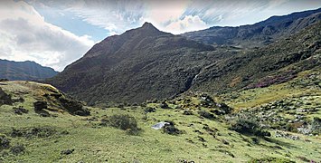
This plain ends abruptly where Troncal 5 passes, that is, in a line that goes from the town of Las Veguitas to Punta de Piedras, from which the Mérida mountain range begins, the final part of the Andean. The lowest and least rugged part of this part of the mountain range is the Sierra del Piedmonte, in which hills, small mountains, depressions and tables predominate. The highest and most rugged part is that of the Nevada, Tapo-Caparo and Calderas sierras, the first having peaks close to 4,000 m s. no. m. within Barinas, and counting the latter with a large number of valleys. The tables of Moromoy, El Curay and Parángula are landmarks that separate the high and low parts. Two great passes are found, both to the north: the one of the valleys and the depression of the Santo Domingo river and the one of the valleys of the Boconó river.
In the Paleozoic, the Mérida mountain range was formed as an island. The sediments of this accumulated to its east and west, giving way to the formation of the Llanos, around the Mesozoic.
The most important geological formations in the state are Palmarito, Caparo, with fossiliferous slates, and Sabaneta, with sandstones.
Hydrography and climate
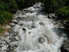
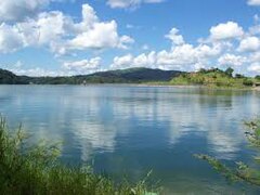
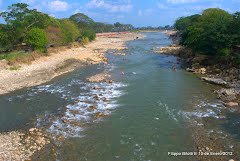
Barinas is characterized by having abundant rivers, so many that its capital is considered "capital of the rivers of Venezuela". the majority, brief upper and middle courses and flooding the Llanos Bajos in the rainy periods. The tributaries of the Apure River in Barinas are the Portuguesa, Masparro, Santo Domingo, Caparo, Canaguá and Uribante rivers, all of which are navigable. Some rivers that flow through the Piedmont give rise to depressions around them. There are also three reservoirs in the state: those of the Boconó, Masparro and Caparo rivers.
- Rivers and reservoirs
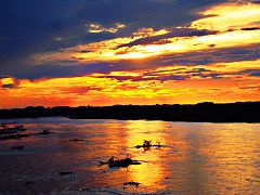
Rio Apure

Río Caparo and its reservoir

Río Santo Domingo
Blue River

Boconó River reservoir

Uribante River

Río Canaguá
Río Masparro
Rio Pagüey

Portuguesa River


._Guanare._Portuguesa.JPG)


Being in the intertropical zone and extending more towards the meridians than towards the parallels, Barinas has a climate determined by altitude, winds and two seasons: the dry season, from October to March, and the rainy season, from April to September. Of these factors, altitude is the one that modifies temperatures most forcefully. The cold winds that flow from the east of the Mérida mountain range to the Llanos Altos cause the characteristic phenomenon of the Barinese wind. According to Köppen's classification, the Sierra del Tapo-Caparo and the Llanos have a savannah climate (Aw), the Piedmont and Alto Apure, one monsoonal (Am), the Sierra Nevada and Calderas, one humid mountain (Cfbi), and the highest parts of these last two sierras, one tropical alpine (ETH).
- Bioclimatic landscapes
Paraamo, Sierra Nevada
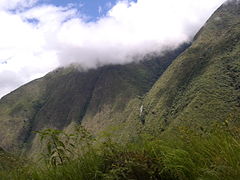
Tropical mountain forest, Santo Domingo valleys

Tree savannah, Piedemonte

Sabana, Llanos

Humedal, Low Plains

Estero, Netherlands


Flora and fauna
Barinas has two ecoregions: the Llanos and the Northern Andes, the latter being its center of endemism.
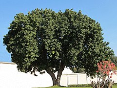
The Llanos are extensive grasslands and abundant gallery forests. In its flora, trees abound, among which the apamate, the jabillo, the saman, the ceibas, the mangoes, the merecure, the cañafistola llanera and the araguaney, the national tree; Palms also abound, especially the llanera. Among the herbs, the water lily and mother-of-pearl and barina flowers stand out.
On the contrary, the Mérida mountain range has, from its highlands to its foothills, páramos, tropical mountain forests, and wooded savannahs. Among its vegetation, cardón, cují, bucare and frailejones are characteristic in its upper parts, while linnet, granadilla, mahogany and vera abound in the foothills.
- Flora

Mango

Ceiba

Araguaney

Cañafístola llanera

Take it easy.
Water lily
Mother of pearl

Pardillo

Granadilla
Caoba

Vera

Cardón

Bucare
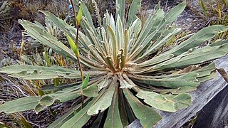
Frailejón


.jpg)


_-_Flickr_-_Alejandro_Bayer.jpg)
_-_Flickr_-_Alejandro_Bayer_(1).jpg)
.JPG)


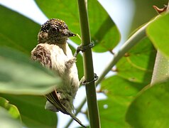
There are more than 450 species of birds, including those of prey —especially the Andean condor—, herons, storks, ducks, the paraulata, the Orinoco woodpecker and the carrao.
Mammals are the most abundant vertebrates, standing out the deer, foxes, otters, the anteater and honeycreeper, the cachicamo, the cunaguaro, the jaguar, the howler monkey and the capuchin, the rabipelado and, above all, everything, the capybara. Rabbits, spectacled bears, porcupines, and shrews are found only in the Andes.
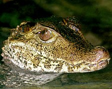
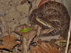
In the Llanos there is an abundance of reptiles, standing out the anacondas, the podocnemídidos, the iguanas, the rattlesnakes, the babo, the tortoise, the mato real, the Orinoco caiman and the mapanare.
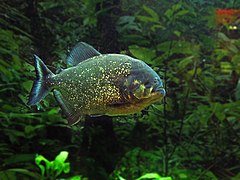
Fish populate all the rivers, with catfish, piranhas, goldfish, and electric eels being abundant in the Llanos, and trout in the Andes.
There are also two species in danger of extinction: the sabanero morrocoy and the tonina.
- Fauna

Chigüire
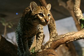
Cunaguaro
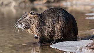
Nutria

Morrocoy sabanero

Tonina

Frontino bear

Iguana
Babo
Mapnare

Andean Condor
Carpenter

Trucha
Pirana
_(8578160737).jpg)

_in_a_partially_frozen_river_Ljubljanica.jpg)


_-_Flickr_-_Alejandro_Bayer_(2).jpg)

.jpg)
Demographics
In the State of Barinas the rural population had traditionally predominated, estimating that in 1950 the rural population corresponded to 84.8% of the total population of Barinas. The population of the state of Barinas, in the 1990 Census was 424,491 inhabitants. The estimated population for the year 2015 is 901,129 inhabitants.
Population Growth
| Year of the Census | Nro de Habitantes |
|---|---|
| 1873 | 49 448 |
| 1881 | 56 765 |
| 1891 | 62 696 |
| 1920 | 55 055 |
| 1950 | 85 944 |
| 1961 | 169 271 |
| 1971 | 231 046 |
| 1981 | 326 166 |
| 1990 | 424 491 |
| 2001 | 624 508 |
| 2011 | 854 391 |
| 2015 | 980 490 |
- Colombian Community in Barinas State:
Currently the state in general has the second largest Colombian community in Venezuela after the state of Táchira. with more than 300,000 people. They are grouped in the different and main cities of the entity, being the city of Barinas the one with the most presence. This immigration that has been in this region for more than 40 years is mainly due to the internal problems of the neighboring country, such as violence and the strong economic measures implemented there. But it should be noted that thanks to this the economy of the State has grown, establishing new forms of commerce and work in the fields, it can be said that today both Barineses and Colombians have compacted 100%.
- Distribution of the Colombian population in the State of Barinas:
- Barinas (Capital)-162,456 people
- Santa Barbara - 87,000
- Socopo - 42,000
- Pedraza - 22,000
- Barinitas - 15,000
- University of Los Andes, Economic and Social Research Institute
Population by Age Group (%)
| Population by Age Group (%) | |||||
|---|---|---|---|---|---|
| 0 - 14 years | 15 - 64 years | 65 and over | 0 - 14 years | 15 - 64 years | 65 and over |
| Census 2001 | Census 2011 | ||||
| 42.7 | 53.8 | 3.5 | 29.9 | 65.3 | 4.8 |
- United Nations Population Fund
- National Statistics Institute (INE) 2011 -
Population and Housing, by municipality
| Population | Housing | |||||||
|---|---|---|---|---|---|---|---|---|
| Municipality | Census 2001 | Census 2011 | Growth Annual rate Geometric (%) | Growth Relative (%) | Total | % | ||
| Total | % | Total | % | |||||
| Total | 624.508 | 100,00 | 816.264 | 100,00 | 3.6 | 47.1 | 211.793 | 100,00 |
| Alberto Arvelo Torrealba | 32.183 | 5.2 | 41.232 | 5,0 | 2.1 | 25.4 | 10.323 | 4.9 |
| Andrés Eloy Blanco | 15.359 | 2.45 | 16.144 | 2.0 | 8.1 | 135.1 | 4.796 | 2.2 |
| Antonio José de Sucre | 62.002 | 9.9 | 81.665 | 10,0 | 5.6 | 82.5 | 21.331 | 10,0 |
| Arismendi | 18.338 | 2.9 | 23.727 | 2.9 | 0.6 | 6.6 | 7.049 | 3.3 |
| Barrels | 263.272 | 42.2 | 353.851 | 43.4 | 3.7 | 49.3 | 89.592 | 42.3 |
| Bolívar | 39.779 | 6.4 | 52.872 | 6.5 | 2.0 | 24.4 | 14.447 | 6.8 |
| Cruz Paredes | 20.574 | 3.3 | 26.042 | 3.2 | 3.6 | 47.8 | 6.632 | 3.1 |
| Ezequiel Zamora | 42.104 | 6.7 | 53.580 | 6.6 | 2.8 | 36.3 | 14.446 | 6.8 |
| Bishops | 25.774 | 4,1 | 37.493 | 4.6 | 3,8 | 51.4 | 10.331 | 4.9 |
| Pedraza | 50.767 | 8.1 | 65.390 | 8,0 | 3.7 | 49,0 | 16.667 | 7.9 |
| Reds | 33.105 | 5.3 | 40.126 | 4.9 | 2.6 | 32.1 | 10.051 | 4.7 |
| Sosa | 21.251 | 3.4 | 24.142 | 2.9 | 5.4 | 79.1 | 6.128 | 2.9 |
- National Statistics Institute (INE), Censo 2001.
- National Statistics Institute (INE), Censo 2011.
Economy
Mineral Resources
The mining potential is expressed by non-metallic minerals such as: limestone, sand, silicate, quartz, red clay, feldspar, gravel, silica sand and phosphorite. Regarding energy resources, there are hydrocarbon reserves in the southern area of San Silvestre, where PDVSA operates several oil fields. Repsol YPF obtained in 2001 the award of the Barrancas block for the production of 2 million cubic meters of free gas per day. The gas is fed to the Termobarrancas power plant, in the Obispos municipality, with a generating capacity of 450 megawatts.

Tourism

Barinas has a contrast between landscapes of mountains, plains, rivers and streams, it offers tourists a variety of options, from contemplating rare species in their habitat, to enjoying its spectacular parks and natural spas.
From the city of Barinas to the state of Mérida passing through the municipality of Bolívar, which covers the towns of Barinitas, Altamira de Cáceres and Calderas, with a pleasant climate, characteristic of the humid tropical forest.
Barinitas, the capital of the municipality, has the Parque Moromoy where camping is done, the Balneario La Barinesa with recreational facilities and towards the southeast the Sector El Cacao, where mountain biking is practiced. There is also the boulevard of Plaza Bolívar and the Iglesia San Pedro. The route that leads to Altamira de Cáceres is used for bird watching due to the diversity of species, especially the Cock of the Rock.
Altamira de Cáceres is the first seat (1577) of what is now the city of Barinas. It still retains its colonial architecture, with its historic red-roofed houses.
Plaza Bolívar was turned into a boulevard and in its surroundings is the Church, the Casa de la Cultura Alfredo Arvelo Larriva, inns, restaurants, wineries, bakeries, Creole sweet shops and local crafts.
At a distance of 20 minutes following this mountain route towards the town of Calderas (founded in 1628), is the sugar mill "Los Castillos", near the farmhouse "La Bellaca", where the traditional process of making panela is carried out, produced by the locals since ancient times.
Upon arriving in Calderas you can visit natural places with recreational facilities, such as the "La Piedra del Patio" spa, on the banks of the Río Azul or Calderas. You can visit the house of culture Avelino Moreno and the "Centro de Enseñanza para el Desarrollo Rural" (TURN ON).
The route that starts from the city of Barinas to the Portuguesa State, highlighting on this route two important reservoirs, such as the Manuel Palacio Fajardo (Masparro) located 15 minutes from the town of Barrancas and Juan Antonio Rodríguez Domínguez (Boconó - Tucupido) located on the border with the Portuguesa State, where boat rides, kayaking and jet skiing, bird watching, and controlled sport fishing are carried out. In the town of "Obispos" (founded in 1713) the crops of musáseas, corn, cotton, sorghum, forest products predominate, in addition to livestock and oil exploitation.
Its colonial temple of San Nicolás de Bari was built in the XVIII century) and there are also popular expressions such as the joropo, corrío, couplets, tunes, bullfights and patron saint festivities.
The towns of Mijagual, Santa Rosa, Libertad, Dolores, Ciudad de Nutrias and finally Puerto de Nutrias, on the border with Apure State, are found along the road that leads to trunk 5, from Puente Páez, via Sabaneta. Large-scale crops can be observed in the fields of oilseed, cereals, sugar cane, tomato, cassava and fruit trees, as well as it is a livestock area.
In Sabaneta, culturally Dancing Devils of San Hipólito stands out, and musically there are the celebrations of the Bandola Festival in the town of Dolores (December), the Festival of Libertad and La Paz (January) and the elaboration of typical musical instruments in the town of Libertad.
35 kilometers from Barinas via Torunos you reach the town of El Real. In the month of January and at various times of the year, the inhabitants of this area and pilgrims from various parts of the world venerate the image of Nuestra Señora del Rosario del Real, which appeared in the middle of the century XVII.
Passing the bridge over the Paguey River is the town of San Silvestre, which in December celebrates its patron saint festivities in honor of San Silvestre, where the Coleados Bulls constitute one of the most touristic shows in the town.
Another site of interest is the Sierra Nevada National Park located between the states of Mérida and Barinas. It is a protected ecosystem that has forests, moors, xeric scrub and the highest altitudes in the country, such as Pico Bolívar with 5,007 meters above sea level, the Humboldt peaks 4,920 m above sea level. no. m. and Bompland 4942 m s. no. m., La Concha 4920 m s. no. m., El Toro 4755 m a.s.l. no. m. and El León 4740 m a.s.l. no. m..
The Municipal Spa and the Río Boconó Spa located on the banks of the Cipe River, in the Obispos municipality and in the Alberto Arvelo Torrealba municipality, respectively, are natural spas surrounded by leafy trees.
In the surroundings of Peña Viva there is a vast network of pre-Columbian petroglyphs that constitutes the richest and most complete sample collection currently known in Venezuela.
Barinas has a botanical garden located within the Ezequiel Zamora National Experimental University of Los Llanos.

Natural heritage
- Municipal spa
- Balneario Río Boconó.
- Canagua
 Bridge of Bruzual
 - Cerro el Gobernador
- Cave the Devils
- Cave the Corridors
- Botanical Garden of the Unellez
- The Acequia
- The Patio Stone
- La Yuca Parque
- La Carolina
- Parque Los Samanes
- Moromoy Park
- Sierra Nevada National Park
- Tapo-Caparo National Park
- Fauna Reserve
- Sabana de Anaro
- Río Masparro
- Rio Pagüey
- Río Santo Domingo
- Rio La Yuca

Cultural heritage
- House of Culture
- Casa del Poeta Lazo Martí
- Centro Cultural Alfredo Arvelo Larriva
- Virgin of the Real
- The Calvary Embalse Manuel
- Baroque Church San Nicolás de Bari de Bishops
- Immaculate Conception Church
- Alberto Arvelo Torrealba Museum
- Palace El Marqués
- Municipal Workshop of Art Rafael Calvo
Sports
The state of Barinas has a First Division soccer club, called Zamora Fútbol Club, founded on February 2, 1977, and the stadium in which they reside is the La Carolina Stadium, it is also one of the stadiums used for the Copa América 2007, held in Venezuela.
Likewise, in 2007, Barinas hosted the second leg of the Copa Nissan Sudamericana between Zamora FC and Olmedo from Ecuador, which the visiting team won 2 goals to 1. This was Zamora FC's first international match. Subsequently, it hosted three Copa Sudamericana matches and three editions of the Copa Libertadores.
In 2011 the Zamora Fútbol Club was proclaimed champion of the Clausura Championship and runner-up in Venezuela. And by the middle of 2013, he won the Clausura Championship for the second time, and was champion of the Venezuelan Professional Soccer Tournament against Deportivo Anzoategui. In 2013 the Zamora Fútbol Club won its first absolute championship, after being proclaimed champions of the 2013 Clausura Tournament, in May 2014 it won its absolute Bicampeonato vs Mineros de Guayana, and in December 2016 it achieved its third star (absolute championship) in 5 years after being crowned champion in the Apertura Tournament vs. Deportivo Anzoátegui and winning the Absolute Final vs. Zulia FC.
The Varyna Sport Volleyball Club of the national professional volleyball league in Venezuela was also created in 2011.
In Baseball, the Petroleros de Barinas Team is established, which plays in the Venezuelan national parallel League, where it has been proclaimed Champion twice.
Transportation
The state road network is the main means of communication both internally and with the rest of the country. This road has 7,094.5 kilometers of trunk roads, of which only 15% are paved, so it is advisable to travel in all-terrain vehicles. Trunk 5 is the most important road axis and connects Barinas with the states of Portuguesa and Táchira and Apure.
The city of Barinas has the Luisa Cáceres de Arismendi Airport, located on Agustín Codazzi Avenue.
The city also has a passenger terminal.
Featured Characters
Contenido relacionado
Armorers
Tormes Beacon
Anvil rack