Baltic Sea
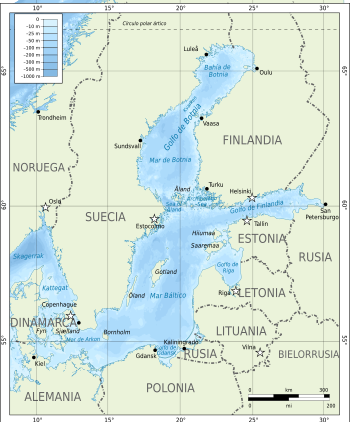
The Baltic (from Latin Mare Balticum) is a brackish water inland sea north of Europe, open to the North Sea and, finally, to the Atlantic Ocean at through the Kattegat and Skagerrak straits. The countries that surround it are (starting with the Scandinavian peninsula and continuing clockwise): Sweden, Finland, Russia, Estonia, Latvia, Lithuania, Poland, Germany and Denmark.
Its area is 432,800 km² and includes two large gulfs: the Gulf of Finland, between the south of this country and Estonia, and the Gulf of Bothnia, between the eastern coast of Sweden and the western coast of Finland. Geologically it is very young: it has only existed since the 6th millennium BC. It is very shallow (average 57 meters; maximum depth is 459 meters to the north of the Swedish island of Gotland), which, together with the little opening to the ocean, makes the renewal of the waters very slow and favors pollution problems. The tides are of very small amplitude.
The Baltic is also the largest amber deposit in the world and, furthermore, its quality is one of the best: of the twenty amber deposits in the world, it is said that the Baltic one is only surpassed by those of Mexico and the Dominican Republic, being the one that produces the most coniferous amber and the best quality. 500 to 800 million tons of amber are extracted from it.
The basin that drains the Baltic encompasses the entirety of some riparian countries such as the Baltic republics, Poland, and the Kaliningrad region of Russia. In addition, these rivers are born in, or cross territories belonging to other countries that, despite not having coasts, communicate with the sea by fluvial route. Such is the case of the Czech Republic, Slovakia, Ukraine and Belarus, which end up contributing water (indirectly) to the Baltic.
Etymology
Name in other languages
The Baltic receives different names depending on the language:
- Baltic Sea It is the usual form in Romanesque languages, Slavs (Polish, Russian, Casubian), Baltic and English. So:
- Bôłt (casubian).
- Baltijas jūra (leton).
- jūra shoes (Lithuanian).
- Morze Bałtyckie or Bałtyk (polka).
- Smoking, Baltískoie More (Russian).
- East Sea is as it is called in all Germanic languages except English, in addition to Finnish (as though its speakers are mostly west of the sea, they were under Swedish dominion for many centuries, and from the Swedish perspective the sea is left to the east). So:
- Ostsee (German).
- Østersøen (danese).
- Itämeri (ends).
- Östersjön (Swedish).
- West Sea is the name given in Estonia:
- Länemeri (Estonian).
History
In Roman times, the Baltic was known as the Mare Suebicum or Mare Sarmaticum. Tacitus described the Mare Suebicum, named after the Suevi (Suebi). The Suevi eventually migrated southwest to reside for a time in the Rhineland area of modern Germany, where their name survives in the historical region known as Swabia. Jordanes called it the "Germanic Sea" in his work, the Getica.
Since Viking times, Scandinavians have called it Austmarr ("East Lake"). The "East Sea" appears in the Heimskringla, and Eystra salt in the Sörla þáttr. Saxon Grammarian records in Gesta Danorum an older name, “Gandvik”; the Old Norse suffix -vik (for bay) implies that the Vikings correctly regarded it as an inlet from the sea.
At the beginning of the 11th century, the southern and eastern shores of the Baltic were settled by migrants mainly from Germany, a movement called the Ostsiedlung ("Eastern Settlement"). Other settlers were from the Netherlands, Denmark, and Scotland. The Polabian Slavs were gradually assimilated by the Germans.Denmark gradually gained control over most of the Baltic coast, until it lost much of its belongings after being defeated at the Battle of Bornhöved in 1227.
In the 13th to 17th centuries, the strongest economic force in Northern Europe was the Hanseatic League, a federation of merchant cities from across the Baltic and North Seas. In the 16th and early 17th centuries, Poland, Denmark, and Sweden fought wars for Dominium Maris Baltici ("Lordship over the Baltic Sea"). In time, it was Sweden, which practically encompassed the entire Baltic coast. In Sweden they referred to the sea as Mare Nostrum Balticum ("Our Baltic Sea").
Trade routes along the sea were key to the European economy. The Dutch who dominated the Baltic trade in the 17th century, with a strong English influence in the more modern stage. The Danes sustained their economy in the Modern Age in the tolls on the Sund that were charged for accessing the sea, their revocation being an objective of the Dutch, British, Swedish and Russian. Access to non-seasonal ports was one of the development priorities of the Russian empire, which established itself as a regional power after the Great War in the North.
Geography
Subdivisions
The northern part of the Baltic is known as the Gulf of Bothnia, of which the northernmost part is the Bothnian Bay. The more rounded southern basin of the gulf is called the Bothnian Sea and immediately to the south of this is the Åland Sea. The Gulf of Finland connects the Baltic Sea with Saint Petersburg. The Gulf of Riga lies between the city of Riga, the capital of Latvia, and the Estonian island of Saaremaa.
The Northern Baltic lies between the Stockholm area, southwestern Finland and Estonia. Gotland's western and eastern basins form the main parts of the Central Baltic, or the Baltic proper. The Bornholm Basin is the area to the east of Bornholm, and the shallowest part of the Arkona Basin that extends from Bornholm to the Danish islands of Falster and Zealand.
In the south, the Gdańsk Bay lies east of the Hel Peninsula on the Polish coast and west of the Sambia Peninsula in Kaliningrad Oblast. The Pomeranian Bay is located north of the islands of Usedom and Wolin, east of Rügen. Between Falster and the German coast lie the Bay of Mecklenburg and the Bay of Lübeck. The westernmost part of the Baltic is the Bay of Kiel. The three Danish straits, the Great Belt, the Little Belt and the Sound (or Oresund), connect the Baltic with Kattegat Bay and the Skagerrak Strait in the North Sea.
Sea Ice
As an annual average, the Baltic Sea is covered with ice on a maximum of 45% of its surface. The ice-covered area during a typical winter includes the Gulf of Bothnia, the Gulf of Finland, the Gulf of Riga, Väinameri in the Estonian Archipelago, the Stockholm Archipelago, and the Archipelago Sea of Finnish territorial waters. The rest of the Baltic does not freeze over during a normal winter, with the exception of sheltered bays and shallow lagoons such as the Curonian Lagoon. The ice reaches its maximum degree in February or March; typical ice thickness in the northernmost areas of Bothnian Bay, the northern basin of the Gulf of Bothnia, is about 70 cm (28 in) for Landfast sea ice. The thickness decreases towards the south.
Freezing begins in the northern reaches of the Gulf of Bothnia typically in mid-November, reaching the open waters of the Bothnian Bay in early January. The Bothnian Sea, the southern Kvarken basin, freezes over, on average, at the end of February. The Gulf of Finland and the Gulf of Riga usually freeze over at the end of January. In 2011, the Gulf of Finland was completely frozen on February 15.
The extent of the ice depends on whether the winter is mild, moderate, or severe. Severe winters can lead to ice formation across southern Sweden, and even in the Danish Straits. According to 18th century lowercase natural historian William Derham, during the bitter winters of 1703 and 1708, the ice cap it extended as far as the Danish Straits. Often parts of the Gulf of Bothnia and the Gulf of Finland are frozen, and along the coastline in places further south such as the Gulf of Riga. This description claims that the whole of the Baltic was covered with ice.
In the last few years before 2011, the Bothnian Bay and the Bothnian Sea froze over with solid ice near the Baltic coast and floating ice from there. In 2008, there was almost no ice formation except for a brief period in March.
During spring, the Gulf of Finland and the Gulf of Bothnia usually thaw in late April, with some ridges of ice persisting until May at the eastern ends of the Gulf of Finland. In the northernmost part of the Bothnian Bay, the ice usually remains until the end of May; at the beginning of June it is practically nil.
Hydrography
The Baltic flows through the Danish Straits; however, the flow is complex. A surface layer of brackish water discharges 940 km³ per year into the North Sea. Due to the difference in salinity, by salinity permeation principle, a sub-surface layer of more saline water moving in the opposite direction brings 475 km³ per year. It mixes very slowly with upper water, resulting in a salinity gradient from top to bottom, with most of the remaining saline water below 40 to 70 m depth. The general circulation is to the left: north along its eastern border, and south along its western one.
The difference between the output and input comes entirely from fresh water. More than 250 rivers drain a basin of approximately 1.6 million square kilometers, contributing a volume of 660 km³ per year to the Baltic. They include the major rivers of northern Europe, such as the Oder, the Vistula, the Niemen, the Daugava, and the Neva. The additional fresh water comes from the difference in precipitation minus evaporation, which is positive.
Salinity
The salinity of the Baltic is very low compared to that of other seas or oceans; It can be considered intermediate between fresh and salt water. This fact is explained by its high latitude (it experiences little evaporation), combined with a large contribution of fresh water from many rivers which, due to the already mentioned narrowness of their communication with the ocean, are very difficult to evacuate and renew with saltwater. This low salinity has strong biological implications, with many species different from their counterparts in other seas.
The more saline water is vertically stratified in the northern water column, creating a barrier to oxygen and nutrient exchange, and fostering completely separate marine environments.
Main tributaries of the Baltic
| Name | Average download | Length | Cuenca | States sharing the basin | Longer water course |
| Neva | 2500 m3/s | 74 km (nominal) 860 km (hydrological) | 281 000 km2 | Russia, Finland | Suna (280 km) → Lake Onega (160 km) → Svir (224 km) → Ladoga Lake (122 km) → Newa |
| Vistula | 1080 m3/s | 1047 km | 194 424 km2 | Poland, Belarus, Ukraine, Slovakia | |
| Dvina | 678 m3/s | 1020 km | 87 900 km2 | Russia, Latvia | |
| Neman | 678 m3/s | 937 km | 98 200 km2 | Belarus, Lithuania, Russia | |
| Kemi River | 556 m3/s | 550 km | 51 127.3 km2 | Finland, Norway | greater tributary Kitinen |
| Oder | 540 m3/s | 866 km | 118 861 km2 | Czech Republic, Poland, Germany | |
| Rio Lule | 506 m3/s | 461 km | 25 240 km2 | Sweden | |
| Narva | 415 m3/s | 77 km (nominal) 652 km (hydrologic) | 56 200 km2 | Russia, Estonia | Velikaya (430 km) → Lake Peipus (145 km) → Narva |
| Torne älv | 388 m3/s | 520 km (nominal) 630 km (hydroloic) | 40 131.4 km2 | Norway, Sweden, Finland | Válfojohka → Kamajåkka → Abiskojaure → Abiskojokk (sumu = 40 km)→ Torneträsk (70 km) → Torne älv |
Islands and Archipelagos
- Åland Islands (Finland)
- Sea of the Archipelago (Finland)
- Pargas
- Nagu
- Korpo
- Houtskär
- Kustavi
- Kimito
- Blekinge Archipelago (Sweden)
- Bornholm (Denmark)
- Falster (Denmark)
- Gotland (Sweden)
- Hailuoto (Finland)
- Kotlin (Russia)
- Lolland (Denmark)
- Kvarken (Finland)
- Møn (Denmark)
- Öland (Sweden)
- Rügen (Germany)
- Stockholm Archipelago (Sweden)
- Värmdön (Sweden)
- Usedom or Uznam (divided between Germany and Poland)
- Moonsund Archipelago (Estonia):
- Hiiuma
- Muhu
- Saaremaa
- Vormsi
- Wolin (Poland)
- Zealand (Denmark)
Coastal countries
Countries with sea coasts:
![]() Denmark,
Denmark, ![]() Estonia,
Estonia, ![]() Finland,
Finland, ![]() Germany,
Germany, ![]() Latvia,
Latvia, ![]() Lithuania,
Lithuania, ![]() Poland,
Poland, ![]() Russia,
Russia, ![]() Sweden.
Sweden.
Countries that are in the drainage basin, but do not have coastlines to the sea:
![]() Belarus,
Belarus, ![]() Czech Republic,
Czech Republic, ![]() Norway,
Norway, ![]() Slovakia,
Slovakia, ![]() Ukraine.
Ukraine.
The drainage basin of the Baltic Sea is about four times the surface area of the sea itself. About 48% of the region is forested, with Sweden and Finland containing the most forest, especially around the Gulfs of Bothnia and Finland.
About 20% of the land is used for agriculture and grazing, mostly in Poland and the edge of the Baltic in Germany, Denmark and Sweden. About 17% of the watershed is unused open land and another 8% wetlands. Most of the latter are in the Gulfs of Bothnia and Finland.
Coastal cities
Geology
The Baltic is rather like a riverbed, with two tributaries, the Gulf of Finland and the Gulf of Bothnia. Geological surveys show that before the Pleistocene instead of the Baltic, there was a wide plain around a large river paleontologists call it the Eridans. Several episodes of glaciation during the Pleistocene removed the river bed into the sea basin. By the time of the last, or Eemian stage, the Eemian Sea was in place. Instead of a true sea, the Baltic can even today also be understood as the common estuary of all the rivers that flow into it.
Biology
About 100,000 square kilometers (38,610 square miles) of the Baltic seafloor (a quarter of its total area) is a dead zone variable. The more saline (and therefore denser) the water remains at the bottom, isolating it from surface waters and the atmosphere. This leads to a decrease in oxygen concentrations in the area. It is mainly bacteria growing in it, digesting organic matter and releasing hydrogen sulfide. Because of this large anaerobic zone, the ecology of the seafloor differs from that of the Atlantic.
Plans to artificially oxygenate areas of the Baltic that have experienced eutrophication have been proposed by the University of Gothenburg and InOcean AB. The proposal intends to use wind-driven pumps to inject oxygen (air) into waters at or around 130 m below sea level.
The fish fauna of the Baltic is a mix of marine species such as cod, herring, hake, plaice, sole, scorpionfish and turbot, and freshwater species such as perch, pike and crayfish. white.
Satellite images taken in July 2010 revealed a massive algae bloom covering 377,000 square kilometers (146,000 square miles) in the Baltic. The flowering area extends from Germany and Poland to Finland. Researchers of the phenomenon have indicated that algal blooms have occurred every summer for decades. Fertilizer runoff from surrounding farmland has exacerbated the problem and led to increased eutrophication.
Economy
The construction of the Great Belt Bridge in Denmark (completed 1997) and the Øresund Bridge-Tunnel (completed 1999), linking Denmark with Sweden, created a road and rail connection between Sweden and mainland Denmark (the Jutland peninsula). The Øresund Underwater Tunnel allows large ships to navigate freely to and from the Baltic.
The Baltic is the main trade route for the export of Russian oil. Many of the neighboring Baltic countries have been concerned about this, as an oil leak in an ocean-going tanker would be disastrous for the Baltic, due to the slow exchange of water. The tourist industry surrounding the Baltic is naturally concerned about oil pollution.
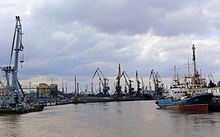
Much shipbuilding takes place in shipyards throughout the Baltic. The largest shipyards are in Gdańsk, Gdynia and Szczecin, Poland, Kiel, Germany, Karlskrona, Malmö, Sweden; Rauma, Turku and Helsinki, Finland; Riga Ventspils and Liepaja, Latvia; Klaipeda, Lithuania; and Saint Petersburg, Russia. There are several cargo and passenger ferries operating in the Baltic.
Tourism
Springs
- Liepaja, Latvia
- Sopot, Poland
- Międzyzdroje, Poland
- Kołobrzeg, Poland
- Klaipėda, Lithuania
- Heiligendamm, Germany
Tourist destinations
- Świnoujście, Poland
- Kamień Pomorski, Poland
- Kołobrzeg, Poland
- Pärnu, Estonia
- Jūrmala, Latvia
- Palanga, Lithuania
- Nida, Lithuania
- Sopot, Poland
- Ueckermünde, Germany
- Ustka, Poland
- Svetlogorsk, Russia
Helsinki Convention
1974 Agreement
For the first time in history, all sources of pollution in an entire sea are subject to a single convention, signed in 1974 by the then seven countries bordering the Baltic. The 1974 Convention entered into force on May 3, 1980.
1992 Convention
In light of the changes and evolution of international maritime and environmental law, a new convention was signed in 1992 by all the Baltic States and the European Community. After ratification, the convention entered into force on January 17, 2000. The convention covers the whole of the Baltic area, including inland waters and the waters of the sea itself, as well as the seabed. Measures are also taken throughout the Baltic basin to reduce land-based pollution. The Convention on the Protection of the Marine Environment of the Baltic Sea Area of 1992, entered into force on January 17, 2000.
The governing body of the Convention is the Helsinki Commission, also known as HELCOM, or the Baltic Marine Environment Protection Commission. The present contracting parties are Denmark, Estonia, the European Community, Finland, Germany, Latvia, Lithuania, Poland, Russia and Sweden.
The instruments of ratification were deposited by the European Community, Germany, Latvia and Sweden in 1994, by Estonia and Finland in 1995, Denmark in 1996, by Lithuania in 1997 and by Poland and Russia in November 1999.
Contenido relacionado
Stone Fountain Lagoon
PRD
Salvatierra Berrocal


