
Atacama Desert
The Atacama Desert is the «driest non-polar place on Earth». It spans the natural regions of the Norte Grande and Norte Chico of Chile, covering the regions of Arica and Parinacota, Tarapacá, Antofagasta, Atacama and the north of the Coquimbo region. It covers an approximate area of 105,000 km², and has a length of almost 1,600 km and a maximum width of 180 km. It is bounded by the Pacific Ocean to the west and by the Andes mountain range to the east.
According to the World Wide Fund for Nature, the Atacama Desert ecoregion extends from Arica (18°24'S) to near La Serena (29°55'S). the National Geographic Society considers the Peruvian coastal zone to be part of the Atacama Desert.
Another integral part of this desert corresponds to an ecoregion called puna de Atacama, located above 3500 m a.s.l. no. m. and that it is shared by the western slope of the Andes mountain range in the north of Chile, and by the eastern slope of the same in the northwest of Argentina and southwest of Bolivia.
This Chilean ecoregion is rich in metallic mineral resources —such as copper (Chile is the world's largest producer and has 28% of world reserves), iron, gold and silver— and non-metallic —among which which include important deposits of boron, lithium (Chile has 39% of South American reserves), sodium nitrate and potassium salts—. Also noteworthy is bischofita, a magnesium salt extracted from the Atacama salt flat, used as a caking agent in road construction. These resources are exploited by several mining companies, such as Codelco, the largest copper company on the planet, Lomas Bayas, Mantos Blancos and Soquimich. It is the "place with the highest solar radiation on the planet", exceeding seven kilowatt hours per square meter, therefore, the "place with the greatest solar energy potential on the planet".
Origin
Its origin dates from about three million years ago, being in its past a seabed. The main cause of its origin is a climatic phenomenon known as the Föhn effect, produced on the eastern slopes of the Andes mountain range. This causes the clouds to dump their precipitation on only one face of the mountain in their vertical ascent; When crossing the mountain range, the clouds do not have water, thus generating a desert by completely blocking all possible precipitation from the east. Precipitation is also blocked from the west by stable high-pressure systems, known as "Pacific highs," which stay close to the coast, creating easterly trade winds that move storms.
On the other hand, the Humboldt Current carries cold water from Antarctica northward along the Chilean and Peruvian coasts, which cools westerly sea breezes, reduces evaporation, and creates a thermal inversion—cold air immobilized under a layer of warm air—preventing the formation of large rain-producing clouds. All the moisture progressively created by these sea breezes condenses along the steep slopes of the Coastal Range that face the Pacific, creating highly endemic coastal ecosystems made up of cacti, succulents, and other specimens of xerophytic flora.
The last factor contributing to the formation of the desert is the Andes mountain range, which in the north forms a wide, elevated volcanic plain known as the Altiplano. Just as in the south the Andean mountain range helps capture moisture from the Pacific, in the north the Altiplano prevents moisture-laden storms from the Amazon basin to the northeast from entering Chile.
Climate


In the Atacama desert, a measurable rain —that is, 1 mm or more— can take place once every 15 or 40 years — periods of up to 400 years without rain have been recorded in its central sector. However, the area is affected between January and February by the so-called "highland winter", which produces occasional rain and abundant electrical storms.
Contrary to conventional wisdom, it is not the most arid desert in the world, with the name corresponding to the McMurdo Dry Valleys.
At night the temperature fluctuates a lot, as it can drop to -25 °C in the Ollagüe area, while during the day the temperature can be between 25 and 50 °C in the shade. There is not much difference between summer and winter, because it is located on the edge of the Tropic of Capricorn. In summer, the morning room temperature is 4 to 10 °C and the maximum can reach 45 °C in full sunlight. Solar radiation is very high in the ultraviolet spectrum, so it is essential to use glasses and creams with UV protection.
The relative humidity of the air is barely 18% inland, but very high on the coast, reaching up to 98% in the winter months. The atmospheric pressure is 1017 millibars. There are seasons of winds in tornadoes or blizzards whose speed can easily reach 100 km/h, generally registered at noon.
Flora and fauna
Its flora and fauna are conditioned by aridity. The vegetation in this place, capable of surviving and adapting to its extreme climate, corresponds to different species of cacti. The orography of the desert territory produces small water holes in the area, that is, small pools of water that give rise to another type of vegetation. When the amount of water increases, species such as the emerald, the pica or the matilla sprout.
Regarding the fauna, there are some birds such as hummingbirds (cordillerano, Arica, cora, Puna, northern and giant, among others), turtle doves and doves (Bolivian, speckled wings, the Puna and quiguagua, among others). Dry riverbeds known as "desert rivers" also appear, providing habitat for various species. The fauna that can be found in these places are owls (chuncho del norte, lechuza, pequén, tucúquere), guanacos, vicuñas and foxes (chilla and culpeo), among others.
Due to the climatic and altitude conditions of this area, the fauna and flora are different from those of the neighboring territories. Despite the fact that the area is desert, it has lagoons, known as Chaxa, Meniques and Puriguatin, which constitute an important tourist center and ecological and natural attraction of this territory. They allow the growth of different flowers, such as the cachiyuyo, the llareta and the paja brava, among others. The Los Flamencos National Reserve is located in this area, one of the busiest tourist spots.
History

The Atacama Desert has been populated since the beginning of American colonization. A milestone for the first inhabitants of this area was mining, which began between 12,000 and 10,000 years ago in an iron oxide mine in Taltal, Antofagasta Region, the oldest on the continent. During the pre-Hispanic period, the Chinchorro culture stood out, developed between 5000 and 1700 BC. C., the first in the world to artificially mummify its dead. In addition, this territory was inhabited by ethnic groups such as the Atacameños, while the monkeys, the cabbages, the lupacas and the aurochs lived on its coast. It was dominated by the lordship of Chucuito under the name of Collesuyo and later by the Inca Empire as Collasuyo.
The most arid region was called «despoblado de Atacama» during the Colony. After the Spanish-American Wars of Independence, and due to the inaccuracy of the royal documents, the area was in dispute until, through the boundary treaties of 1866 and 1874, the region officially became Bolivian territory.
Despite the signed treaties, the disputes could not be resolved. On February 14, 1879, the Chilean landing in Antofagasta took place, initiating military actions against Bolivia. In 1873, the Peru-Bolivia Defensive Alliance treaty had been signed, so Chile declared war on both on April 5, 1879, formally starting the War of the Pacific, which ended in 1884 with the victory of Chile, the treaty of Ancón with Peru and the Truce pact with Bolivia. After the conflict, Chile obtained control of the until then Bolivian department of Litoral, the Peruvian department of Tarapacá and the Peruvian province of Arica, taking full control of the desert de Atacama that it previously shared with Bolivia and Peru.
Astronomy

The Atacama desert is considered the best place on the planet to observe the firmament and develop astronomy: its height with respect to sea level, the low cloudiness, the almost non-existent humidity of the air and the distant light and radioelectric pollution make that the visibility of your night sky is very clear. Due to this, more than a dozen observatories are located in this place —such as Paranal (VLT), the most advanced and powerful astronomical complex on the planet, ALMA, the largest astronomical project in the world, and La Silla, among others. others-. Chile has 40% of the world's astronomical observation; however, in the coming decades, the sector will develop other projects such as the Giant Magellan Telescope, the Large Synoptic Survey Telescope (LSST), the E-ELT and the expansion of the Atacama Large Millimeter Array— which will make the north of the country concentrate about 70% of the world total.
Sports
The Atacama Desert is home to all-terrain athletes from around the world. In this desert, the various championships of the Baja Atacama Rally, Baja Chile Rally, Patagonia Atacama Rally have been held, and it hosted the Dakar Series Rally —in 2009, 2010, 2011, 2012, 2013, 2014 and 2015—, an event organized by Amaury Sport Organization (ASO). The dunes of this desert are ideal for this type of sport, located in the outskirts of the city of Copiapó, Atacama Region.
Another event that takes place in this desert is the "Atacama Solar Race", which consists of a race of solar vehicles that takes place in places in the desert such as Toconao, Calama, Iquique and Antofagasta, among others.[ citation required]
Gallery

With 6739 msnm, the Llullaillaco Volcano is the highest altitude in the Atacama Desert.
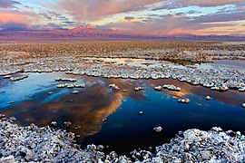
Salar de Atacama
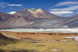
Salar de Talar and lagoon Miscanti, 4200 m above sea level

Rally Patagonia-Atacama 2007
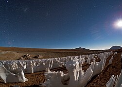
Ice creamed Penitents in the Moonlight in Chajnantor

The Valley of the Moon, near San Pedro de Atacama

Florid desert

The Atacama Giant

Laguna Roja

He'll play Copaquilla, near Putre

Morro de Arica, located in the city

Andean flamencos in the Salar de Atacama

Vicuñas in the Atacama Desert


.jpg)


Contenido relacionado
European Union
New Scotland
Chincha high