Aqua-Line Tokyo Bay

format_list_bulleted Contenido keyboard_arrow_down
ImprimirCitar

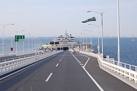
The Aqua-Line Tokyo Bay consists of an underwater tunnel that runs under Tokyo Bay and a bridge, linking Kawasaki, in Kanagawa prefecture, with Kisarazu, in the Chiba Prefecture, at the opposite end of Tokyo Bay.

The highway, also known by the name of CA, has a total length of 23.7 km and is where National Highway 409 runs (or connects to both ends of the bay), crossing the bay at Aqua- Tokyo Bay Line. 15.1 km correspond to the tunnel and bridge itself, approximately 2/3 are from the underwater tunnel and 1/3 are from the bridge. Its construction cost 11,077 million dollars. It was inaugurated on December 18, 1997. In 2004, the fee for a private vehicle was 3,000 yen, which was lowered to 2,000 yen at the end of March 2005.

View of Mount Fuji and the city of Yokohama from the Umihotaru

At the junction between the underwater tunnel and the bridge there is an artificial island called Umihotaru, which is a resting place (parking area) and lookout. From the Umohotaru, you can see Tokyo Bay and the cities that are on the shores of that bay, such as Tokyo, Yokohama, Kawasaki, Chiba, etc. Also on clear days and with good visibility, you can see Mount Fuji and Mount Tsukuba.

Aqua-Line Tokyo Bay also has another artificial island that is a vent for the underwater tunnel, and is known as the Wind Tower (風の塔 Kaze no tō).

The wind tower
Umihotaru
Image of the bridge, from the city of Kisarazu.

|

Aqua-Line Highway Video

Switchers and features

  • IC - Exchanger, SIC - Exchanger smart, JCT - Cross exchanger, PA - Park area, SA - Service area, BS - Bus stop, TN - Tunnel, BR - Bridge, TB - Toll.
N.o Dist. from
Origin
Name Connections BS Notes Location
1
IC/JCT
0.0 IC Ukishima
JCT Kawasaki Ukushima
Shuto Urban Expwy Sign B.svg Bayshore route
Shuto Urban Expwy Sign K6.svg K6 - Kawasaki Route (Autopista Shuto)
Japanese National Route Sign 0409.svg National Route 409
Kawasaki Kanagawa
TN Aqualine Tunnel Tokyo Bay
(purchasing strength cyclical)
tunnel length of 9.610 m
Prohibition of traffic in dangerous vehicles
Wind tower (MEDIATE Kaze no tō): Kawasaki artificial island at almost the midpoint of the tunnel
PA 9.8 Umihotaru Park Area
(Exploration)
O Sea-flooring (LINK LINK) Umihotaru: artificial island Kisarazu, it is possible to return to Kawasaki through the tunnel or follow through the bridge to Kisarasu Kisarazu Chiba
BR Aqualine Bridge Tokyo Bay
(purchasing cyclic)
Length approx. 4500 m bridge
2
TB/IC
15.1 Kisarazu toll (plus demonstrated
IC Kisarazu Kaneda (!
Japanese National Route Sign 0409.svg National Route 409
3
IC
19.0 IC Sodegaura Japanese National Route Sign 0409.svg National Route 409
Japanese National Route Sign 0410.svg National Route 410
Japanese National Route Sign 0016.svg National Route 16
O Sodegaura
-
JCT
22.2 JCT Kisarazu Nishi (plus whomever trainedJCT) Japanese National Route Sign 0409.svg National Route 409
Kisarazu
16
JCT
23.7 JCT Kisarazu
(Haiti)
Japanese National Route Sign 0409.svg National Route 409
E14 Tateyama Expressway
Japan expwy numbering C4.jpg Ken-ш Expressway (Metropolitan Inter-City Expressway)

Contenido relacionado

Diode

A diode is an electronic component with two terminals that allows electric current to flow through it in only one direction, blocking its passage if the...

Obsolescence

Obsolescence is the state of being that occurs when an object, service or practice is no longer maintained or required even though it is still in good working...

VR6 engine

The VR6 engine is an internal combustion engine whose arrangement consists of six cylinders at a narrower angle than usual. It was developed by Volkswagen in...
Más resultados...
Tamaño del texto:
Copiar