Angolan Geography
Angola is located on the Atlantic coast of Africa. It limits to the north with the Democratic Republic of the Congo, to the east with Zambia and to the south with Namibia. Separated from the rest of the national territory by the outlet to the sea of the Democratic Republic of the Congo, is the enclave of Cabinda, which is bordered to the north and east by the Republic of the Congo and to the south by the Democratic Republic of the Congo. The country is roughly in the shape of a square with 1,300 km of coastline. The total area is 1,246,700 square kilometers together with the enclave of Cabinda.
Relief
The country is made up of an arid coastline stretching from Namibia to Luanda, a humid inland plateau, dry savannah in the south and southeast, and jungle in the north and Cabinda. The Zambezi River and several tributaries of the Congo River have their sources in Angola. Two thirds of the country's surface is made up of a plateau with an altitude that varies between 450 and 600 meters. The coastal strip is tempered by the cold Benguela current, which results in a climate similar to that of the coast of Peru or Baja California. The coast is mostly flat, with occasional low cliffs of red sedimentary rock. There is a deep bay on the coast called Bahía de los Tigres. To the north lie Port Alexander, Little Fish Bay and Lobito Bay, while shallow bays are numerous. Lobito Bay has enough water to allow the unloading of large ships near the coast.
Coastal Plain
the coast of Angola, in the west of the country, is crossed by a narrow coastal strip whose width varies from 25 km around the city of Benguela, at the beginning of the southern third of the coast, to 150 km from width south of Luanda, at the beginning of the northern third of the coast, in the Cuanza river valley. The north-flowing cold Benguela Current makes the coast predominantly dry and scrub-covered in the central and northern sections. In the southern section, below Benguela, the climate is drier and the scrubland gives way to dunes. This region is the northern extension of the Namib Desert, which is, in turn, the coastal extension of the Kalahari Desert.
Mountains and central plateau
The coastal plain gives way to a series of scattered mountain ranges and hills that stretch across the western part of the country, parallel to the coast. The Cuanza River divides the mountainous region into a northern part with elevations between 500 and 1,800 m, and a southern part with elevations exceeding 2,400 m. The mountains stretch towards Namibia. Of note is the Serra da Chela, which rises 2,300 m from the coastal plain in the south of the country and is part of the South African Great Escarpment that separates the Namib coastal desert from the Huíla plateau. To the west it forms some remnant inselbergs of the plateau that was formerly more extensive. The 200-million-year-old Sierra de Chela was part of the supercontinent Pangea and is on the edge of the plates that broke apart to form America.
To the east and center of the country is an area of highlands formed by undulating plateaus that occupy most of the territory and that slope towards the interior of Africa. Its elevation ranges from 1,200 to 1,800 m. Some plateaus are higher, such as the Humpata plateau in the province of Huila, which is accessed by the 1,845 m col that surpasses the Serra da Leba, west of Lubango, in the south of the country. In the extreme north of the country, in the interior province of Uíge, bordering the Democratic Republic of the Congo, are the mountain ranges of Canda, which separates the basins of the Loge and Kwango rivers, and Canganza, which separates the basins of the rivers Zadi and Cuílo.
In the center of the country is the central plateau of Angola or Bié plateau, between 1,500 and 1,800 m, which culminates in the Morro do Moco, 2,620 m. Several large rivers that travel east or south originate here, the Cunene River, the Cuanza River, the Zambezi River, the Okavango River, and the Kwango River, a tributary of the Congo River, as well as the Kasai River. At the western limit of this plateau is the Tundavala escarpment.
Hydrography
The Angolan plateau constitutes an important center for the reception and dispersion of water, thus both the Zambezi River and several tributaries of the Congo River have their sources in Angola.
To the north flow the rivers Cuango, Cuílo, Cuangue, Cassai, all tributaries of the Congo The Kwango River (Cuango in Angola) is a tributary of the Kasai River near the city of Bandundu and with a length of 1,100 km runs through Angola and the Democratic Republic of the Congo, forming the border between the two countries. The Kasai River (Cassai in Angola) is also a border and meets the Congo River in the town of Kwamouth.
To the east run the tributaries of the Zambezi River.
Southward-flowing rivers such as the Cubango and Cuíto flow into the inland Ngami depression, also known as the Okavango, in northern Botswana.
The main rivers of the Atlantic slope are the Cunene, one of the few perennial rivers in the region, whose final stretch serves as the border with Namibia, and the Cuanza, which flows south of Luanda and offers great potential as a source of electric power and navigation channel.
Climate
There is a short rainy season, which runs from February to April. Summers are hot and dry, winters are mild. The inland highlands have a mild climate with a rainy season from November to April, followed by a cooler dry season from May to October. Altitudes vary, in general, between 1,000 and 2,000 meters. The northern regions and Cabinda have rains throughout most of the year.
In the north of the country, where the plateau descends from 1000 m, and in the enclave of Cabinda, the climate is tropical, it exceeds 1000 mm, with a rainy season between mid-October and May to the west of M& #39;banza-Kongo and from mid-September to April to the east. In M'banza-Kongo, at 400 m altitude, 1,205 mm falls, with more than 100 mm between November and May, 200 mm in November and 250 mm in April, and practically nothing between June and September. Temperatures range between 16 and 25.oC in July, the dry season, and the 31-30.oC between February and April.
On the coast, to the south of Cabinda, the climate is desert and temperate in the south, semi-desert in the center and semi-arid in the north, where it exceeds 500 mm. Although it rains little, fog and overcast skies are frequent, as in Namibia, due to the Benguela current, whose cold waters cause moisture to condense in the air in the dry season, while in the rainy season, to the north, the skies dominate cloudy Average temperatures are higher in the north. In Luanda, in the central part, 375 mm fall annually, with a peak of more than 100 mm in March and April, very little rain the rest of the year, and nothing between June and September. Temperatures range from 13 to 23.oC in August, and 23 and 30.oC in the rainy season, between February and April. The sea temperature ranges from 22.oC in August to 28.oC February-April. In the south of the coast, it is colder, in the town of Namibe, in July the temperatures oscillate between 13 and 20.oC, and in April between 18 and 27.oC. The rains are very scarce, they do not reach 50 mm per year, with a maximum of 16 mm in March.
In the plateaus, with elevations between 1,200 and 1,800 m, rainfall ranges between 1,200 and 1,600 mm in the center and north, and less than 1,000 mm in the south. The rainy season begins with the passage of the sun over the country to the south, and ends when it returns to the north. In the northern part of the country this happens between September and March, and in the south, closer to the Tropic of Capricorn, the period is shorter, between December and February, always in the middle of summer. In Huambo, in the center of the plateau, 1,365 mm falls, with more than 200 mm between November and March and nothing between June and August. Temperatures between 8 and 25.oC in August and 14 and 25.oC in the rainy season, southern summer. In the south of the plateau, in Ondjiva, rainfall is halved, only 620 mm, with drought between May and October.
Main Cities
- Amboim (Porto Amboim)
- (Vila Teixeira da Silva)
- Benguela (São Felipe de Benguella) - port and railway
- Caála (Vila Robert Williams)
- Calandula (Duque de Bragança)
- Camacupa (Vila General Machado)
- Chibia (Vila João de Almeida)
- Ganda (Vila Mariano Machado)
- Huambo (Nova Lisboa) - railway
- Kuito (Silva Porto)
- Kuvango (Vila da Ponte)
- Lubango (Sa da Bandeira)
- Luena (Vila Luso)
- Massango (Forte República)
- Mbanza Congo (São Salvador do Congo)
- Menongue (Serpa Pinto) - railway
- Namibe (Moçâmedes) - port and railway
- N'Dalatando (Vila Salazar) - railway
- N'Giva (Vila Pereira d'Eça)
- Saurimo (Vila Henrique de Carvalho)
- Soyo (Santo António do Zaire)
- Sumbe (Novo Redondo)
- Timbua (Porto Alexandre)
- Uíje (Carmona)
Protected areas
According to the IUCN, in Angola there are 14 protected areas that occupy 87,507 km², 6.97% of the territory, in addition to 24 km² of marine areas, a tiny part of the 493,753 km² that correspond to it. Of these, 8 are national parks, 3 are partial reserves, 2 are integral nature reserves, and 1 is a regional nature park.
- Iona National Park, 15.150 km2, arid bioma of the southwest of the country. 150 km marine littoral with alkaline golf and estuaries. Coastal desert with dunes occupying about 5000 km2, then north of the Namib desert. Large surfaces dominated by pedregals, devoid of vegetation or with very little vegetation. Ephemeral vegetative cycle coastal steppes highlighting the formations of Welwitschia mirabilis And rugged naked mountains. Limited north by the river Curoca, south by the river Cunene, border with Namibia and east by the river two Elefantes. Between the fauna, Cakela Saltaine from El Cabo or springbok, orix, hen of Guinea, zebras and ostriches.
- Bicuar National Park, 7,900 km2
- Cameia National Park, 14,450 km2
- Cangandala National Park, 630 km2, open flower of miombo, in order to protect the giant sable antilope and a portion of Brachystegia of high ecological value.
- Kissama National Park, 9,600 km2. South Luanda. Zambeze phytogeographic region, which occupies most of Angola, dominated by Acacia, Sterculia, Adansonia, Euphorbia and Commiphora. Elephants, hippos, manatees and sable antilope, among others. It has 120 km of coast, between the mouth of the river Cuanza and the hoz of the river Longa. Sea turtles.
- Mupa National Park
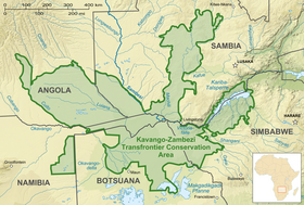
- Luengue-Luiana National Park, 22,610 km2, Kuando Kubango Province, Southeast, within the Kavango-Zambeze Conservation Area, cross-border. Flowers dense dry, savannah with shrubs and trees in the northeast, in the southeast is the Luiana partial reserve, which has precious woods.
- Mavinga National Park, 5,950 km2. Extensive and undulating plains, shrubs savannah and curls of miombo forest. Guepardos, lions, hyenas, leopard, rhinoceros, zebra, hippos, antelopes, impalas, buffaloes, etc. North of the Kavango-Zambeze Conservation Area in the south-east of the country.
- Buffalo partial reserve, 400 km2, 30 km from Benguela.
- Partial reserve of Namibe, on the southwest coast, 4.450 km2. Desert area, dunes and narrow plains and wild mountains. Sterling vegetation with savannah, elephants, oryx, black rhinoceros.
- Integral natural reserve of Ilhéu dos Pássaros, 2 km2. The islet is 1.7 km2, southwest of Luanda. It suffers from regular floods and predominant vegetation are mangroves. In June and August, the average temperature is 20.orC, in March, the warmest and rainiest month, of 27.orC. Precipitations are 450 mm per year. There are hardly mammals, but birds abound, especially herons, ibis and other aquatic birds.
- Integral natural reserve of Luando, 8.280 km2, center north the country, populated almost entirely by the bioma of the miombo.
- Chimalavera Regional Natural Park, 100 km2.
- Conservation area Kavango-Zambeze, 520.000 km2 transboundary park in the Okavango and Zambeze river basins covering five countries: Angola, Botswana, Namibia, Zambia and Zimbabwe.
Population and ethnic groups of Angola
The estimated population of Angola in 2021 was between 34 and 35.5 million inhabitants, with an average age of just over 16 years (in Spain it is 44 years), almost half of the population (48%) with less than 14 years of age and an annual increase of 3.3%, a first child at 19-20 years of age and an average of 6 children per woman, with a life expectancy of 62.2 years.
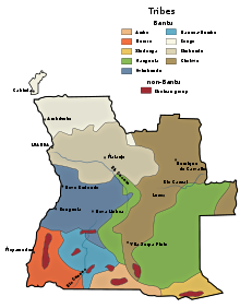
In Angola there are more than 50 African ethnic groups, in addition to a considerable population of Portuguese origin (about 2 million), about 50,000 Chinese, and a few thousand British, French, Afrikaners, Spanish (about 15,000) and Cape Verdeans. The official language is Portuguese, spoken by 72% of the population. They are followed by the umbundu (23%), the kikongo (8.2%), the kimbundu (7.8%), the chokwe (6.5%), the nyaneca (3.4%), the nganguela or luchazi (3.1%), fiote (2.4%), kuanyama (2.3%), muhumbi (2.1%), luvale (1%) and others, 3.6%. 41% are Catholic and 38% are Protestants.
Among the most important ethnic groups, the Ovimbundu (whose language is Umbundu) stand out, constituting 37% of the Angolan population, followed by the Kimbundu (25%), Bakongo (13%), mestizos (mixture of Europeans and African natives) (2%), Europeans (1%) and others (22%).
Minority groups include the Ovambo, Bolo or Haka (Kimbundu-speaking), Chokwe, Dhimba, Gciriku, Keikum, Herero, Holu, Hungu, !Kung, Kuvale, Kwandu, Xun, Lali, Lingala, Lozi, Luba, Luchazi, Luimbi, Lunda, Luvale, Luyana, Lualva, Masi, Mbangala, Mbukushu, Mbunda, Mbwela, the Mpinda, the Ndombe, the Ngandyera, the Ngendelengo, the Nkangala, the Nngela, the Pygmies (about 24,000 of the Bakwe group), the Sama, the Simaa, the Songo or Nsongo, the Suku, the Vasekela Bushmen, the Yaka, the Yauma and the Yombe.
External links
- People of Angola, Britannica
- Angola Ethnic Groups, Study.com
- Largest Ethnic Groups In Angola, WorldAtlas
- World Directory of Minorities and Indigenous Peoples - Angola, Refworld
- Angola People 2020, Countries of the World
Contenido relacionado
Popocatepetl
Kawaguchi (Saitama)
Dennery District


