
Andes mountains
The Andes mountain range occupies the western part of South America, bordering its entire coast on the Pacific Ocean. It has a length of 8,500 kilometers, making it the longest continental mountain range on Earth. From its northern end, in western Venezuela, it crosses Colombia and Ecuador; in the center of South America it crosses Peru and Bolivia; in the south, it serves as a natural border between Chile and Argentina, and has its southern end in Tierra del Fuego. It has a variable width of between 250 and 750 km. It occupies an approximate area of 2,870,000 km². Its average height is between 3,000 and 4,000 m s. no. m., is home to the highest volcanoes on the planet and its highest point is Aconcagua, whose 6962 m s. no. m. make this mountain the highest on the planet outside of Asia. Due to its significant volcanic activity, it forms part of the Pacific Ring of Fire.
In the central zone, the Andes widen, giving rise to the high plateaus of the altiplano and puna, shared by Argentina, Bolivia, Chile and Peru. From the central highlands to the north of Peru and in Ecuador it becomes narrow again and in Colombia it becomes wide by dividing into three branches, the Western Cordillera, the Central Cordillera and the Eastern Cordillera, the latter continuing northwest entering Venezuela becoming the Merida Cordillera. being the only Andean chain in the country. From the highlands to the south, the mountain range has a general north-south direction, the area where the highest mountains are found. At the southern end, it curves and takes an east-west direction and plunges into the Atlantic Ocean to the east of Isla de los Estados.
It was formed at the end of the Mesozoic era, at the end of the late Cretaceous, by the movement of the convergence of the Nazca plate under the South American plate. Seismic movements and subsequent volcanic activity have been more important in shaping the relief than external erosive agents. In the current morphology there are high mountain ranges, along with extensive plateaus and deep longitudinal valleys parallel to the great mountain axes. The transversal valleys are scarce, except in the Argentine-Chilean Andes.
Many of the world's major metallic mineral deposits are associated with convergent plate boundaries, such as the Andes or the Rocky Mountains.[citation needed]
Etymology
.jpg)
The word Andes comes from the word anti of the Quechua language which means 'east, cardinal point where the sun rises'.
The way in which it became the name of the mountain range is explained in Comentarios reales de los Incas, written by the Inca Garcilaso de la Vega:
The Incas kings divided their empire into four parts that called Tihuantin-Suyu, which means “The four parts of the world” according to the four main parts of heaven: east, west, septhion and midday. They put the eastern part Antisuyu, through a province called Anti which is east, by which they also call Anti to all that snowy mountain range that passes to the east of Peru.Inca Garcilaso de la Vega
Other compound words that contain the particle anti are: antiruna ('inhabitant of the east, of the Andes') and anti unquy ('mal de los Andes')
The change from Quechua Anti to Spanish Andes is explained because in Quechua the sound expressed by the consonant d is not used.
There is another etymology according to which anti could come from anta which means 'copper'. The German philologist Johann Karl Eduard Buschmann proved that this could not be true as Quechua retains the final a in compound words, as in Antamarka ('copper province').
Geology
The solid surface layer of the Earth, called the lithosphere, is divided into relatively rigid fragments, called tectonic plates, which move on the asthenosphere, a relatively plastic zone. There are 15 large plates and more than 40 micro plates. The plates include an upper layer called crust which can be oceanic or continental crust and thus the plates can be classified into oceanic and mixed plates. The Andes mountain range originates from the interaction of the Nazca oceanic plate with the continental part of the South American plate. In its northern and southern zones, the Cocos and Antarctic plates and the northern Andes microplate also participate in the process.

The boundaries between plates can be classified according to the type of relative motion between them. They can be divergent, convergent or friction. The formation of continental mountains, a process called orogenesis, as well as earthquakes, take place at the convergent limits. In these processes of subduction or collision can occur. Collision processes take place when two continental masses approach each other. The process of subduction occurs when one of the plates folds, towards the interior of the Earth, and enters under the other. The Andes have been uplifted by the subduction of oceanic plates beneath the South American plate. The plates that are currently subducted are the Cocos, Nazca and Antarctica. The subduction of the Nazca plates has a speed of 7-9 cm/year and that of the Antarctic, of 2 cm/year. The subduction processes include the generation of an oceanic trench which in the case of the Andes is the Peru-Chile or Atacama trench.
The Andes mountain range has volcanic activity that is associated with an angle of convergence of the oceanic plates greater than 25° and the partial melting of the mantle wedge that usually occurs in subduction zones.
The western margin of South America had been the scene of several orogenies in different geological eras. But the main process by which the mountain range has reached its current configuration, called Andean orogeny, has been active from the Jurassic to the present. With important periods of reorganization in the Cretaceous (90 million years ago) and the Oligocene (30 Ma).
In the Peruvian and Patagonian Andes, a large part of the massifs correspond to tonalite, granite, diorite and granodiorite batholiths that correspond to ancient magma chambers that have been exposed by a combination of tectonic uplift and erosion. The largest batholiths are the Peruvian Coastal Batholith, the North-Patagonian Batholith, and the South-Patagonian Batholith.
Zoning
Throughout its great length, the Andes mountain range can be divided into sectors or zones. There are various continental-scale zonings according to various criteria that attempt to transcend political-administrative divisions, according to which one usually speaks of the Venezuelan, Colombian, Ecuadorian Andes, etc.
Geology
In 1973, the geologist Augusto Gansser proposed a division, now considered classical, which takes into account the relationship of the oceanic tectonic plates with the continent.

- Northern and Northern Andes: They develop from their north end to the Gulf of Guayaquil (4.o S) in Ecuador where the dorsal of Carnegie touches the continent. In this area are the Venezuelan, Colombian and Ecuadorian Andes. They present a mountain range or beam management. This segment is the result of the complex interaction between the tectonic plates Nazca, Caribe and Suramérica and discrete lithospheric elements such as the Panama-Choco Block and the Norandino Block which, according to other authors, constitute smaller plates called Panama plate and North Andes plate.
- Central: They develop between the Gulf of Guayaquil and the Gulf of Penas (46o 30'), Chile. In this area are the Peruvian Andes, Bolivians and much of the Argentine-Chinese. This area is bordered by the plate of Nazca which is subdivided by the dorsal of Nazca which is a volcanicly inactive dorsal (asystemic). In this area the Western Cordillera and the Eastern Cordillera border the plateaus of the Altiplano and Puna. It is the largest area and is usually subdivided into northern, central and southern sectors. Central Andes include, a Peruvian segment extending from northwest to southeast called the North Central Andesand a part of the Andes of Chile and Argentina with north-south direction called the South Central Andes.
- South or Southern Andes: They develop south of the Gulf of Penas, where the dorsal of Chile plays the continent constituting the triple point of Aysén or Chile, where the South American plates with those of Nazca and the Antarctica are found.
The Northern and Southern Andes are less than 150 km wide and less than 2,500 m in average elevation, while the Central Andes reach an average width of 800 km and greater elevations.
Both the northern and southern Andes are also called Collisional-type Andes, because they were formed by the abduction of oceanic crust. The central Andes correspond to the so-called Andean-type Andes, developed by subduction of the marine crust.
Another criterion to establish a zoning is volcanic activity. According to this criterion, the Andes mountain range is divided into four segments of activity:

- North volcanic zone: (5°N - 2°S) between the latitude of Bogotá and the latitude of Guayaquil.
- Central volcanic zone: (14° - 27°) between the latitude of Lake Titicaca and the southern boundary of the Atacama Desert.
- South volcanic zone (33° - 46°) between the latitudes of Santiago de Chile to the latitude of the Gulf of Penas.
- Southern volcanic zone (49° - 55°) south of the Gulf of Penas.
Among them there are zones without volcanism, which are related to a convergence angle of less than 10° constituting 3 horizontal or sub-horizontal subduction zones and an inactivity gap. These are, from north to south:
- From Bucaramanga
- Peruana
- Pampeana
- Patagonica Brecha
In 2003, A. Tassara and G. Yáñez, based on the elastic thickness of the lithosphere, proposed a division of four segments:
- Andes from the north: up to a latitude of 15°S, including northern Peru
- Central (15-33.5°S), containing the segments: Altiplano (15-23°S), Puna (23-28°S) and Cordillera Frontal (28-33.5°S);
- South Andes (33.5-47°S) contains segments: Cordillera Principal (33.5-39°S) and Cordillera patagónica (39-47°S).
- Andes australes (47-56°S)
Morphological and geographic
Other authors recover a different zoning taking into account the orographic knots, which are the points where various mountain ranges and other geographical criteria converge.
- Northern Andes: They extend from the depression of Barquisimeto-Carora in Venezuela to Pasco's knot or Bombon's plateau (10.o S) in Peru
- Central: Between the knot of Pasco and the snow-capped Tres Cruces (27o S) between Chile and Argentina.
- Southern Andes: from the snowy Three Crosses to the island of States, east of Tierra del Fuego.
Due to its position in the geoastronomical zones, the mountain range can be divided into Tropical Andes and Extra-tropical Andes. Crossing with the previous zoning, the northern and central Andes are tropical Andes, where all the thermal floors develop, which are the different climatic types that are mainly related to altitude. The southern Andes are extra-tropical Andes.
Northern Andes

They are characterized by having parallel ridges gathered in orographic knots separated by deep river valleys as in Colombia or enclosing highlands as in Ecuador.
In the south of Colombia, on the border with Ecuador, the Andes form a single mountain range with volcanic peaks up to 5000 m s. no. m.; To the north, at the Pastos knot, it quickly divides into two mountain ranges called the Western and Central ranges, respectively — the Eastern one is detached from the latter.

The Central Cordillera is separated from the Western Cordillera by an average distance of 400 km by a geological fault line occupied by the Patía River to the south and the Cauca River to the north. The Cordillera Oriental gradually separates to the east, creating the basin of Colombia's most important river, the Magdalena. This mountain range extends to the north and in the department of Norte de Santander it is subdivided into two arms. The eastern arm penetrates the Venezuelan territory, where it acquires the name of Cordillera de Mérida, whose natural continuations give way to the Lara-Falcón formation and are distantly related to the mountain ranges of the Central (Caracas, Valencia and Maracay) and Eastern (Barcelona) coasts. and Puerto La Cruz). The Mérida mountain range is the highest mountain range in Venezuela, having its maximum point at the Bolívar peak (4978 m.a.s.l.). Together with the Perijá mountain range, shared with Colombia, they make up the Venezuelan branch of the Andes Mountains. The mountain range is made up of various mountain ranges, the best known being the Sierra Nevada de Mérida and the Sierra La Culata, both located in the middle zone of the mountain range within the state of Mérida.

The Cordillera de Mérida is located in the western part of Venezuela, encompassing the states of Táchira, Apure, Barinas, Mérida, Trujillo and Lara, beginning in the Táchira depression on the border between Colombia and Venezuela, extending for about 425 kilometers to the Barquisimeto-Carora depression in Lara state.
The western arm, called the Serranía del Perijá, emerges from it to the north, forming the Colombian-Venezuelan natural border and gradually loses height in the Guajira peninsula, in the extreme north of Colombia. In the Perijá it approaches the Sierra Nevada de Santa Marta, a mountainous system isolated from the Andes, forming a valley furrowed by the César River.
All three ranges have mainly volcanically formed peaks over 4,000 m s. no. m. La Central and La Oriental have peaks of more than 5000 m s. no. m. covered with permanent snow. Many of these volcanoes are active and have caused destruction and deaths in the past due to gas and ash explosions, as well as ice and mud avalanches. The west of the country is subject to greater telluric activity, which demonstrates the instability of its geological nature. To the northwest of the Western Cordillera appears a mountain system called the Baudó mountain range, which continues through the Darién turning west towards Panama.
From the Huancabamba depression, heading south, the Marañón and Santa rivers form important divisions, the Marañón canyon and the Callejón de Huaylas respectively, the latter dividing the Cordillera Blanca from the Cordillera Negra. In a southerly direction, the Western Cordillera continues through the Huayhuash Cordillera and allows the formation of the Bombón plateau, which is orographically called the “Pasco knot”.
Important cities in the northern Andes are Bogotá, Soacha, Medellín, Cali, Bucaramanga, Manizales, Pereira, Armenia, Popayán, Tunja, Cúcuta, Ibagué and Pasto in Colombia; Quito, Cuenca, Loja, Riobamba and Ambato in Ecuador; and Caracas, San Cristóbal, Mérida, Valera, Trujillo and Barquisimeto in Venezuela.
Central Andes

The Central Andes extend from Peru to the snow-capped Tres Cruces, located on the border between Argentina and Chile. It is the widest area. They are characterized by being continuous and high; It does not have a single mountain pass below 4,000 m. The arrangement of the mountain ranges is made up of two ranges separated by the Andean plateau. Argentinian-Chilean, the snow-capped Ojos del Salado (6891 m.a.s.l.).
To the south of the Nudo de Pasco, the tributaries of the Apurímac River make up a region furrowed by numerous alluvial canyons. To the north of the Apurímac basin, the Vilcanota also forms an alluvial valley that begins in the area of glaciers that delimit the Collao Plateau. Towards parallel 15°S the Central Volcanic Zone begins in the Sara Sara. The aforementioned Meseta del Collao, or simply the Altiplano, dominates the landscape south of 15 °C for the central sector of the Andes. Two large lakes are located on this plateau, Titicaca and Poopó, which make up the most extensive endorheic system in South America. The population is more concentrated in the highlands and on the periandean coast, as is the case of the Peruvian capital, Lima, whose metropolitan area reaches up to 950 m a.s.l. no. m.

Among the most important inter-Andean cities located in this sector of the mountain range are Arequipa, Huamanga, Puno, Tacna, Cajamarca, Huancayo and Cuzco in Peru; and La Paz, Sucre, Potosí, Cochabamba and Oruro in Bolivia.
The Andes mountain range, upon entering Bolivian territory, branches into various sectors and forms the Western or Volcanic and Eastern or Real mountain ranges, in the middle of which is the Bolivian altiplano.
Towards the 22°S parallel, the Puna de Atacama appears, dominating the west of the volcanic zone. The climate is cold arid and the predominant biome is desert in the highlands and its mountain ranges, in the valleys the climate is temperate most of the year, warm in summers (20°- 35°), cold in winters (05°- 20 °).
Southern Andes
,_Regi%C3%B3n_de_Atacama,_Chile.jpg)
Also called southern or southern Andes, due to their latitude they are also called extratropical Andes. It is made up of the following subregions:
- You are arid: It extends from Cerro Tres Cruces to Paso de Pino Hachado (38o 40' S) They stand out for its aridity. Here are large heights such as the Aconcagua hill (6960 m. n. m.), the Tupungato volcano (6638 m. n. m.) and the Mercedario hill (6720 m. n. m.) although the average height descends. The steps are difficult and steep. To the west is the Chilean middle depression, a longitudinal valley between 10 and 40 km wide, that separates the Andes from the Cordillera de la Costa, which barely exceeds the 2000 m. n. m. altitude.

- Andes patagónicos: They extend south of the Pino Hachado Pass. Here the heights descend drastically due in part to glacial erosion and at the same time due to the complexity of the subduction process between the plates of Nazca and South America, the first penetrates to greater depth and in lesser extent, this led to a lower elevation compared to more northern areas. Another characteristic is the presence of steps, which allow the entry of wet winds of the Pacific and the development of the Patagonian Andean forest, and thus the settlement of the population at the foot of the mountain range. The presence of geoforms from glacial action such as lakes, glacial circuses, morrenas and extensive ice fields from which several glaciers descend. The main heights are the Domuyo Volcano[chuckles]required] (4707 m. n. m), Lanín volcano (3776 m. n. m.) and Tronador hill (3554 m. n. m.) and in the area australMount Valentine (3910 m. n. m). This area also highlights Mount Fitz Roy or Mount Chaltén (3375 m s. n. m.), Mount Torre (3133 m. n. m.), Mount Paine Grande (3240 m. n. m.) and the towers of the towers (3000 m. n Pain m.) monumental peaks that, have been a great challenge for andinism for decades. Here are two large ice fields, the Patagonian southern and northern icefield. The first of these associated with Perito Moreno Glacier visited by hundreds of thousands of tourists annually. Beyond the Strait of Magellan, the mountain range continues in Andes wasguinos ending on the island of States.
Cities and settlements
The Andes Mountains form a north-south axis of cultural influences. A long series of cultural development culminated in the expansion of the Inca civilization and the Inca Empire into the central Andes during the 15th century. The Incas formed this civilization through imperialist militarism and careful and meticulous government management. The government sponsored the construction of aqueducts and roads in addition to pre-existing facilities. Some of these constructions still exist today. Devastated by European diseases to which they had no immunity and civil wars, the Incas were defeated in 1532 by an alliance made up of tens of thousands of allies from nations they had subjugated (eg, Huancas, Chachapoyas, Cañaris) and a small army of 180 Spanish led by Francisco Pizarro. One of the few Inca sites the Spanish never encountered in their conquest was Machu Picchu, which lay hidden on a peak at the eastern edge of the Andes, where they descend into the Amazon. The main surviving languages of the Andean peoples are those of the Quechua and Aymara language families. Woodbine Parish and Joseph Barclay Pentland surveyed much of the Bolivian Andes between 1826 and 1827.
Cities
Today, the largest cities in the Andes are Bogotá, with a population of around eleven million, Santiago, Medellín, Caracas and Cali, respectively. Lima is a coastal city adjacent to the Andes. It is also the headquarters of the Andean Community.
La Paz, the seat of government of Bolivia, is the highest metropolis in the world, at an elevation of approximately 3650 m a.s.l. no. m.. Parts of the La Paz conurbation, including the city of El Alto, extend up to 4,200 m (13,780 ft).
Other cities in or near the Andes include: Jujuy, Salta, Tucumán, Catamarca, La Rioja, San Juan, Mendoza, Neuquén and Bariloche in Argentina; Cochabamba, Oruro, Potosí, Sacaba, Sucre in Bolivia; Calama, San Pedro de Atacama and Rancagua in Chile; Armenia, Cúcuta, Bucaramanga, Ibagué, Manizales, Popayán, Tunja, Soacha and Pasto in Colombia; Ambato, Cuenca, Ibarra, Loja, Quito, Riobamba and Tulcán in Ecuador; Arequipa, Cajamarca, Cusco, Huancayo, Huánuco, Huaraz, Cerro de Pasco, Juliaca and Puno in Peru and Barquisimeto, Mérida, San Cristóbal and Valera in Venezuela. The cities of Caracas, Valencia, and Maracay are located in the Venezuelan Coastal Range, which is an extension of the Andes in the far north of South America.
- Large cities in the Andes Mountain Range

Bogotá, the most populous city in the mountain range.

La Paz, the world's highest metropolis; the snowy Illimani to the bottom.

Quito, the highest capital of the world and the mountain range.
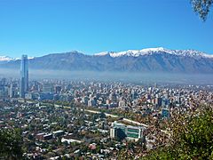
Santiago, view from Cerro San Cristobal.


.JPG)
Sports and recreation


The natural beauties of the region, pre-Inca and Inca ruins in Bolivia, Peru and Ecuador, and the possibility of easy access to glaciers in southern Argentina and Chile, have attracted large-scale tourism. Next to the mountain range are cities such as San Carlos de Bariloche or Colonia Suiza. Ushuaia has contrasting landscapes with the high peaks and the sea. In Venezuela, there is the Mérida cable car, which is the highest and the second longest in the world. In Chile, there are a large number of ski and winter sports centers.
The Andes present optimal conditions for carrying out various sports such as mountaineering, hiking and rafting. Skiing, snowboarding and other winter sports are highly developed in Argentina and Chile. The Transitional Andes is home to the largest concentration of ski resorts in the southern hemisphere, after New Zealand.
These are some of the ski resorts in the Andes:
- Argentina
- Altos del Valle, Batea Mahuida, Caviahue, Cerro Bayo, Cerro Castor, Cerro Catedral, Cerro Wayle, Chapelco, Martial Winter Complex, La Hoya, Las Cotorras, Las Leñas, Llanos del Castor, Los Penitentes, Nunatak, Primeros Pinos, Solar del Bosque, Tierra Mayor, Valdelén, Vallecitoes, Valle de los Hermosski
- Bolivia
- Chacaltaya
- Chile
- Antillanca, Antuco, Cerro El Fraile, Cerro Mirador, Chapa Verde, Corralco, El Arpa, El Colorado, Farellones, La Parva, Las Araucarias, Los Arenales, Lagunillas, Portillo, Termas de Chillán, Valle Nevado, which has one of the largest skiable areas in South America; Villarrica and Volcano Osorno
Antartandes

The Andes extend to the east of the Isla de los Estados (Tierra del Fuego) forming an underwater mountain range called the Scotia Ridge, which only manages to emerge above the oceanic waters in the highest peaks or sectors of the same, thus generating islands, which are called South Antilles: Aurora Islands, South Georgia, Clerke Rocks, South Sandwich Islands, South Orcadas and South Shetland. The Andes emerge again as a mountain range in Antarctica with the name of Antartandes, the great mountain range of the Antarctic peninsula.
The maximum height of the Antartandes is Mount Coman with 3657 m s. no. m., in the mountain range called Montes de la Eternidad; Mount Esperanza also stands out with 2860 m s. no. m. From the Antartandes extends a branch to the southwest known as the Ellsworth Mountains, a low and largely subglacial mountain range that connects the Antartandes with the other great Antarctic mountain range: the Transantarctic Mountains. In these, more precisely in the segment called Cordillera Diamante, the highest altitude of Argentine Antarctica and the British Antarctic Territory is located, the nunatak mount Chiriguano with 3660 m a.s.l. no. m. Towards the geographic South Pole is the Polar Plateau.
Highest Peaks
The highest summit of the Andes mountain range is Aconcagua, which, with 6962 m a.s.l. no. m., It is the second highest point in the world after the Asian Himalayan system, as well as being the highest point in the southern and western hemispheres. It is located in Mendoza, Argentina.
Argentina and Chile share the highest peaks of the Andes; among them, the Nevado Ojos del Salado, the highest volcano in the world and the second highest peak on the continent — of the ten highest volcanoes on the planet, six are shared between Argentina and Chile, three are in Argentina and one in Bolivia. These summits are followed by the Cordillera Blanca located in Peru, the Cordillera Real in Bolivia, and the Ecuadorian Andes.
In the south of Peru, near Cuzco, is the Vilcanota mountain range, where the Quelccaya glacier is located, the largest glacier in the entire intertropical zone of the world. This singularity has allowed us to study in its ice the climatic changes that have occurred in the tropics since the last ice age.
| Altitude | Name | Cordillera | Location | Country |
|---|---|---|---|---|
| 6962 | Aconcagua | Cordillera Frontal | Province of Mendoza | |
| 6891 | Nevado Ojos del Salado | Puna de Atacama | Catamarca Province Atacama Region | Chile |
| 6795 | Monte Pissis | Puna de Atacama | La Rioja Province Catamarca Province | |
| 6720 | Cerro Mercedario | Cordillera de la Ramada | San Juan Province | |
| 6768 | Nevado Huascarán | Cordillera Blanca | Department of Áncash | Peru |
| 6759 | Cerro Bonete | Puna de Atacama | Province of La Rioja | |
| 6750 | Nevado Tres Cruces | Puna de Atacama | Catamarca Province Atacama Region | Chile |
| 6740 | Volcano Llullaillaco | Western mountain range | Salta Province Antofagasta Region | Chile |
| 6660 | Volcano Walther Penck | Puna de Atacama | Catamarca Province | |
| 6642 | Volcano Incahuasi | Puna de Atacama | Catamarca Province Atacama Region | Chile |
| Altitude | Name | Cordillera | Location | Country |
|---|---|---|---|---|
| 6960 | Cerro Aconcagua | Cordillera Frontal | Province of Mendoza | |
| 6891 | Nevado Ojos del Salado | Puna de Atacama | Catamarca Province Atacama Region | Chile |
| 6768 | Nevado Huascarán | Cordillera Blanca | Department of Áncash | Peru |
| 6540 | Nevado Sajama | Western mountain range | Oruro Department | Bolivia |
| 6285 | Chimborazo Volcano | Western mountain range | Chimborazo Province | Ecuador |
| 5410 | Ritacuba White | Cordillera Oriental | Boyacá | Colombia |
| 4980 | Pico Bolívar | Cordillera de Mérida | State Mérida | Venezuela |


Higher mountain passes
Undoubtedly, it would be very difficult to make a list of the highest mountain passes in the Andean countries given the large number of them.
Therefore, a list will be made of the highest by country ordered from highest to lowest altitude, according to the data obtained today. Discrimination will be made between paved and unpaved ports, most of them being gravel roads passable by 4x4 cars.
| Mountain port | Country | Paved | Road | Altitude | |
|---|---|---|---|---|---|
| Step of Sairecabur | Chile | No. | 5530 |  | |
| Abra Huayta | Peru | No. | AR-661 | 5320 | |
| Abra Wallatani | Bolivia | No. | 5230 | ||
| Step of the Tortolas | Argentina | No. | 5080 | ||
| Alto de Mifafi | Venezuela | No. | Carretera Valle de Mifafi | 4415 | |
| High Salinas | Ecuador | No. | 4345 | ||
| Alto de Ventanas | Colombia | No. | Murillo-La Esperanza Road | 40451 |
()1: The paving of the road is in process. The road will only be widened to prohibit the passage of heavy vehicles. In short, a tourist corridor is sought so as not to affect the sustainability of Nevado del Ruíz given its proximity.
Biological diversity
It is known that humans inhabited the area for 12,000 years, shortly after their arrival in America.
Flora
The flora of the Andes mountain range includes especially the Altoandina phytogeographic province, one of the sections into which the Andean-Patagonian phytogeographic domain is divided. This phytogeographic province extends over the Andes and the summits of mountain ranges close to this cord, from the Andean mountain range of Venezuela and Colombia, along the west of South America, to the island of the States. Its flora is characterized by presenting formations of herbaceous steppes, for the most part, although there are also small bushes in sheltered places. Xerophytic grasses and creeping or cushion dicots dominate, with numerous endemic genera.

YaretaAzorella sp.)

Ichu Pajonal (Stipa ichu).

.jpg)
Wildlife
Among the characteristic fauna species, the South American camelids stand out. Of these, the guanaco is the most widespread, living over the Andes from Peru to the Big Island of Tierra del Fuego. In the central Andes the vicuña lives, which coexists with two domestic species: the llama and the alpaca. All these artiodactyls are preyed on by the puma and the red or culpeo fox, which prefers to hunt vizcachas from the mountains. However, the Andean condor is the archetypal animal of this mountain range, which inhabits it in its entirety, from Venezuela to the southern tip. The lakes and wetlands present a high diversity of aquatic birds, most of them are endemic to the Andean highlands, highlighting the cohabitation of three species of flamingos.
There are a large number of endemic butterfly species in the Andes. Particularly the genus Catasticta (piéride family), Lycaenidae family and the Andean black butterflies (Pronophilina subtribe, Nymphalidae family).

Andean condor (Vultur gryphus)

Cocktail of the rocks (Rupicola peruvianus)

Guanaco (Lama guanicoe)

Vizcacha de la sierra (Lagidium viscacia)

Puma (Puma concolor)

Red fox or body (Lycalopex culpaeus)


Contenido relacionado
Iōtō
South Africa Geography
Madagascar Geography