Aldeatejada
Aldeatejada is a Spanish municipality and town in the province of Salamanca, in the autonomous community of Castilla y León. It is integrated within the region of Campo de Salamanca (Campo Charro). It belongs to the judicial district of Salamanca.
Its municipal area is made up of the towns of Aldeatejada, El Soto, Finca La Cordillera, Las Peñas, Los Hoyos, Otero Vaciadores, Porquerizos, Salvadorique, Sanchoviejo and Vistahermosa, as well as the unpopulated areas of Montalvo Mayor, Montalvo Primero, Teso del Cercado and Villa Benito, occupies a total area of 31.51 km² and according to data prepared by the INE in 2020, it has 2,210 inhabitants. It is located 6 km by road from Salamanca.
Toponymy
The place name Aldeatejada derives from the name Aldea Teiada with which the town appears for the first time, in a document dated April 20, 1186, in which Velasquita, Xemena and Velasco sold an orchard and vineyard to Iohannis Cormano in the town. Likewise, another document from April 1210, includes the town with the place name of Aldea Tellada, in a contract that includes the sale of an orchard in this town by Roderico de Aldea Tellada to Gonçalo Pelaez, notary public of the King of León. Later, in September 1213, the town appears again as Aldea Tellada in a document in which Gundissalvus Pelagii, canon of Salamanca, donates to the Diocese the orchard he owned in the town, whose name was later would have derived from Aldeatellada to Aldeatejada.
Symbols
Shield
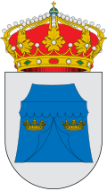
The heraldic shield that represents the municipality was approved on June 2, 1966 with the following coat of arms:
"Silver Shield, the slurry tent, square, with tilted covers and door, is accompanied by two royal crowns of gold. To the bell, the royal crown closed»Official State Gazette No. 159 of 5 July 1966
History
Its foundation dates back to the repopulation carried out by the kings of León in the Middle Ages, being integrated into the quarter of Peña del Rey of the jurisdiction of Salamanca, within the Kingdom of León, being called in the century XIII Aldeatellada. Later, between November 10 and 13, 1543, one of the main events in the history of Aldeatejada took place, since Felipe II and María Manuela of Portugal remained in this town, who were handcuffed two days later in the city of Salamanca. On the other hand, in 1626 the church of Aldeatejada was affected by the overflow of the Tormes river, in what is known as Riada de San Policarpo, which swept away three houses in the town. With the creation of the current provinces in 1833, Aldeatejada was framed in the province of Salamanca, within the Leonese Region. The Cañada Real de la Plata or Vizana passes through here.
Demographics
| Graphic of demographic evolution of Aldeatejada between 1900 and 2021 |
 |
Source: Spanish National Statistical Institute - Graphical development by Wikipedia. |
Population centers
The municipality is divided into several population centers, which had the following population in 2017 according to the INE.
| Population Core | Population |
|---|---|
| Aldeate | 1795 |
| Beautiful view | 47 |
| Las Peñas | 11 |
| Sanchoviejo | 6 |
| Salvadorique | 6 |
| The Hoyos | 5 |
| Finca La Cordillera | 2 |
| Near Thess | 2 |
| Urbanization The Soto | 2 |
| Otero Emptying | 1 |
| Why? | 1 |
| Villa Benito | 0 |
| Montalvo Mayor | 0 |
| Montalvo First | 0 |
Administration and politics
Municipal elections
| Political party | 2019 | 2015 | 2011 | 2007 | 2003 | ||||||||||
|---|---|---|---|---|---|---|---|---|---|---|---|---|---|---|---|
| % | Votes | Councillors | % | Votes | Councillors | % | Votes | Councillors | % | Votes | Councillors | % | Votes | Councillors | |
| Spanish Socialist Workers Party (PSOE) | 36,98 | 429 | 4 | 36,63 | 326 | 4 | 24,86 | 180 | 2 | 22,88 | 140 | 1 | 27,91 | 139 | 2 |
| Popular Party (PP) | 34,57 | 401 | 3 | 41,91 | 373 | 4 | 69.48 | 503 | 7 | 62.09 | 380 | 5 | 38.96 | 194 | 3 |
| Citizens (Cs) | 27,24 | 316 | 2 | 13,82 | 123 | 1 | - | - | - | - | - | - | - | - | - |
| Union Progreso and Democracy (UPyD) | - | - | - | 4.94 | 44 | 0 | - | - | - | - | - | - | - | - | - |
| Union of the Salmantino People (UPSa) | - | - | - | - | - | - | - | - | - | 11,93 | 73 | 1 | 27,51 | 137 | 2 |
Mayors

Transportation
The municipality is integrated within the metropolitan area of Salamanca, less than 10km from the center of the capital, so it is very well connected by road and has direct access to the Ruta de la Plata highway that connects Gijón with Seville and to the SA-20, the southern roundabout that encircles the city. Also noteworthy is the CL-512 highway that connects Salamanca with Vecinos, crossing the urban center and the DSA-210 highway that arises from the junction with the latter and connects with Las Veguillas.
As far as public transport is concerned, after the closure of the Vía de la Plata railway route, there are no train services in the municipality or in the neighbourhoods. It has a regular bus service that connects with the provincial capital with frequencies of one hour on weekdays that decrease on Saturdays. On the other hand, Salamanca Airport is the closest, being about 22km away.
Contenido relacionado
Saint Louis Province
Chaco
Morale of Hornuez


