
Adriatic sea
The Adriatic Sea (from Latin, Mare Hadriaticum) is a narrow, elongated gulf that forms part of the Mediterranean Sea. It is located between the Italian peninsula, to the west, and the Balkan peninsula, to the east, with a maximum width of about 200 km, and a length of about 800 km. Its southern end borders the Ionian Sea, from which it is separated by the Otranto channel. Its total area is approximately 138,600 km².
The western, northern, and part of the eastern coasts correspond to Italy (60% of the Adriatic coastline length), while the rest of the eastern coast corresponds to Croatia, Slovenia, Bosnia and Herzegovina, Montenegro and Albania. Some of the rivers that flow into the Adriatic are the Reno, the Po, the Adige, the Brenta, the Piave and the Neretva.
The Adriatic coast concentrates a large number of tourist centers, such as Venice, which is called the "Queen of the Adriatic". After the division of Yugoslavia, the Croatian coast has also become a very popular tourist destination.
Its waters support the fishing industry, and oil prospecting is carried out in this sea. During the 1990s, several investigations revealed that its contamination levels are very high.
In recent decades the Italian government has tried to make it a barrier against illegal immigration, mostly from Albania.
Name and etymology
The origins of the name Adriatic are related to the Etruscan settlement of Adria, which probably derives its name from the Illyrian adur meaning water or sea.
This sea has received different names since ancient times; in the Latin of the ancient Romans (Old Latin) it was called Mare Superum; in medieval Latin it was Mare Hadriaticum or Mare Adriaticum, while, during the Renaissance, it was called Golfo di Venezia because it was dominated by the Republic of Venice (Venice, in the 16th, 17th and 18th centuries, used to be called the "Queen of the Adriatic& #3. 4;).

The ancient Romans used to transport goods (including animals and slaves) to Ostia Aterni (Pescara, a Roman port) through this sea, while the Venetians used it as a trade route from Europe West to East.
Its name, derived from the Etruscan colony of Adria (or Hadria), was originally designated only to the upper portion of the sea, but gradually spread as the Syracusan colonies gained importance.
But even then, the Adriatic, in the narrowest sense, did not extend beyond Mount Gargano, and the outer portion was called the Ionian Sea; however, the name was sometimes mistakenly used to include the Gulf of Tarentum (now the Gulf of Tarentum), the Sea of Sicily, the Gulf of Corinth, and even the sea located between Crete and Malta.
The Adriatic Sea lies mostly between the Italian and Croatian coasts, both areas being major tourist attractions.
The different ways in which this sea is called in the countries that surround it are the following:
- Italian: Mare Adriatico.
- Albanés: Deti Adriatik.
- Slovenian: Jadransko morje.
- Croatian and Bosnian: Jadransko more (in colloquial use also Jadran).
- Montenegrino: Jadransko more or in the Cyrillic alphabet.адранско море.
Geography

The Adriatic is a semi-enclosed sea, bounded to the southwest by the Apennines or the Italian Peninsula, to the northwest by the Italian regions of Veneto and Friuli-Venezia Giulia, and to the northeast by Slovenia, Croatia, Bosnia-Herzegovina, Montenegro and Albania, the Balkan Peninsula. In the southeast, the Adriatic Sea joins the Ionian Sea at the 72-kilometre-wide Strait of Otranto. The International Hydrographic Organization (IHO) defines the boundary between the Adriatic and Ionian seas as a line running from the mouth of the Butrinto River (latitude 39°44'N) in Albania to Cape Karagol in Corfu, passing through this island to Cape Kephali (these two capes are at latitude 39°45'N), and to Cape Santa Maria di Leuca (latitude 39°48'N). It extends 800 kilometers (500 mi) from the northwest to southeast and is 200 kilometers (120 mi) wide. It covers 138,600 square kilometers and has a volume of 35,000 cubic kilometers. The Adriatic stretches northwest from 40° to 45°47'; north latitude, representing the northernmost part of the Mediterranean. The sea is divided geographically into the North Adriatic, the Central (or Middle) Adriatic, and the South Adriatic.
Exclusive Economic Zone
Exclusive economic zones in the Adriatic Sea:
| Number | Country | Area (km2) |
|---|---|---|
| 1 | Italy | 63 600 |
| 2 | Croatia | 55 961 |
| 3 | Albania | 11 105 |
| 4 | Montenegro | 7460 |
| 5 | Slovenia | 192 |
| 6 | Bosnia and Herzegovina | 50 |
| Total | Adriatic Sea | 138 600 |
Extent and bathymetry

The average depth of the Adriatic is 259.5 meters, and its maximum depth is 1,233 meters; however, the North Adriatic Basin rarely exceeds 100 meters (330 ft) depth. The base of the North Adriatic Basin, which stretches between Venice and Trieste towards a line between Ancona and Zadar, is only 15 meters deep at its northwest end; it gradually deepens to the southeast. It is the largest shelf in the Mediterranean and is both a dilution basin and a place of bottom water formation. The Middle Adriatic Basin lies south of the Ancona-Zadar line, with the 270-meter Middle Adriatic Trench. meters deep (also called Pomo Depression or Jabuka Trench). To the south of the Middle Adriatic Trench is the 170-meter-deep Palagruža Trench, which separates it from the 1,200-meter-deep South Adriatic Trench and the Middle Adriatic Basin from the South Adriatic Basin. Further south, the seabed rises to 780 meters to form the Otranto Trench on the border with the Ionian Sea. The South Adriatic basin is similar in many ways to the North Ionian Sea, with which it is connected.
The Adriatic stretches from 40° northwest to 45° 45' N, with an extreme length of about 770 km (415 nmi, 480 mi). It has an average width of around 160 km, although in the Otranto channel, through which it connects with the Ionian Sea, this width is only 85-100 km.
In addition, the series of islands off the coast of Croatia reduce the extreme width of the open sea in that area to 145 km. Its total area is about 138600 km².
The northern part of the sea is very shallow, and between the southern peninsulas of Istria and Rimini the depth rarely exceeds 46 m (25 fathoms). Between Šibenik and Ortona there is a well-marked depression, a considerable area exceeding 180 m (100 fathoms) in depth.
From a point between Korčula and the northern shore of Monte Gargano there is a ridge that leads to shallower water, and a broken chain of a few islets stretches across the sea.
The deepest part of the sea is to the east of Monte Gargano, south of Dubrovnik and west of Durrës, where a large trench presents depths of 900 m (500 fathoms) and up, and a small part in the south of this depression it reaches 1460 m (800 fathoms). The average depth of the sea is estimated at 240 m (132 fathoms).
Hydrology

surface currents benthic currents
The dynamics of coastal waters are determined by asymmetrical shorelines and the influx of seawater from the Mediterranean through the Strait of Otranto and further along the eastern coast. The smooth Italian coast (with very few ledges and no major islands) allows the Western Adriatic Current, made up of the relatively fresh surface water mass and the cold, dense bottom water mass, to flow smoothly. The coastal currents on the opposite shore are much more complex due to to the jagged coastline, several large islands and the proximity of the Dinaric Alps to the shore. The latter produces significant temperature variations between the sea and the inland, giving rise to the creation of local injectors. Tidal movement is normally slight, generally staying below 30 centimeters (12 in). The amphidromic point lies halfway east of Ancona.
Temperature and salinity
The surface temperature of the Adriatic is usually between 22 and 30 °C in summer and between 12 and 14 °C in winter, except in the northern part of the western Adriatic coast, where it drops to 9 °C in winter. The distinct seasonal temperature variations, with a longitudinal gradient in the north and a transverse one in the middle and southern Adriatic, are attributed to the continental characteristics of the Adriatic Sea: it is shallower and closer to land than the oceans. In particularly cold winters, sea ice can appear in the shallow coastal areas of the Adriatic, especially in the Venetian Lagoon, but also in isolated shoals as far south as Tisno (south of Zadar). The southern Adriatic is 8–10 °C (14–18 °F) warmer during winter than the more northerly regions. The variation in Adriatic salinity throughout the year is equally clear:[51] it ranges from 38 and 39 PSU. The southern Adriatic is subject to saltier waters from the Levantine basin.
Coasts and islands
The western Italian coast is generally low, joining, to the northwest, the marshes and lagoons of the protruding delta of the Po River, whose sediments have caused the coastline to push several miles out to sea — so much so that Adria is now some distance away of the coast.
Notable cities on Italy's Adriatic coast include Venice, Trieste, Ravenna, Rimini, Ancona, Giulianova, Pescara, Ortona, Vasto, Termoli, Trani, Bari, Brindisi, and Otranto.
The Italian part of the coast includes two large lagoons to the north (Venice and Marano-Grado), which have several hundred small and medium-sized islands.
The eastern Balkan coast is generally steep and rocky, with many islands. South of the Istrian Peninsula, which separates the Gulf of Venice and the Gulf of Trieste from the Gulf of Kvarner, the coastal island chain extends as far as Dubrovnik (the former Ragusa of Dalmatia).
Typically long and narrow (like long shafts running parallel to the mainland's shoreline), the islands rise steeply to heights of a few hundred feet, with the exception of a few larger islands such as Brač (its highest point is Vidova gora, with 778 m) or the Pelješac peninsula (its highest elevation is St. Ilija, with 961 m). There are more than a thousand islands in the Adriatic, of which 66 are uninhabited.
On the mainland, especially in the Bay of Kotor (also known as Boka Kotorska or Bocche di Cattaro, named after the town of Kotor-Cattaro), they are mountains that frequently fall directly into the sea.

The most common color of the rocks is light gray, which contrasts strongly with the dark vegetation, which on some of the islands is exuberant. In fact, Montenegro gets its name from the salt pines that cover its coastline. For its part, the Greek name for the island of Korčula is Korkyra Melaina, which means Black Corfu.
The main cities on the eastern coast (in brackets the native Italian name) are Izola (Isola d'Istria), Koper (Capodistria), Piran (Pirano) and Portorož (Portorose) in Slovenia; Umag (Umago), Poreč (Parenzo), Rovinj (Rovigno), Pula (Pola), Opatija (Abbazia), Rijeka (Fiume), Senj (Segna), Zadar (Zara), Biograd (Zaravecchia), Šibenik (Sebenico), Trogir (Traù), Split (Spalato), Makarska (Macarsca), Ploče and Dubrovnik (Ragusa-Dalmatia) in Croatia; Neum in Bosnia and Herzegovina; Herceg Novi (Castelnuovo), Kotor (Cattaro), Tivat (Teodo), Bar (Antivari), Budva (Budua) and Ulcinj (Dulcigno) in Montenegro; and Durrës (Durazzo) in Albania.
Interesting facts
- La Bora (Northeast Wind), and the prevalence of spontaneous bursts that arise from this direction or southeast, are dangerous for winter sailing. Also noteworthy are the sirocos (south wind) that produce rains in the winter and the teachers (West Wind) that promote a good climate in the summer.
- The tide movement is quiet. The amphidromy point is right on the north-west coast, near Ancona.
Delimitation of the IHO
The highest international authority on sea delimitation, the International Hydrographic Organization (IHO), considers the Adriatic Sea to be a subdivision of the Mediterranean Sea. In his world reference publication, "Limits of oceans and seas" (Limits of oceans and seas, 3rd edition of 1953), he assigns it the identification number 28 (g) and defines its limits as follows:
South.
A line that goes from the mouth of the Butrint River (39°44'N), in Albania, to Cape Karagol, in Corfu, and through this island to the end of Kephali (these two ends are in latitude 39o45'N) and to Cape Santa Maria di Leuca.Limits of oceans and you are, p. 9.

Gallery
- Ports in the Adriatic

Port of Durrës, the largest port of Albania.
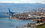
Port of Rijeka, the largest cargo port in Croatia.

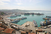
Port of Koper, the largest port in Slovenia
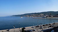
Port of Trieste, the largest cargo port in the Adriatic.

Port of Bar, the largest naval port in Montenegro.
Port of Ancona, a passenger port.


.jpg)

.jpg)

Contenido relacionado
Kingdom of Iberia
Watershed
Maracay
Machu Picchu base
Wadati-Benioff zone