Aburrá Valley
The Valle de Aburrá is a subregion, under the figure of Metropolitan Area located in the center-south of the department of Antioquia, Colombia, in the middle of the Central Cordillera of the Andes.
It is part of the natural basin of the Medellín River. This runs from south to north, receiving a series of tributaries along its route. The Valley has an approximate length of 60 kilometers and a variable width. It is framed by an irregular and sloping topography, with heights ranging between 1,300 and 2,800 m a.s.l. no. m..
The mountain ranges that enclose it give rise to the formation of a very particular urban harmony in terms of the design of the strategies that are required to make effective the constitutional rights of this community to housing, residential public services, creation and defense of public space and protection of the environment.
It is a narrow valley, about 6 km wide on average, although at its widest part it can reach 8 to 10 km. The very direction of the valley is the one observed by Line A of the Medellín Metro, between Bello and La Estrella.
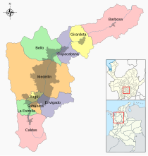
The municipalities inserted in it, considered from north to south, are:
- Northern bore: Barbosa, Girardota, Copacabana, Bello.
- Aburrá Centro: Medellín.
- South bore: Envigado, Itagüí, Sabaneta, La Estrella and Caldas.
Practically the entire flat area of the valley is urbanized, and this has made Medellín and its Metropolitan Area grow more towards the sides and east with urban projects and on the western sides mostly marginal invasions, but on the central eastern area if Several urban interventions have been made.
The Central Cordillera of the Andes bifurcates in two in its very heart, which makes it possible to obtain an unparalleled panoramic view of Medellín and its entire Metropolitan Area in its vicinity.
The Medellín river, which crosses the valley, rises in the municipality of Caldas (south) and converges with the Grande river a few kilometers later to form the Porce, later it pours into the Nechí and in turn the latter flows into the Cauca.
The rapid urban growth of Medellín and the other urban axes within the territorial space of the Valley have created serious environmental problems that, in any case, have gradually generated an awareness of a greener city. There are forests on the outskirts that have received some official protection attention, but the marginal areas of the city have deteriorated the physical space, especially on the slopes.
|


