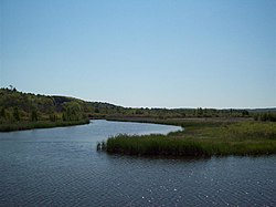
El río Betsie (Betsie) es un río de 86,9 km (54,0 millas) de longitud en el estado estadounidense de Míchigan. Se encuentra en la península inferior noroeste del estado y desemboca en el lago Míchigan en Frankfort. Su curso discurre principalmente dentro del condado de Benzie (cuyo nombre deriva de una variante de la pronunciación del río), aunque nace en el oeste del condado de Grand Traverse y discurre brevemente por el norte del condado de Manistee.El río se ensancha para formar el lago Betsie antes de desembocar en el lago Michigan, entre Frankfort y Elberta. El río Betsie forma parte del Programa de Ríos Naturales de Michigan.Betsie River Wetland Delta cerca de Elberta
Etymology
El nombre deriva del francés la rivière aux Bec-scies, que significa río de patos pico de sierra (bec-scie). Una corrupción de esta pronunciación dio origen al nombre del condado de Benzie. Otros nombres históricos alternativos incluyen los siguientes:
Aug-sig-o-sebe
Aux Buscies River
El río de Betsey
Benzie River
Black Robe River
Gay-she-say-ing
Riviere du Pere Marquette
Sawbill Ducks River
Shelldrake Ducks River
Curso
Si bien la mayoría de las fuentes indican que el río nace como desembocadura del lago Green en el suroeste del condado de Grand Traverse, algunos lo consideran navegable inmediatamente al sur de la US-31, desde el lago Tullers hasta el lago Green. Otro afluente del río fluye directamente desde el norte del lago Duck hacia el norte del lago Green, conectando con la salida del lago Tullers, ya mencionada. Aunque hoy en día no se considera parte del río Betsie, mapas antiguos de la zona sí lo indican. El lago Green se extiende a ambos lados del límite entre los municipios de Grant, al sur, y Green Lake, al norte, entre Karlin e Interlochen. Varios lagos cercanos, incluyendo el lago Duck y sus afluentes, desembocan en el lago Green.El río serpentea hacia el suroeste desde el lago Green hacia el este del condado de Benzie, y luego brevemente hacia el norte del condado de Manistee antes de virar hacia el norte de regreso al condado de Benzie. Una presa en el río forma el estanque Homestead, tras el cual fluye principalmente hacia el oeste y ligeramente hacia el norte hasta el lago Michigan.El río Betsie vaciando en el lago Betsie, Elberta, MI (el puente muestra el M-22 cruzando la salida del río)
Cuenca de drenaje
El río Betsie drena un área de aproximadamente 627,37 km² (155.026 acres) en tres condados. La cuenca de drenaje incluye aproximadamente 150 km (93 millas) de cauce lineal, de los cuales 84 km (52 millas) forman parte del curso principal.
Daños
Homestead Dam 44°35′48′′N 86°04′48′W / 44.59667°N 86.08000°W / 44.59667; -86.08000 fue eliminado en 1974 y actualmente actúa como una barrera de la luminosidad. Implica poco agua y no impide las migraciones salmones. Los restos de la presa ahora se llaman "Homestead Falls". La presa era una instalación generadora de energía antiguamente propiedad de Consumers Energy.
Grass Lake Dam, aproximadamente 4 millas (6 km) aguas abajo desde Green Lake, forma un impoundment de aproximadamente 90 acres (36 ha). La presa fue construida en 1951 para mejorar el hábitat de aves acuáticas y la pesca de pique norte. La presa fue instalada por la División Estatal de Vida Silvestre y creó una inundación de aves acuáticas de 482 acres (195 ha).
Thompsonville Dam era una antigua presa de poder que falló en la primavera de 1989 y fue posteriormente retirada. Antes de su remoción, la presa constituía una barrera para la migración salmón. El salmón y la trucha tienen acceso a toda la corriente del río, incluso por encima de la presa del lago Grass.
Bridges
A continuación se muestra una lista de cruces públicos del río Betsie:
Tonawanda Lake 44°39′03′′N 85°45′07′′W / 44.65083°N 85.75194°W / 44.65083; -85.75194
Ellis Lake 44°39′47′′N 85°44′54′′W / 44.66306°N 85.74833°W / 44.66306; -85.74833
Lago Saunders 44°40′17′′N 85°43′56′W / 44.67139°N 85.73222°W / 44.67139; -85.73222
Notas
^ a b cU.S. Geological Survey Geographic Names Information System: Betsie River
^U.S. Geological Survey. Datos hidrográficos nacionales de alta resolución. El Mapa Nacional Archivado 2012-03-29 en la Máquina Wayback, accedido 21 de noviembre de 2011
^Betsie River, Michigan Departamento de Recursos Naturales
^LLC, Obras de mapa histórico. "Blair - Izquierda, Atlas: Grand Traverse County 1881, Michigan Historical Map". www.historicmapworks.com. Retrieved 2019-08-12.
^ a b c dBetsi River, Mark A. Tonello, "Status of the Fishery Resource Report, Michigan Department of Natural Resources, No. 2004-3, 2004
^ a b c dBetsie River Natural River Plan, Michigan Department of Natural Resources, julio 1973, revisado 12 de marzo de 2002
^U.S. Geological Survey Geographic Names Information System: Homestead Dam
^El río Betsie, los viajes de Canoe de Hanmer
^U.S. Geological Survey Geographic Names Information System: Betsie Lake
^U.S. Geological Survey Geographic Names Information System: Crystal Lake Outlet
^U.S. Geological Survey Geographic Names Information System: Cold Creek
^U.S. Geological Survey Geographic Names Information System: Rice Creek
^U.S. Geological Survey Geographic Names Information System: Dair Creek
^U.S. Geological Survey Geographic Names Information System: Little Betsie River
^U.S. Geological Survey Geographic Names Information System: Pickerel Creek
^U.S. Geological Survey Geographic Names Information System: Twin Lake
^U.S. Geological Survey Geographic Names Information System: Upper Twin Lake
^U.S. Geological Survey Geographic Names Information System: Grass Lake
^U.S. Geological Survey Geographic Names Information System: Mud Lake
^U.S. Geological Survey Geographic Names Information System: Green Lake
^U.S. Geological Survey Geographic Names Information System: Bridge Lake
^U.S. Geological Survey Geographic Names Information System: Tullers Lake
^U.S. Geological Survey Geographic Names Information System: Cedar Hedge Lake
^U.S. Geological Survey Geographic Names Information System: Mud Lake
^U.S. Geological Survey Geographic Names Information System: Duck Lake
^U.S. Geological Survey Geographic Names Information System: Brigham Creek
^U.S. Geological Survey Geographic Names Information System: Mason Creek
^U.S. Geological Survey Geographic Names Information System: Weidenhamer Swamp
^U.S. Geological Survey Geographic Names Information System: Tonawanda Lago
^U.S. Geological Survey Geographic Names Information System: Ellis Lake
^U.S. Geological Survey Geographic Names Information System: Saunders Lake
Enlaces externos
Mapa del río Betsie, Michigan Departamento de Recursos Naturales